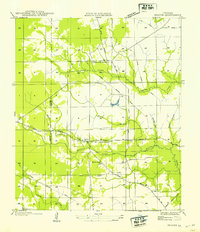
1954 Map of Beaver
USGS Topo · Published 1954About this map
The boundary line between Allen and Evangeline parishes bisects this landscape of timber tracks and riparian lowlands. Grounded by the small community of Beaver and the nearby Cypress Creek Settlement, the area reflects an economy transitioning away from its heavy logging roots. The map is webbed with several Old Logging Railroads and an Old Logging Railroad Grade, indicating where timber was once moved through the dense woods toward regional mills. Central to the local community is the Beaver School, located south of where the State Highway No 482 and State Highway No 25 corridors provide modern access. Water features define the terrain, from the slow-moving Bayou Marsh and Bryans Lake to named drainages like Earnest Gully and Beasty Branch.
Find a feature on this map
20 named features on this map. Tap any name to fly to it.
Don’t see what you’re looking for? This feature index may not catch every label — zoom into the map to look around manually.
Map Details
Editions of this 1954 Beaver Map
This is the sole edition of this map. No revisions or reprints were ever made.
Other maps of this area

1935 · Beaver
USGS Topo · 1:31,680

1935 · Pawnee
USGS Topo · 1:31,680

1935 · Oakdale
USGS Topo · 1:31,680

1935 · Turkey Creek
USGS Topo · 1:62,500

1942 · Oakdale
USGS Topo · 1:62,500

1947 · Foley
USGS Topo · 1:31,680

1947 · Bond
USGS Topo · 1:31,680

1949 · Glenmora
USGS Topo · 1:31,680

1949 · Turkey Creek
USGS Topo · 1:62,500
1950 · Foley
USGS Topo · 1:31,680