1980s Maps of Avoyelles Parish, Louisiana
Explore 14 historic maps of Avoyelles Parish from the 1980s. These maps offer a rare glimpse into what life looked like during the 1980s — showing old roads, neighborhoods, homes, and landmarks that have changed or disappeared over time.
Whether you're researching your family's past, planning a metal detecting trip, or studying how Avoyelles Parish's landscape evolved across the 1980s, these high-resolution maps are a powerful tool for exploring the history of this region.
- Focus on a specific era: All maps on this page are from the 1980s, giving you a focused view of this time period.
- See what’s changed: Compare century-old streets, trails, and buildings to today's modern landscape using overlays and satellite layers.
- Research with precision: Use these maps for genealogy, historical research, land use analysis, or educational projects.
- View, download, or print: Maps are fully viewable online in high resolution, and can be downloaded or printed for your own records.
Start exploring Avoyelles Parish's history through authentic maps from the 1980s. This is your window into the past.
Avoyelles Parish, LA maps
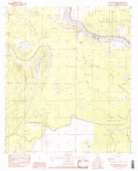
(14)- 1982 Map of Big Bend
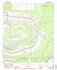 1982 Big Bend1982 Print · USGSAvoyelles Parish near the turn of the 1980s is captured here as a landscape of deep bayous and river floodways. Genealogists can locate family landmarks such as Old Morning Star Ch, Pilgrim Ch, and the winding banks of Bayou des Glaises.
 - 1982 Map of Larto Lake South
 1982 Larto Lake South1982 Print · USGSThe alluvial wetlands of Catahoula Parish appear in the early 1980s as a complex network of bayous, brakes, and managed wildlife areas. Researchers can locate community anchors like Larto Ch and Central Sch or trace the family-named Pease Cem and Nichols Cem near the water.
 - 1982 Map of Marksville South
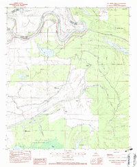
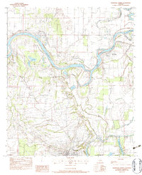
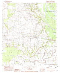 1982 Marksville South1982 Print · USGSCentral Avoyelles Parish in the early eighties shows a landscape deeply tied to its water bodies and rail lines. Trace family roots and local history through St Joseph Cem, the Kansas City Southern railroad, and the wetland reaches of Spring Bayou.2 unique versions available
 - 1982 Map of Acme
 1982 Acme1982 Print · USGSConcordia Parish in the early 1980s reveals a landscape defined by the winding Black River and its dense network of backwater brakes. Genealogists can trace family footprints through the Acme Ch and rural cemeteries like Trisler Cem, or locate long-standing river landings such as Williams Landing Strip.
 - 1982 Map of Ile Natchitoches, 1983 Print
 1982 Ile Natchitoches1983 Print · USGSThe alluvial basin of the Red River is captured here in the early eighties, where water and industry meet in the Louisiana lowlands. Researchers can trace the complex hydrology of Ile Natchitoches and Natchitoches Bayou alongside numerous drill sites and the expanse of Wolf Prairie.
 - 1982 Map of Lac Sainte Agnes, 1983 Print
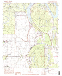
 1982 Lac Sainte Agnes1983 Print · USGSThe alluvial wetlands of Avoyelles Parish are captured in the early 1980s, showcasing a landscape of winding bayous and cypress brakes. Genealogists and researchers can trace local landmarks such as St James Chapel, the settlement of Ophelia, and the family-named Cypriere a Oncle John.
 - 1982 Map of Moreauville, 1983 Print
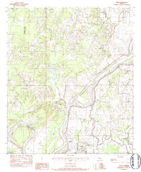
 1982 Moreauville1983 Print · USGSAvoyelles Parish settlements followed the winding curves of the bayous in the early eighties, creating a landscape defined by water and rail. Genealogy researchers can locate family sites near Bordelonville, Sacred Heart Ch, and along the Kansas City Southern line.
 - 1983 Map of New Roads
 1983 New Roads1983 Print · USGSThe river parishes of central Louisiana are documented in the early 1980s, showcasing the winding courses of the Atchafalaya and Mississippi. Genealogists and historians can trace rail-served river towns like Melville and Simmesport, or locate the Port Hudson National Cem and the State Penitentiary.2 unique versions available
 - 1983 Map of Belle D'eau
 1983 Belle D'eau1983 Print · USGSAvoyelles Parish in the early 1980s reveals a landscape of winding bayous and terrace settlements along the Red River valley. Researchers can trace the proximity of family sites to landmarks like St Martin of Tours Ch, Old Island Cem, and the KANSAS CITY SOUTHERN rail line.2 unique versions available
 - 1983 Map of Effie
 1983 Effie1983 Print · USGSAvoyelles and Rapides Parishes are shown in the early 1980s as a patchwork of bayous and small settlements along the Red River. Local historians can trace family roots at Pierce Cem, St Winifred Ch, and the rural center of Effie.
 - 1983 Map of Marksville North
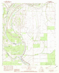
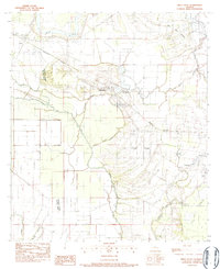
 1983 Marksville North1983 Print · USGSAvoyelles Parish during the early eighties shows a landscape defined by the winding Red River and the sprawling wetlands of the Spring Bayou Wildlife Area. Researchers can trace old family sites at Bordelon Cem or follow the water to Spring Bayou Landing.3 unique versions available
 - 1984 Map of Woodville
 1984 Woodville1984 Print · USGSThe Mississippi-Louisiana borderlands in the mid-eighties show a landscape defined by the shifting MISSISSIPPI RIVER and sprawling timberlands. Researchers can trace the ILLINOIS CENTRAL GULF railroad through Gloster or locate historic river points like Fort Adams and Point Breeze.
 - 1986 Map of Ville Platte
 1986 Ville Platte1986 Print · USGSCentral Louisiana in the 1980s reveals a complex landscape of pine forests and bayou networks spanning seven distinct parishes. Researchers can trace historic rail lines like the Atchison Topeka and Santa Fe RR and locate settlements such as Simmons Settlement, Redland, and Elizabeth.2 unique versions available
 - 1986 Map of Alexandria
 1986 Alexandria1986 Print · USGSCentral Louisiana in the mid-eighties shows a landscape of strategic military installations and deep river-valley agriculture. Researchers can trace the footprints of England Air Force Base, Camp Beauregard, and the extensive Kisatchie National Forest.2 unique versions available
End of results
Showing maps 1-14 of 14
Top cities of Avoyelles Parish
- Marksville historical maps
- Bunkie historical maps
- Cottonport historical maps
- Simmesport historical maps
- Mansura historical maps
- Moreauville historical maps
See more
Frequently asked questions
- What are the different types of historical maps available for Avoyelles Parish?
- What is the oldest map of Avoyelles Parish?
- Where can I purchase historical maps of Avoyelles Parish for my home or office?
- Where can I download high-res historical maps of Avoyelles Parish?
- Are there historical topographic maps available for Avoyelles Parish?
- Is there historical aerial imagery available for Avoyelles Parish?
- Where are historical maps of Avoyelles Parish sourced from?