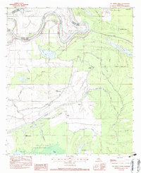
1982 Map of Lac Sainte Agnes
USGS Topo · Published 1983About this map
Red River meanders define the northern boundary of this landscape, where the shifting waters of Old Red River and the Saline Cutoff illustrate the dynamic alluvial history of Avoyelles and Catahoula Parishes. To the south, the terrain transitions into a complex network of wetlands and backwaters, dominated by the Spring Bayou State Wildlife Management Area. Localized settlements like Ophelia and the descriptively named Cypriere a Oncle John sit amidst a labyrinth of bayous and lakes, including Lac Sainte Agnes and Lac Grand Bayou. The presence of St James Chapel and various landing strips like Moonshaven Landing Strip suggests a remote community reliant on both waterborne navigation and small-scale aviation. The intricate drainage patterns of Twisty Bayou and Bayou Cocodrie reflect a landscape shaped by seasonal flooding and the slow movement of water through the Louisiana lowlands.
Find a feature on this map
48 named features on this map. Tap any name to fly to it.
Don’t see what you’re looking for? This feature index may not catch every label — zoom into the map to look around manually.
Map Details
Editions of this 1982 Lac Sainte Agnes Map
This is the sole edition of this map. No revisions or reprints were ever made.
Other maps of this area

1935 · Tooleys
USGS Topo · 1:62,500

1940 · Marksville
USGS Topo · 1:62,500

1941 · Voorhies
USGS Topo · 1:62,500

1941 · Buckeye
USGS Topo · 1:62,500

1941 · Tooleys
USGS Topo · 1:62,500

1953 · Alexandria
USGS Topo · 1:250,000

1953 · Natchez
USGS Topo · 1:250,000

1955 · Alexandria
USGS Topo · 1:250,000

1956 · Natchez
USGS Topo · 1:250,000

1959 · Natchez
USGS Topo · 1:250,000