1930s Maps of Haughton, Louisiana
Explore 2 historic maps of Haughton from the 1930s. These maps offer a rare glimpse into what life looked like during the 1930s — showing old roads, neighborhoods, homes, and landmarks that have changed or disappeared over time.
Whether you're researching your family's past, planning a metal detecting trip, or studying how Haughton's landscape evolved across the 1930s, these high-resolution maps are a powerful tool for exploring the history of this region.
- Focus on a specific era: All maps on this page are from the 1930s, giving you a focused view of this time period.
- See what’s changed: Compare century-old streets, trails, and buildings to today's modern landscape using overlays and satellite layers.
- Research with precision: Use these maps for genealogy, historical research, land use analysis, or educational projects.
- View, download, or print: Maps are fully viewable online in high resolution, and can be downloaded or printed for your own records.
Start exploring Haughton's history through authentic maps from the 1930s. This is your window into the past.
Haughton, LA maps
(2)- 1932 Map of Bossier SE
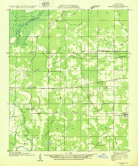 1932 Bossier SE1932 Print · USGSBossier Parish in the early 1930s is a landscape of growing military tracts and rural crossroads settlements. Genealogists can trace family footprints through numerous local landmarks, including Cedar Grove Sch, Rocky Mount Ch, and the Harper cemetery.
 - 1938 Map of Arnsberg
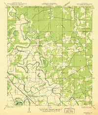 1938 Arnsberg1938 Print · USGSBossier Parish at the end of the 1930s reveals a landscape of dense river meanders and rail-side settlements. Trace family roots and vanished landmarks like Arnsberg, Taylortown, and rural schools such as Marshall Hill Sch or Indian Hill Sch.
End of results
Showing maps 1-2 of 2
Top cities near Haughton
- Shreveport historical maps
- Bossier City historical maps
- Minden historical maps
- Benton historical maps
- Ringgold historical maps
- Sibley historical maps
See more
Frequently asked questions
- What are the different types of historical maps available for Haughton?
- What is the oldest map of Haughton?
- Where can I purchase historical maps of Haughton for my home or office?
- Where can I download high-res historical maps of Haughton?
- Are there historical topographic maps available for Haughton?
- Is there historical aerial imagery available for Haughton?
- Where are historical maps of Haughton sourced from?