1970s Maps of Haughton, Louisiana
Explore 4 historic maps of Haughton from the 1970s. These maps offer a rare glimpse into what life looked like during the 1970s — showing old roads, neighborhoods, homes, and landmarks that have changed or disappeared over time.
Whether you're researching your family's past, planning a metal detecting trip, or studying how Haughton's landscape evolved across the 1970s, these high-resolution maps are a powerful tool for exploring the history of this region.
- Focus on a specific era: All maps on this page are from the 1970s, giving you a focused view of this time period.
- See what’s changed: Compare century-old streets, trails, and buildings to today's modern landscape using overlays and satellite layers.
- Research with precision: Use these maps for genealogy, historical research, land use analysis, or educational projects.
- View, download, or print: Maps are fully viewable online in high resolution, and can be downloaded or printed for your own records.
Start exploring Haughton's history through authentic maps from the 1970s. This is your window into the past.
Haughton, LA maps
(4)- 1972 Map of Koran, 1973 Print
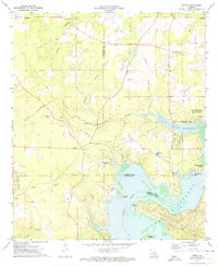 1972 Koran1973 Print · USGSNorthwest Louisiana in the early seventies shows a landscape where parish boundaries meet among the bayous and the expanding Lake Bistineau. Researchers can trace rural lineages through sites like Jerusalem Cem, Suggs Cem, and the community of Koran.2 unique versions available
 - 1972 Map of Ringgold, 1974 Print
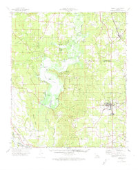 1972 Ringgold1974 Print · USGSThe Louisiana parishes of Bossier, Webster, and Bienville are shown here in the early 1970s as industrial gas fields and lakeside recreation shaped the land. Genealogists can locate several local burial sites including Tooke Cem and Gilmer Cem, or trace the rail lines of the Kansas City Southern.
 - 1975 Map of Eastwood, 1978 Print
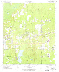 1975 Eastwood1978 Print · USGSBossier Parish in the mid-seventies reveals a landscape transitioning from rural bayous to active military and industrial zones. Researchers can trace the massive Barksdale Air Force Base, old local landmarks like Pease Chapel, and the developing streets of Eastwood.
 - 1978 Map of Bossier City
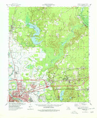 1978 Bossier City1978 Print · USGSBossier City and its surrounding parishes are shown during a period of rapid development and infrastructure growth in the late seventies. Genealogists and local historians can trace family locations near Hillcrest Memorial Park Cem, the historic settlement of Bellevue, or the rural Macedonia Cem.2 unique versions available
End of results
Showing maps 1-4 of 4
Top cities near Haughton
- Shreveport historical maps
- Bossier City historical maps
- Minden historical maps
- Benton historical maps
- Ringgold historical maps
- Sibley historical maps
See more
Frequently asked questions
- What are the different types of historical maps available for Haughton?
- What is the oldest map of Haughton?
- Where can I purchase historical maps of Haughton for my home or office?
- Where can I download high-res historical maps of Haughton?
- Are there historical topographic maps available for Haughton?
- Is there historical aerial imagery available for Haughton?
- Where are historical maps of Haughton sourced from?