Old Maps of Shreveport, Louisiana for Metal Detecting
Plan your next treasure hunt with 77 historic maps of Shreveport. Find old homesites, ghost towns, trails, and gathering spots that may be lost to time — perfect for identifying promising metal detecting locations.
- Locate forgotten sites: Uncover places like long-lost settlements, abandoned rail lines, or gathering spots.
- Plan better hunts: Use map overlays combined with LiDAR or satellite views to narrow in on historically rich areas.
- Made for detectorists: Thousands of hobbyists use these maps to discover relics, coins, and hidden history.
Use these historic maps to boost your research and find new opportunities beneath the surface of Shreveport.
Shreveport, LA maps
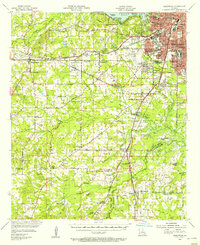
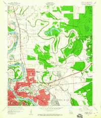
(77)- 1932 Map of Bossier SW
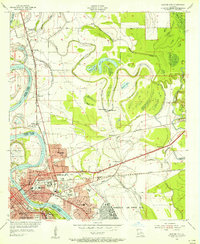
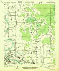 1932 Bossier SW1932 Print · USGSShreveport and Bossier City appear during an era of significant growth, with the newly established Barksdale Field taking shape. Genealogists can trace family footprints at Vanceville, Scottville, and churches like Friendship Ch.
 - 1932 Map of Shreveport SE
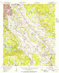
 1932 Shreveport SE1932 Print · USGSNorthwest Louisiana's river country is captured here in the early thirties, showcasing a landscape defined by shifting bayous and new infrastructure. Trace the early growth of Shreveport alongside the Albany Ferry and landmarks like St Matthews Ch and the Rosenwald Sch.
 - 1941 Map of Forbing
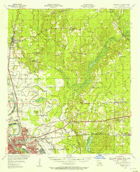
 1941 Forbing1941 Print · USGSThe outskirts of Shreveport and the shifting bends of the Red River come to life just before the mid-century expansion. Genealogists and historians can locate specific rural institutions such as Centenary College, Hood Cem, and the Good Hope Sch among the river's many points and bayous.
 - 1945 Map of Greenwood
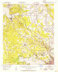
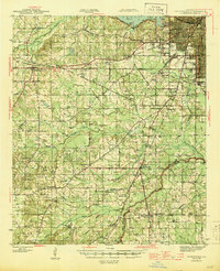 1945 Greenwood1945 Print · USGSShreveport's southwestern outskirts and the rural reaches of Caddo Parish are captured here during the mid-forties. Genealogists can trace family names through numerous landmarks like Marshall Cem, Hall Grove Sch, and the Caddo Parish Penal Farm.
 - 1948 Map of Mooringsport
 1948 Mooringsport1948 Print · USGSNorthwest Louisiana's oil and river country is captured here during the late 1940s, showing the early growth of Mooringsport and Oil City. Researchers can trace rural lineages through numerous local landmarks like the Evening Star Sch and Albany Ferry.
 - 1948 Map of Bossier City
 1948 Bossier City1948 Print · USGSNorthwestern Louisiana during the late 1940s reveals a landscape shaped by the Red River and the expansion of the Bossier City area. Researchers can trace rural family sites near Benton or locate historical landmarks like Barksdale Field and Red River Ch.
 - 1948 Map of Caspiana
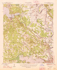
 1948 Caspiana1948 Print · USGSNorthwest Louisiana south of Shreveport is captured here in the late 1940s as the river-and-rail economy shaped the Red River Valley. Genealogists can trace family footprints across dozens of rural landmarks like Blenheim Sch, Robinson Chapel, and Evergreen Cem.
 - 1955 Map of Shreveport
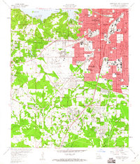
 1955 Shreveport1955 Print · USGSNorthern Louisiana in the mid-fifties is captured here as a landscape of military bases, vast oil fields, and burgeoning college towns. Genealogists and historians can trace the rail-and-river economy through the Monroe Gas Field, Grambling College, and Barksdale Air Force Base.3 unique versions available
 - 1955 Map of Bossier City, 1956 Print
 1955 Bossier City1956 Print · USGSThe Red River valley comes to life in the mid-fifties as the rail-driven economies of Bossier City and Shreveport expand. Genealogists and local historians can trace family roots through neighborhood landmarks like Waller Sch, Greenwood Cemetery, and the historic Mt Zion Ch.
 - 1955 Map of Shreveport East, 1956 Print
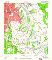
 1955 Shreveport East1956 Print · USGSThe riverfronts of Shreveport and Bossier City are shown in the mid-fifties as urban growth began to fill the bends of the Red River. Researchers can trace the development of Barksdale Air Force Base and locate local landmarks like Byrd High Sch and Red River Cem.
 - 1955 Map of Caspiana, 1956 Print
 1955 Caspiana1956 Print · USGSShreveport and the Red River valley are captured here in the mid-fifties, just as the region's military and agricultural footprint was expanding. Researchers can trace the boundaries of Barksdale Air Force Base or locate rural landmarks like Daisy Grove Sch and Oakland Cem.3 unique versions available
 - 1955 Map of Bossier City, 1956 Print
 1955 Bossier City1956 Print · USGSBossier Parish at the height of the post-war era shows a landscape balancing military aviation and the oil industry with traditional rural settlements. Researchers can trace family roots at Macanesea Cem, locate the Benton Oil and Gas Field, or find the Pleasant Hill Sch (Abandoned).2 unique versions available
 - 1955 Map of North Shreveport, 1956 Print
 1955 North Shreveport1956 Print · USGSShreveport's northern expansion is frozen in time during the mid-fifties as industrial rail lines and oil fields began to press into the Caddo Parish countryside. Genealogists can trace a wealth of community landmarks, from Walker Hill Cemetery to several rural schoolhouses like Center Point School and Round Grove School.
 - 1955 Map of Shreveport West, 1956 Print
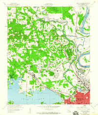
 1955 Shreveport West1956 Print · USGSShreveport's mid-century expansion is captured here as the city grows toward Cross Lake and the western rail corridors. Genealogists and local historians can locate early schools and cemeteries including Coleman College, Hebrew Rest Cem, and the Zion Rest Cem.
 - 1955 Map of Mooringsport, 1956 Print
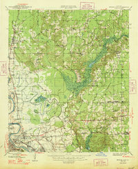
 1955 Mooringsport1956 Print · USGSNorth of Shreveport in the mid-fifties, the landscape was a complex mix of active oil fields, bayou drainage projects, and rural plantations. Researchers can trace family sites at Sentell Plantation, Walker Hill Cem, or the Reed Spring Sch.3 unique versions available
 - 1955 Map of Greenwood, 1956 Print
 1955 Greenwood1956 Print · USGSShreveport and Caddo Parish undergo a mid-century transformation as suburban growth reaches the new airport and the Texas and Pacific rail lines. Genealogists and local historians can trace family-named sites like Pollard Cem, legacy schools like Greenwood Sch, and rural hubs like Keithville.2 unique versions available
 - 1956 Map of Shreveport
 1956 Shreveport1956 Print · USGSNorthern Louisiana during the mid-fifties presents a complex landscape of booming oil fields and strategic military installations. Genealogists and historians can trace the infrastructure of the Monroe Gas Field and family-named locales from Cotton Valley to Jonesboro.
 - 1959 Map of Shreveport West, 1960 Print
 1959 Shreveport West1960 Print · USGSShreveport and its western outskirts appear in the late fifties as suburban expansion reaches toward the pine forests. Genealogists and researchers can trace family landmarks like St Vincent Academy, Jewella, and the Centuries Memorial Cem during a period of significant local growth.2 unique versions available
 - 1959 Map of Shreveport East, 1960 Print
 1959 Shreveport East1960 Print · USGSShreveport and Bossier City are seen at a mid-century peak of expansion along the oxbows of the Red River. Researchers can trace neighborhood growth near Centenary College or locate rural landmarks like Red River Cem and the Mary Goula Ch.2 unique versions available
 - 1960 Map of North Highlands
 1960 North Highlands1960 Print · USGSShreveport and its northern suburbs reached toward the Red River in the early sixties as new infrastructure transformed the Caddo Parish landscape. Genealogists and local historians can trace the foundations of neighborhoods near Northside Sch, locate family plots at Walker Hill Cem, and follow the old rail lines of the Texas and Pacific.2 unique versions available
 - 1960 Map of Bossier City
 1960 Bossier City1960 Print · USGSBossier City and Shreveport are shown at a peak of post-war growth as the urban center expands toward the Red River. Researchers can trace mid-century neighborhoods near Plantation Park Sch or locate rural landmarks like Mt Zion Ch and Vanceville.2 unique versions available
 - 1975 Map of Bossier City, 1976 Print
 1975 Bossier City1976 Print · USGSBossier Parish and the Red River banks are captured in high-detail aerial photography during the mid-seventies growth of the Shreveport area. Researchers can trace the development of Bossier City, the sprawling footprint of Barksdale Air Force Base, and the rural character of Brownlee.3 unique versions available
 - 1975 Map of North Highlands, 1976 Print
 1975 North Highlands1976 Print · USGSNorthwestern Louisiana comes into focus in the mid-seventies as the urban landscape expands along the Red River corridor. Trace the shoreline of Cross Lake and the development of North Highlands in this detailed aerial perspective.
 - 1975 Map of Shreveport East, 1976 Print
 1975 Shreveport East1976 Print · USGSShreveport and Bossier City appear during the mid-seventies, split by the winding course of the Red River. Researchers can trace the layout of Barksdale Air Force Base and the dense urban development within Shreveport.
 - 1975 Map of Shreveport West, 1976 Print
 1975 Shreveport West1976 Print · USGSShreveport's western suburbs and industrial corridors are captured in high detail during the mid-seventies in this aerial orthophotomap. Genealogists and local historians can trace residential growth near Cross Lake or examine the 1975 layout of Summer Grove and Shreveport.
Showing maps 1-25 of 77
Top cities near Shreveport
- Bossier City historical maps
- Blanchard historical maps
- Greenwood historical maps
- Benton historical maps
- Stonewall historical maps
- Mooringsport historical maps
Top neighborhoods of Shreveport
- Pine Hill Estates historical maps
- Dorian Terrace historical maps
- Highland Square historical maps
- Gas Center historical maps
- Good Roads historical maps
- North Highlands historical maps
See more
Frequently asked questions
- What are the different types of historical maps available for Shreveport?
- What is the oldest map of Shreveport?
- Where can I purchase historical maps of Shreveport for my home or office?
- Where can I download high-res historical maps of Shreveport?
- Are there historical topographic maps available for Shreveport?
- Is there historical aerial imagery available for Shreveport?
- Where are historical maps of Shreveport sourced from?