1980s Maps of Delcambre, Louisiana
Explore 2 historic maps of Delcambre from the 1980s. These maps offer a rare glimpse into what life looked like during the 1980s — showing old roads, neighborhoods, homes, and landmarks that have changed or disappeared over time.
Whether you're researching your family's past, planning a metal detecting trip, or studying how Delcambre's landscape evolved across the 1980s, these high-resolution maps are a powerful tool for exploring the history of this region.
- Focus on a specific era: All maps on this page are from the 1980s, giving you a focused view of this time period.
- See what’s changed: Compare century-old streets, trails, and buildings to today's modern landscape using overlays and satellite layers.
- Research with precision: Use these maps for genealogy, historical research, land use analysis, or educational projects.
- View, download, or print: Maps are fully viewable online in high resolution, and can be downloaded or printed for your own records.
Start exploring Delcambre's history through authentic maps from the 1980s. This is your window into the past.
Delcambre, LA maps
(2)- 1983 Map of White Lake
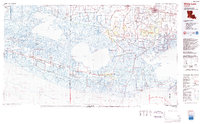 1983 White Lake1983 Print · USGSCoastal Louisiana at the start of the 1980s reveals a world of remote chenier settlements and vast marshlands. Genealogists and historians can trace family locations along Grand Chenier Ridge or explore the hubs of Abbeville and Intracoastal City.2 unique versions available
 - 1983 Map of Morgan City
 1983 Morgan City1983 Print · USGSThe Louisiana coast in the early eighties reveals a landscape shaped by water and industry, from the salt domes to the sugar parishes. Trace the historic corridor of the Bayou Teche, the rail lines through Morgan City, and the wetlands of Weeks Island.2 unique versions available
End of results
Showing maps 1-2 of 2
Top cities near Delcambre
- Lafayette historical maps
- New Iberia historical maps
- Abbeville historical maps
- Youngsville historical maps
- Erath historical maps
- Maurice historical maps
Top neighborhoods of Delcambre
Frequently asked questions
- What are the different types of historical maps available for Delcambre?
- What is the oldest map of Delcambre?
- Where can I purchase historical maps of Delcambre for my home or office?
- Where can I download high-res historical maps of Delcambre?
- Are there historical topographic maps available for Delcambre?
- Is there historical aerial imagery available for Delcambre?
- Where are historical maps of Delcambre sourced from?