1990s Maps of Delcambre, Louisiana
Explore 2 historic maps of Delcambre from the 1990s. These maps offer a rare glimpse into what life looked like during the 1990s — showing old roads, neighborhoods, homes, and landmarks that have changed or disappeared over time.
Whether you're researching your family's past, planning a metal detecting trip, or studying how Delcambre's landscape evolved across the 1990s, these high-resolution maps are a powerful tool for exploring the history of this region.
- Focus on a specific era: All maps on this page are from the 1990s, giving you a focused view of this time period.
- See what’s changed: Compare century-old streets, trails, and buildings to today's modern landscape using overlays and satellite layers.
- Research with precision: Use these maps for genealogy, historical research, land use analysis, or educational projects.
- View, download, or print: Maps are fully viewable online in high resolution, and can be downloaded or printed for your own records.
Start exploring Delcambre's history through authentic maps from the 1990s. This is your window into the past.
Delcambre, LA maps
(2)- 1994 Map of Abbeville East, 1998 Print
 1994 Abbeville East1998 Print · USGSVermilion Parish in the mid-1990s shows a landscape defined by the sugar and energy industries. Researchers can trace family history through sites like Trahan Cem or explore the infrastructure of the Erath Oil and Gas Field and Henry.
 - 1994 Map of Delcambre, 1998 Print
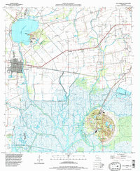 1994 Delcambre1998 Print · USGSThe salt domes and marshes of Iberia and Vermilion parishes are captured here in the mid-nineties, showing a landscape defined by industrial canals and coastal wetlands. Researchers can locate family landmarks like Miguel Cem, the heights of Avery Island, and settlements such as Bob Acres and Broussville.
End of results
Showing maps 1-2 of 2
Top cities near Delcambre
- Lafayette historical maps
- New Iberia historical maps
- Abbeville historical maps
- Youngsville historical maps
- Erath historical maps
- Maurice historical maps
Top neighborhoods of Delcambre
Frequently asked questions
- What are the different types of historical maps available for Delcambre?
- What is the oldest map of Delcambre?
- Where can I purchase historical maps of Delcambre for my home or office?
- Where can I download high-res historical maps of Delcambre?
- Are there historical topographic maps available for Delcambre?
- Is there historical aerial imagery available for Delcambre?
- Where are historical maps of Delcambre sourced from?