Old Maps of Delcambre, Louisiana
Explore 30 old maps of Delcambre, spanning from 1932 to today. These high-resolution historic maps reveal how streets, neighborhoods, landmarks, and natural features evolved over time — perfect for genealogy, metal detecting, research, and local history exploration.
What you can do with these maps:
- See how Delcambre changed over time: Compare historical maps to modern-day views to trace roads, homesites, rail lines & more.
- View detailed metadata: Each map includes creators, publishers, year, scale, and archive source.
- Overlay maps with satellite & LiDAR: Visualize the past alongside modern tools to explore terrain & human change.
- Trusted historical sources: Maps sourced from the USGS, Library of Congress, and other archives.
- Access maps your way: View online, download high-res files, or order prints for personal or research use.
Start exploring old maps of Delcambre to uncover forgotten places, hidden landmarks, and the deep history beneath your feet.
Delcambre, LA maps
(30)- 1932 Map of Abbeville NE
 1932 Abbeville NE1932 Print · USGSVermilion Parish comes into focus during the early 1930s, showing a landscape defined by the Southern Pacific rail line and the winding Vermilion Bayou. Genealogists and historians can trace family roots through markers like Landry Cem, Rose Hill Ch, and the rural community of Erath.
 - 1937 Map of Derouen, 1963 Print
 1937 Derouen1963 Print · USGSCoastal Louisiana in the late 1930s is revealed here as a landscape of salt domes and sugarcane plantations linked by rail and marsh. Genealogists and historians can trace family locations through Duboin Plantation, St Helens Church, and the settlement of Delcambre.
 - 1945 Map of New Orleans
 1945 New Orleans1945 Print · USGSCoastal Louisiana and the Mississippi delta are captured here just after the war, showing the region's transition into a modern industrial and transit hub. Genealogists can trace family settlements along Bayou Teche or identify rail stops for the Illinois Central and Texas & Pacific lines.
 - 1954 Map of Port Arthur
 1954 Port Arthur1954 Print · USGSThe Texas and Louisiana coastlines meet here in the mid-fifties, showing the industrial rise of Port Arthur alongside vast wildlife preserves. Researchers can trace remote coastal settlements and infrastructure like Pecan Island, the Sabine Pass Lighthouse, and the North Island School.
 - 1954 Map of Abbeville, 1956 Print
 1954 Abbeville1956 Print · USGSVermilion Parish in the mid-fifties is captured here as a landscape of river-fed commerce and coastal marsh. Genealogists can trace family heritage through sites like Live Oak Plantation, Briggs Chapel, and the Mouton Cove Sch.3 unique versions available
 - 1956 Map of Port Arthur, 1965 Print
 1956 Port Arthur1965 Print · USGSThe Texas and Louisiana coastlines meet here in the mid-fifties, showing a landscape of sprawling marshes and growing refinery towns. Genealogists and historians can trace ridge settlements like Grand Cheniere or find the Sabine Pass Lighthouse and Pecan Island.3 unique versions available
 - 1958 Map of Port Arthur
 1958 Port Arthur1958 Print · USGSThe Texas and Louisiana coastlines meet in the late fifties at the busy industrial port of Port Arthur. Historians and genealogists can trace the early rail networks of the Southern Pacific and locate coastal settlements like Cameron, Pecan Island, and Abbeville.
 - 1959 Map of Port Arthur
 1959 Port Arthur1959 Print · USGSThe Texas and Louisiana coastlines meet in this late-fifties study of a landscape defined by industry and wildlife preserves. Trace the Intracoastal Waterway past Pecan Island and Abbeville, or locate the shipping channels at Sabine Pass.
 - 1963 Map of New Orleans
 1963 New Orleans1963 Print · USGSCoastal Louisiana in the mid-twentieth century reveals a complex world of bayou settlements, expanding oil fields, and vital rail networks. Genealogists and historians can trace family roots through river towns like Thibodaux or follow the Southern Pacific line through Franklin and Patterson.4 unique versions available
 - 1963 Map of Delcambre, 1964 Print
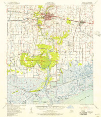
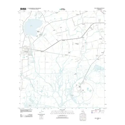
 1963 Delcambre1964 Print · USGSCoastal Louisiana marshes and unique salt dome topography are showcased here during the mid-century. Genealogists and historians can trace rail-side settlements like Broussville and explore the detailed grounds of Avery Island and Jungle Gardens.2 unique versions available
 - 1963 Map of Derouen, 1968 Print
 1963 Derouen1968 Print · USGSCoastal Iberia Parish comes into focus during the early 1960s, showing the intersection of salt dome industry and traditional bayou life. Genealogists and researchers can trace family lands near Duboin Plantation, New Iberia, and the historic St Joseph Cem.
 - 1966 Map of Derouen
 1966 Derouen1966 Print · USGSThe coastal marshlands and industrial salt domes of South Louisiana are captured here in the mid-1960s. Genealogists and local historians can trace family-named sites like Broussville and Migues, or explore industrial landmarks at Avery Island and the Port of New Iberia.
 - 1966 Map of New Orleans
 1966 New Orleans1966 Print · USGSCoastal Louisiana in the mid-1960s reveals a transition from traditional bayou life to an intensive offshore oil and gas economy. Researchers can trace the rail lines of the Southern Pacific RR through Morgan City or locate the Eugene Island Lighthouse among the delta's shifting marshes.
 - 1973 Map of Port Arthur, 1974 Print
 1973 Port Arthur1974 Print · USGSThe Texas-Louisiana borderlands in the early seventies reveal an intricate landscape of coastal marshes and heavy industry. Trace the growth of Port Arthur, the extent of the oil and gas fields, and old ridge settlements like Pecan Island.
 - 1975 Map of Abbeville East, 1978 Print
 1975 Abbeville East1978 Print · USGSVermilion Parish in the mid-seventies reveals a unique intersection of Cajun agricultural life and the booming energy industry. Researchers can trace the development of Erath and Abbeville while identifying local landmarks like Rose Hill Ch, Crawfish Farms, and numerous family cemeteries.
 - 1975 Map of Abbeville, 1978 Print
 1975 Abbeville1978 Print · USGSThe Vermilion Parish coast in the mid-seventies shows a landscape defined by the Vermilion River and the industrial activity of the Intracoastal Waterway. Researchers can locate historic local landmarks including Live Oak Plantation, St Paul Cem, and the settlement at Intracoastal City.
 - 1983 Map of White Lake
 1983 White Lake1983 Print · USGSCoastal Louisiana at the start of the 1980s reveals a world of remote chenier settlements and vast marshlands. Genealogists and historians can trace family locations along Grand Chenier Ridge or explore the hubs of Abbeville and Intracoastal City.2 unique versions available
 - 1983 Map of Morgan City
 1983 Morgan City1983 Print · USGSThe Louisiana coast in the early eighties reveals a landscape shaped by water and industry, from the salt domes to the sugar parishes. Trace the historic corridor of the Bayou Teche, the rail lines through Morgan City, and the wetlands of Weeks Island.2 unique versions available
 - 1994 Map of Abbeville East, 1998 Print
 1994 Abbeville East1998 Print · USGSVermilion Parish in the mid-1990s shows a landscape defined by the sugar and energy industries. Researchers can trace family history through sites like Trahan Cem or explore the infrastructure of the Erath Oil and Gas Field and Henry.
 - 1994 Map of Delcambre, 1998 Print
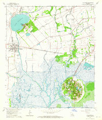
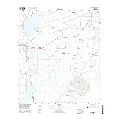
 1994 Delcambre1998 Print · USGSThe salt domes and marshes of Iberia and Vermilion parishes are captured here in the mid-nineties, showing a landscape defined by industrial canals and coastal wetlands. Researchers can locate family landmarks like Miguel Cem, the heights of Avery Island, and settlements such as Bob Acres and Broussville.
 - 2012 Map of Abbeville East, 2012 Print
 2012 Abbeville East2012 Print · USGSCovers Delcambre, including Abbeville, Erath, and other nearby areas
 - 2012 Map of Delcambre, 2012 Print
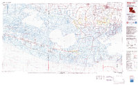
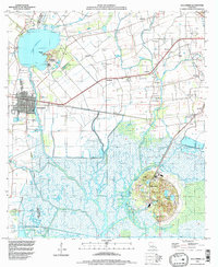
 2012 Delcambre2012 Print · USGSCovers Delcambre, including Derouen, Emma, and other nearby areas
 - 2015 Map of Abbeville East, 2015 Print
 2015 Abbeville East2015 Print · USGSCovers Delcambre, including Abbeville, Erath, and other nearby areas
 - 2015 Map of Delcambre, 2015 Print
 2015 Delcambre2015 Print · USGSCovers Delcambre, including Derouen, Emma, and other nearby areas
 - 2018 Map of Abbeville East, 2018 Print
 2018 Abbeville East2018 Print · USGSCovers Delcambre, including Abbeville, Erath, and other nearby areas
Showing maps 1-25 of 30
Top cities near Delcambre
- Lafayette historical maps
- New Iberia historical maps
- Abbeville historical maps
- Youngsville historical maps
- Erath historical maps
- Maurice historical maps
Top neighborhoods of Delcambre
Frequently asked questions
- What are the different types of historical maps available for Delcambre?
- What is the oldest map of Delcambre?
- Where can I purchase historical maps of Delcambre for my home or office?
- Where can I download high-res historical maps of Delcambre?
- Are there historical topographic maps available for Delcambre?
- Is there historical aerial imagery available for Delcambre?
- Where are historical maps of Delcambre sourced from?