1980s Maps of Old Pleasant Hill, Louisiana
Explore 2 historic maps of Old Pleasant Hill from the 1980s. These maps offer a rare glimpse into what life looked like during the 1980s — showing old roads, neighborhoods, homes, and landmarks that have changed or disappeared over time.
Whether you're researching your family's past, planning a metal detecting trip, or studying how Old Pleasant Hill's landscape evolved across the 1980s, these high-resolution maps are a powerful tool for exploring the history of this region.
- Focus on a specific era: All maps on this page are from the 1980s, giving you a focused view of this time period.
- See what’s changed: Compare century-old streets, trails, and buildings to today's modern landscape using overlays and satellite layers.
- Research with precision: Use these maps for genealogy, historical research, land use analysis, or educational projects.
- View, download, or print: Maps are fully viewable online in high resolution, and can be downloaded or printed for your own records.
Start exploring Old Pleasant Hill's history through authentic maps from the 1980s. This is your window into the past.
Old Pleasant Hill, LA maps
(2)- 1986 Map of Natchitoches
 1986 Natchitoches1986 Print · USGSNorthwestern Louisiana during the mid-eighties shows a landscape shaped by major water projects and timberlands. Researchers can trace historic routes like the Old Spanish Trail or locate rural communities such as Fort Jesup, Fairview Alpha, and Grappes Bluff.2 unique versions available
 - 1989 Map of Pleasant Hill
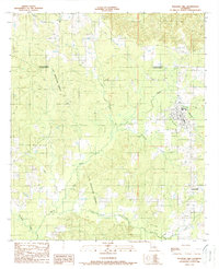 1989 Pleasant Hill1989 Print · USGSPleasant Hill and the surrounding piney woods of Sabine Parish are captured here in the late eighties as the local energy industry expanded. Genealogists and historians can trace the bounds of the Las Ormigas Grant or locate residents near Spring Ridge and Pleasant Hill.
End of results
Showing maps 1-2 of 2
Top cities near Old Pleasant Hill
- Mansfield historical maps
- Coushatta historical maps
- Zwolle historical maps
- Pleasant Hill historical maps
- Converse historical maps
- South Mansfield historical maps
See more
Frequently asked questions
- What are the different types of historical maps available for Old Pleasant Hill?
- What is the oldest map of Old Pleasant Hill?
- Where can I purchase historical maps of Old Pleasant Hill for my home or office?
- Where can I download high-res historical maps of Old Pleasant Hill?
- Are there historical topographic maps available for Old Pleasant Hill?
- Is there historical aerial imagery available for Old Pleasant Hill?
- Where are historical maps of Old Pleasant Hill sourced from?