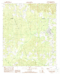
1989 Map of Pleasant Hill
USGS Topo · Published 1989About this map
The Las Ormigas Grant occupies a significant portion of the landscape along the border of De Soto and Sabine Parishes, reflecting the complex land ownership patterns rooted in Spanish colonial history. This 1980s landscape is defined by the extensive Oil and Gas Field operations that dot the area west of Pleasant Hill, where the street grid of the town meets the winding drainage of Hampton Branch. The topography is dominated by a dense network of watercourses, including the meandering Bayou San Miguel and the aptly named Lost Bayou. Smaller settlements like Spring Ridge appear in the southeast, situated near the headwaters of local creeks. The map provides a clear look at the intersection of rural industry and historical land grants just before the close of the twentieth century.
Find a feature on this map
12 named features on this map. Tap any name to fly to it.
Don’t see what you’re looking for? This feature index may not catch every label — zoom into the map to look around manually.
Map Details
Editions of this 1989 Pleasant Hill Map
This is the sole edition of this map. No revisions or reprints were ever made.
Other maps of this area

1938 · Chemard Lake
USGS Topo · 1:31,680

1938 · Hollis Creek
USGS Topo · 1:31,680

1941 · Zwolle
USGS Topo · 1:62,500

1941 · Pelican
USGS Topo · 1:62,500

1942 · Many
USGS Topo · 1:62,500

1943 · Many
USGS Topo · 1:62,500

1943 · Pleasant Hill
USGS Topo · 1:62,500

1944 · Zwolle
USGS Topo · 1:62,500

1944 · Pleasant Hill
USGS Topo · 1:62,500

1947 · Hanna
USGS Topo · 1:62,500