1940s Maps of East Baton Rouge Parish, Louisiana
Explore 3 historic maps of East Baton Rouge Parish from the 1940s. These maps offer a rare glimpse into what life looked like during the 1940s — showing old roads, neighborhoods, homes, and landmarks that have changed or disappeared over time.
Whether you're researching your family's past, planning a metal detecting trip, or studying how East Baton Rouge Parish's landscape evolved across the 1940s, these high-resolution maps are a powerful tool for exploring the history of this region.
- Focus on a specific era: All maps on this page are from the 1940s, giving you a focused view of this time period.
- See what’s changed: Compare century-old streets, trails, and buildings to today's modern landscape using overlays and satellite layers.
- Research with precision: Use these maps for genealogy, historical research, land use analysis, or educational projects.
- View, download, or print: Maps are fully viewable online in high resolution, and can be downloaded or printed for your own records.
Start exploring East Baton Rouge Parish's history through authentic maps from the 1940s. This is your window into the past.
East Baton Rouge Parish, LA maps
(3)- 1942 Map of Pine Grove
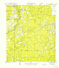 1942 Pine Grove1942 Print · USGSSt. Helena Parish and the surrounding borderlands are captured here in the early 1940s as the regional logging rail era gives way to a modern highway network. Researchers can trace family sites at Sand Hill Cem and Salem Ch, or locate vanished local landmarks like Story Sch and the Old Grade.
 - 1942 Map of Pride
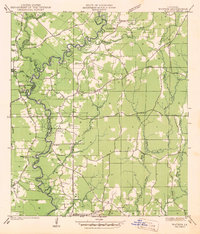
 1942 Pride1942 Print · USGSEast Baton Rouge and surrounding parishes are shown here in the early 1940s, a landscape defined by the Amite River and rural crossroads. You can trace community roots through many local landmarks, including Dennis Mills, Harrell Sch, and Stony Point Cem.
 - 1942 Map of Watson
 1942 Watson1942 Print · USGSLivingston and East Baton Rouge parishes are documented here during the early war years, centered on the community of Watson. Genealogists can locate family landmarks like Womack Cem and Odom Cem, or trace the grounds of the Greenwell Springs Sanatorium.
End of results
Showing maps 1-3 of 3
Top cities of East Baton Rouge Parish
- Baton Rouge historical maps
- St. George historical maps
- Central historical maps
- Baker historical maps
- Zachary historical maps
Frequently asked questions
- What are the different types of historical maps available for East Baton Rouge Parish?
- What is the oldest map of East Baton Rouge Parish?
- Where can I purchase historical maps of East Baton Rouge Parish for my home or office?
- Where can I download high-res historical maps of East Baton Rouge Parish?
- Are there historical topographic maps available for East Baton Rouge Parish?
- Is there historical aerial imagery available for East Baton Rouge Parish?
- Where are historical maps of East Baton Rouge Parish sourced from?