1980s Maps of East Baton Rouge Parish, Louisiana
Explore 7 historic maps of East Baton Rouge Parish from the 1980s. These maps offer a rare glimpse into what life looked like during the 1980s — showing old roads, neighborhoods, homes, and landmarks that have changed or disappeared over time.
Whether you're researching your family's past, planning a metal detecting trip, or studying how East Baton Rouge Parish's landscape evolved across the 1980s, these high-resolution maps are a powerful tool for exploring the history of this region.
- Focus on a specific era: All maps on this page are from the 1980s, giving you a focused view of this time period.
- See what’s changed: Compare century-old streets, trails, and buildings to today's modern landscape using overlays and satellite layers.
- Research with precision: Use these maps for genealogy, historical research, land use analysis, or educational projects.
- View, download, or print: Maps are fully viewable online in high resolution, and can be downloaded or printed for your own records.
Start exploring East Baton Rouge Parish's history through authentic maps from the 1980s. This is your window into the past.
East Baton Rouge Parish, LA maps
(7)- 1980 Map of Pride, 1981 Print
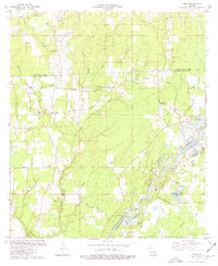 1980 Pride1981 Print · USGSThe rural parishes north of Baton Rouge are documented here in the early eighties as the gravel industry expanded along the Amite River. Genealogists can trace family roots through numerous sites like Mahoney Cem, South Union Cem, and the Pride Lookout Tower.
 - 1980 Map of Pine Grove, 1981 Print
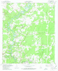
 1980 Pine Grove1981 Print · USGSParish life in the early eighties centers on the riverbanks and timberlands near Pine Grove. Genealogists and researchers can trace family landmarks like Mt Pleasant Ch Cem and Grangeville or follow the path of the Old Railroad Grade.
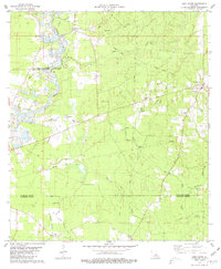
 - 1980 Map of Watson, 1981 Print
 1980 Watson1981 Print · USGSSettlements along the Amite River corridor thrived in the late seventies as rural communities like Watson and Greenwell Springs expanded. Researchers can find old family cemeteries like Newsom Cem and significant local landmarks like the Indian Mound.
 - 1983 Map of New Roads
 1983 New Roads1983 Print · USGSThe river parishes of central Louisiana are documented in the early 1980s, showcasing the winding courses of the Atchafalaya and Mississippi. Genealogists and historians can trace rail-served river towns like Melville and Simmesport, or locate the Port Hudson National Cem and the State Penitentiary.2 unique versions available
 - 1983 Map of Amite
 1983 Amite1983 Print · USGSThe Florida Parishes and southern Mississippi are captured here in the early 1980s, centered on the Illinois Central Gulf rail corridor. Genealogists and historians can trace family-named sites like the Camp Moore Confederate Cem, Magnolia Ch, and the Idlewild Plantation (State University).
 - 1983 Map of Ponchatoula, 1984 Print
 1983 Ponchatoula1984 Print · USGSThe Lake Pontchartrain Basin and the River Parishes come into focus during the early 1980s, showcasing the region's complex water-dependent geography. Researchers can trace the rail routes of the Illinois Central Gulf Railroad and explore landmarks from Pass Manchac to Donaldsonville.2 unique versions available
 - 1984 Map of Baton Rouge
 1984 Baton Rouge1984 Print · USGSBaton Rouge and the surrounding river country are captured in the mid-eighties as the industrial corridor met the deep wetlands of the basin. Researchers can trace the winding Bayou Teche, locate family roots in St Martinville, or study the massive Atchafalaya Basin Floodway.2 unique versions available
End of results
Showing maps 1-7 of 7
Top cities of East Baton Rouge Parish
- Baton Rouge historical maps
- St. George historical maps
- Central historical maps
- Baker historical maps
- Zachary historical maps
Frequently asked questions
- What are the different types of historical maps available for East Baton Rouge Parish?
- What is the oldest map of East Baton Rouge Parish?
- Where can I purchase historical maps of East Baton Rouge Parish for my home or office?
- Where can I download high-res historical maps of East Baton Rouge Parish?
- Are there historical topographic maps available for East Baton Rouge Parish?
- Is there historical aerial imagery available for East Baton Rouge Parish?
- Where are historical maps of East Baton Rouge Parish sourced from?