1950s Maps of Franklin Parish, Louisiana
Explore 11 historic maps of Franklin Parish from the 1950s. These maps offer a rare glimpse into what life looked like during the 1950s — showing old roads, neighborhoods, homes, and landmarks that have changed or disappeared over time.
Whether you're researching your family's past, planning a metal detecting trip, or studying how Franklin Parish's landscape evolved across the 1950s, these high-resolution maps are a powerful tool for exploring the history of this region.
- Focus on a specific era: All maps on this page are from the 1950s, giving you a focused view of this time period.
- See what’s changed: Compare century-old streets, trails, and buildings to today's modern landscape using overlays and satellite layers.
- Research with precision: Use these maps for genealogy, historical research, land use analysis, or educational projects.
- View, download, or print: Maps are fully viewable online in high resolution, and can be downloaded or printed for your own records.
Start exploring Franklin Parish's history through authentic maps from the 1950s. This is your window into the past.
Franklin Parish, LA maps
(11)- 1953 Map of Natchez, 1966 Print
 1953 Natchez1966 Print · USGSSouthwest Mississippi and the Louisiana border country come alive in this mid-century survey of the river valley and forest lands. Researchers can trace the rail lines of the Illinois Central RR and locate rural hubs like Gloster and Ferriday.3 unique versions available
 - 1955 Map of Jackson
 1955 Jackson1955 Print · USGSThe Lower Mississippi Valley at the middle of the century reveals a landscape of deep river meanders and growing rail hubs. Genealogists and historians can trace the mid-century footprints of Vicksburg National Military Park, old river landings at Port Gibson, and the rail corridors of the Illinois Central Railroad.3 unique versions available
 - 1956 Map of Natchez
 1956 Natchez1956 Print · USGSThe Mississippi River borderlands and the Pine Hills come alive in this mid-fifties study of the Natchez region. Genealogists and historians can trace rail-era towns along the Illinois Central RR and explore the oxbows of Lake Bruin and Lake Concordia.
 - 1957 Map of Sicily Island
 1957 Sicily Island1957 Print · USGSCatahoula Parish and the surrounding lowlands are captured in the late 1950s, showing a landscape shaped by the Tensas River and its many bayous. Genealogists can trace family roots at New Zion Ch & Cem 37, Loam Land Sch & Cem, or the old Lee Bayou School House.2 unique versions available
 - 1957 Map of Mangham, 1958 Print
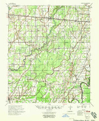
 1957 Mangham1958 Print · USGSRichland and Franklin Parishes in the late fifties reveal a landscape of river-bottom agriculture and small rail towns. Genealogists can trace family roots through numerous local landmarks like Rhymes High Sch, St Luke Cem, and Mt Zion Ch.3 unique versions available
 - 1958 Map of Baskinton
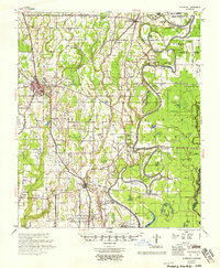
 1958 Baskinton1958 Print · USGSRichland and Franklin Parishes in the late fifties show a landscape transitioning between traditional bayou life and the post-war energy boom. Researchers can locate vanished rural landmarks like Hunters Chapel, the Delhi Refining Co, and old river stops like Indian Ldg.2 unique versions available
 - 1958 Map of Shackleford Lake
 1958 Shackleford Lake1958 Print · USGSTensas Parish was a landscape of timber and river landings in the mid-1950s, where the logging industry and the river's flow dictated local life. Genealogists and historians can trace the foundations of communities at Marydale Plantation, Magnolia Sch & Ch, and ancient sites like the Indian Mounds.
 - 1958 Map of Winnsboro
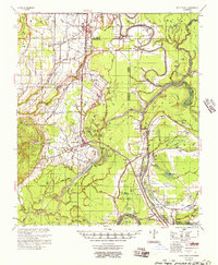
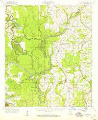
 1958 Winnsboro1958 Print · USGSThe fertile landscape of Franklin Parish comes to life in the late 1950s, showing a region defined by the Missouri Pacific Railroad and the winding Macon Bayou. Genealogists and local historians can trace family locations near landmarks like True Light Cem & Ch, the Franklin Parish Training Sch, and Lorelein.
 - 1958 Map of Fort Necessity, 1959 Print
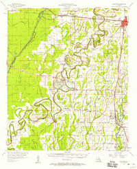
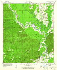
 1958 Fort Necessity1959 Print · USGSThe Louisiana bottomlands of Franklin Parish are captured here in the late fifties, defined by the winding Boeuf River and dense bayou networks. Researchers can locate vanished landmarks and family cemeteries like Long Lake Cem, the Ft Necessity Sch, and Liddieville.3 unique versions available
 - 1959 Map of Natchez
 1959 Natchez1959 Print · USGSSouthwestern Mississippi and eastern Louisiana are captured in the late fifties, showing a landscape defined by the winding Mississippi River and the timbered Homochitto National Forest. Researchers can trace the sprawling Illinois Central RR and find rural landmarks like Union Church and Camp Van Dorn (Abandoned).
 - 1959 Map of Harrisonburg, 1960 Print
 1959 Harrisonburg1960 Print · USGSThe Ouachita River valley comes to life in this late 1950s portrait of Catahoula Parish, showing a landscape of deep bayous and steep hills. Researchers can locate ancestral sites like Old Spring Ridge Cem, the community of Enterprise, and ancient Indian Mounds along the river bluffs.3 unique versions available
End of results
Showing maps 1-11 of 11
Top cities of Franklin Parish
Frequently asked questions
- What are the different types of historical maps available for Franklin Parish?
- What is the oldest map of Franklin Parish?
- Where can I purchase historical maps of Franklin Parish for my home or office?
- Where can I download high-res historical maps of Franklin Parish?
- Are there historical topographic maps available for Franklin Parish?
- Is there historical aerial imagery available for Franklin Parish?
- Where are historical maps of Franklin Parish sourced from?