1960s Maps of Franklin Parish, Louisiana
Explore 5 historic maps of Franklin Parish from the 1960s. These maps offer a rare glimpse into what life looked like during the 1960s — showing old roads, neighborhoods, homes, and landmarks that have changed or disappeared over time.
Whether you're researching your family's past, planning a metal detecting trip, or studying how Franklin Parish's landscape evolved across the 1960s, these high-resolution maps are a powerful tool for exploring the history of this region.
- Focus on a specific era: All maps on this page are from the 1960s, giving you a focused view of this time period.
- See what’s changed: Compare century-old streets, trails, and buildings to today's modern landscape using overlays and satellite layers.
- Research with precision: Use these maps for genealogy, historical research, land use analysis, or educational projects.
- View, download, or print: Maps are fully viewable online in high resolution, and can be downloaded or printed for your own records.
Start exploring Franklin Parish's history through authentic maps from the 1960s. This is your window into the past.
Franklin Parish, LA maps
(5)- 1961 Map of Jackson
 1961 Jackson1961 Print · USGSThe Lower Mississippi Delta and the state capital area are captured here during the post-war era of infrastructure expansion. Researchers can trace the complex river oxbows and rail lines connecting Vicksburg, Yazoo City, and the Illinois Central Railroad network.
 - 1961 Map of Waverly, 1963 Print
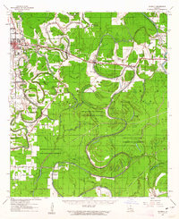 1961 Waverly1963 Print · USGSIn the early 1960s, these Northeast Louisiana parishes were defined by their winding bayous and the reach of the timber industry. Genealogists can trace family roots through several rural churches like Midway Church or Zion Pilgrim No 2 Church and the centrally located Waverly Cem.2 unique versions available
 - 1962 Map of Jackson
 1962 Jackson1962 Print · USGSThe Mississippi Delta and the state capital region are mapped here in the early sixties, showing a landscape defined by the great river and the growing city of JACKSON. Genealogists can trace family roots through numerous landmarks like Cedar Hill Cem, rural stops on the Illinois Central RR, and historic sites like Champion Hill.2 unique versions available
 - 1963 Map of Gretna Green, 1964 Print
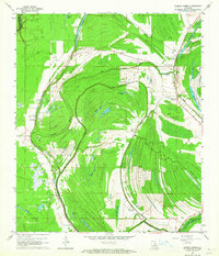 1963 Gretna Green1964 Print · USGSTensas Parish life in the early sixties is centered on the winding waters of Big Choctaw Bayou and its surrounding plantations. Researchers can trace local genealogy through community hubs like Gretna Green and Wavertree Plantation or find old family sites like New China Grove Ch and Mayflower Cem.2 unique versions available
 - 1965 Map of Locust Ridge, 1967 Print
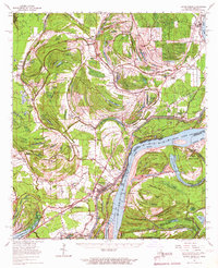 1965 Locust Ridge1967 Print · USGSThe Louisiana-Mississippi riverlands are captured here in the mid-1960s, showing the intricate oxbow lakes and rail-connected settlements along the river's edge. Researchers can locate family-named estates like Winona Plantation and rural landmarks like Choctaw Chapel and the Shiloh Ch.2 unique versions available
End of results
Showing maps 1-5 of 5
Top cities of Franklin Parish
Frequently asked questions
- What are the different types of historical maps available for Franklin Parish?
- What is the oldest map of Franklin Parish?
- Where can I purchase historical maps of Franklin Parish for my home or office?
- Where can I download high-res historical maps of Franklin Parish?
- Are there historical topographic maps available for Franklin Parish?
- Is there historical aerial imagery available for Franklin Parish?
- Where are historical maps of Franklin Parish sourced from?