1970s Maps of St. Gabriel, Louisiana
Explore 2 historic maps of St. Gabriel from the 1970s. These maps offer a rare glimpse into what life looked like during the 1970s — showing old roads, neighborhoods, homes, and landmarks that have changed or disappeared over time.
Whether you're researching your family's past, planning a metal detecting trip, or studying how St. Gabriel's landscape evolved across the 1970s, these high-resolution maps are a powerful tool for exploring the history of this region.
- Focus on a specific era: All maps on this page are from the 1970s, giving you a focused view of this time period.
- See what’s changed: Compare century-old streets, trails, and buildings to today's modern landscape using overlays and satellite layers.
- Research with precision: Use these maps for genealogy, historical research, land use analysis, or educational projects.
- View, download, or print: Maps are fully viewable online in high resolution, and can be downloaded or printed for your own records.
Start exploring St. Gabriel's history through authentic maps from the 1970s. This is your window into the past.
St. Gabriel, LA maps
(2)- 1974 Map of White Castle, 1975 Print
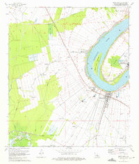 1974 White Castle1975 Print · USGSIberville Parish is captured in the mid-1970s as a bustling corridor of river commerce and agriculture along the Mississippi. Researchers can trace historic settlements like Tally Ho and Samstown, or locate landmarks like the National Leprosarium and Madonna Chapel.2 unique versions available
 - 1974 Map of Carville, 1975 Print
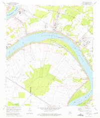 1974 Carville1975 Print · USGSThe Mississippi River meanders through the plantation and industrial corridor of Iberville and Ascension parishes during the mid-seventies. Trace local history at the National Leprosarium and old river landings like Hohen Solms and Philadelphia Point.2 unique versions available
End of results
Showing maps 1-2 of 2
Top cities near St. Gabriel
- Baton Rouge historical maps
- St. George historical maps
- Saint George historical maps
- Prairieville historical maps
- Central historical maps
- Gonzales historical maps
See more
Top neighborhoods of St. Gabriel
- Bruns historical maps
- Carville historical maps
- Rhodes historical maps
- Willow Glen historical maps
- Bayou Paul historical maps
- Sunshine historical maps
See more
Frequently asked questions
- What are the different types of historical maps available for St. Gabriel?
- What is the oldest map of St. Gabriel?
- Where can I purchase historical maps of St. Gabriel for my home or office?
- Where can I download high-res historical maps of St. Gabriel?
- Are there historical topographic maps available for St. Gabriel?
- Is there historical aerial imagery available for St. Gabriel?
- Where are historical maps of St. Gabriel sourced from?