1990s Maps of Jackson Parish, Louisiana
Explore 5 historic maps of Jackson Parish from the 1990s. These maps offer a rare glimpse into what life looked like during the 1990s — showing old roads, neighborhoods, homes, and landmarks that have changed or disappeared over time.
Whether you're researching your family's past, planning a metal detecting trip, or studying how Jackson Parish's landscape evolved across the 1990s, these high-resolution maps are a powerful tool for exploring the history of this region.
- Focus on a specific era: All maps on this page are from the 1990s, giving you a focused view of this time period.
- See what’s changed: Compare century-old streets, trails, and buildings to today's modern landscape using overlays and satellite layers.
- Research with precision: Use these maps for genealogy, historical research, land use analysis, or educational projects.
- View, download, or print: Maps are fully viewable online in high resolution, and can be downloaded or printed for your own records.
Start exploring Jackson Parish's history through authentic maps from the 1990s. This is your window into the past.
Jackson Parish, LA maps
(5)- 1994 Map of Clay
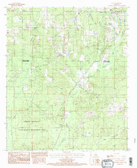 1994 Clay1994 Print · USGSThe intersection of Lincoln and Jackson Parishes in the mid-1990s reveals a landscape shaped by piney woods and bayous. Genealogists can locate several Cem sites near Clay or trace the rural footprint of Woodville and Ansley.
 - 1994 Map of Curr Creek, 1995 Print
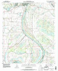
 1994 Curr Creek1995 Print · USGSJackson Parish in the mid-nineties shows a landscape defined by the expansion of the Caney Creek Reservoir. Genealogists and local historians can trace family burial sites at Cem locations or locate the Lookout Tower among the headwaters of Fourmile Creek.
 - 1994 Map of Weston, 1995 Print
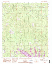
 1994 Weston1995 Print · USGSJackson and Winn Parishes come together in this mid-nineties survey, characterized by the expansion of the Caney Creek Reservoir. Researchers can trace rural life through landmarks like Weston, Walker, and a quiet Cem near the parish line.
 - 1994 Map of Jonesboro South, 1997 Print
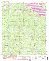
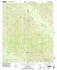
 1994 Jonesboro South1997 Print · USGSLouisiana's delta country at the confluence of the Black and Little Rivers comes into focus in this mid-nineties survey. Genealogists and local historians can locate riverfront settlements like Security and Omega, as well as numerous family-named landmarks like Griffin Cem and Barber Cem.
 - 1998 Map of Vixen, 2003 Print
 1998 Vixen2003 Print · USGSNorthern Louisiana's parish boundaries converge in this late-nineties survey of a landscape defined by timber and winding waterways. Genealogists and local historians can locate the community of Vixen, the historic Seven Runs Crossing, and several local Cem sites.
End of results
Showing maps 1-5 of 5
Top cities of Jackson Parish
- Jonesboro historical maps
- Chatham historical maps
- Hodge historical maps
- North Hodge historical maps
- East Hodge historical maps
- Eros historical maps
See more
Frequently asked questions
- What are the different types of historical maps available for Jackson Parish?
- What is the oldest map of Jackson Parish?
- Where can I purchase historical maps of Jackson Parish for my home or office?
- Where can I download high-res historical maps of Jackson Parish?
- Are there historical topographic maps available for Jackson Parish?
- Is there historical aerial imagery available for Jackson Parish?
- Where are historical maps of Jackson Parish sourced from?