1960s Maps of Jean Lafitte, Louisiana
Explore 6 historic maps of Jean Lafitte from the 1960s. These maps offer a rare glimpse into what life looked like during the 1960s — showing old roads, neighborhoods, homes, and landmarks that have changed or disappeared over time.
Whether you're researching your family's past, planning a metal detecting trip, or studying how Jean Lafitte's landscape evolved across the 1960s, these high-resolution maps are a powerful tool for exploring the history of this region.
- Focus on a specific era: All maps on this page are from the 1960s, giving you a focused view of this time period.
- See what’s changed: Compare century-old streets, trails, and buildings to today's modern landscape using overlays and satellite layers.
- Research with precision: Use these maps for genealogy, historical research, land use analysis, or educational projects.
- View, download, or print: Maps are fully viewable online in high resolution, and can be downloaded or printed for your own records.
Start exploring Jean Lafitte's history through authentic maps from the 1960s. This is your window into the past.
Jean Lafitte, LA maps
(6)- 1962 Map of Barataria, 1966 Print
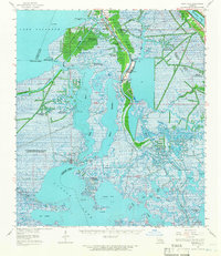 1962 Barataria1966 Print · USGSCoastal Jefferson Parish in the early 1960s reveals a unique intersection of delta settlements and a booming petroleum industry. Genealogists and historians can trace local families through recorded sites like Fleming Cem and Lafitte Cem or the industrial footprint of the Lafitte Oil Field.2 unique versions available
 - 1963 Map of New Orleans
 1963 New Orleans1963 Print · USGSCoastal Louisiana in the mid-twentieth century reveals a complex world of bayou settlements, expanding oil fields, and vital rail networks. Genealogists and historians can trace family roots through river towns like Thibodaux or follow the Southern Pacific line through Franklin and Patterson.4 unique versions available
 - 1966 Map of New Orleans
 1966 New Orleans1966 Print · USGSCoastal Louisiana in the mid-1960s reveals a transition from traditional bayou life to an intensive offshore oil and gas economy. Researchers can trace the rail lines of the Southern Pacific RR through Morgan City or locate the Eugene Island Lighthouse among the delta's shifting marshes.
 - 1966 Map of Lake Cataouatche East, 1967 Print
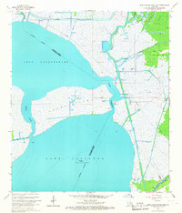 1966 Lake Cataouatche East1967 Print · USGSThe Louisiana wetlands south of New Orleans appear in transition during the mid-sixties as industrial oil fields expanded through the marsh. Trace the dredging of the Millaudon Canal and Estelle Canal or locate old sites like Woods Place.5 unique versions available
 - 1966 Map of Bertrandville, 1967 Print
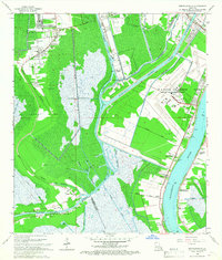 1966 Bertrandville1967 Print · USGSLouisiana's river-and-canal landscape south of New Orleans is captured here during the mid-1960s. Genealogists and historians can trace riverside settlements like Bertrandville and Oakville or locate the sprawling U S Naval Air Station.4 unique versions available
 - 1967 Map of New Orleans, 1969 Print
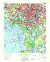 1967 New Orleans1969 Print · USGSGreater New Orleans in the mid-1960s reveals a landscape of massive engineering and urban expansion along the Mississippi River. Genealogists and local historians can trace family roots through the grids of Metairie, Gretna, and Harvey, or locate specific sites like Metairie High Sch and St Vincent de Paul Cem.
End of results
Showing maps 1-6 of 6
Top cities near Jean Lafitte
- New Orleans historical maps
- Kenner historical maps
- Algiers historical maps
- Chalmette historical maps
- Gretna historical maps
- Waggaman historical maps
See more
Top neighborhoods of Jean Lafitte
Frequently asked questions
- What are the different types of historical maps available for Jean Lafitte?
- What is the oldest map of Jean Lafitte?
- Where can I purchase historical maps of Jean Lafitte for my home or office?
- Where can I download high-res historical maps of Jean Lafitte?
- Are there historical topographic maps available for Jean Lafitte?
- Is there historical aerial imagery available for Jean Lafitte?
- Where are historical maps of Jean Lafitte sourced from?