1980s Maps of Ouachita Parish, Louisiana
Explore 18 historic maps of Ouachita Parish from the 1980s. These maps offer a rare glimpse into what life looked like during the 1980s — showing old roads, neighborhoods, homes, and landmarks that have changed or disappeared over time.
Whether you're researching your family's past, planning a metal detecting trip, or studying how Ouachita Parish's landscape evolved across the 1980s, these high-resolution maps are a powerful tool for exploring the history of this region.
- Focus on a specific era: All maps on this page are from the 1980s, giving you a focused view of this time period.
- See what’s changed: Compare century-old streets, trails, and buildings to today's modern landscape using overlays and satellite layers.
- Research with precision: Use these maps for genealogy, historical research, land use analysis, or educational projects.
- View, download, or print: Maps are fully viewable online in high resolution, and can be downloaded or printed for your own records.
Start exploring Ouachita Parish's history through authentic maps from the 1980s. This is your window into the past.
Ouachita Parish, LA maps
(18)- 1982 Map of Chatham
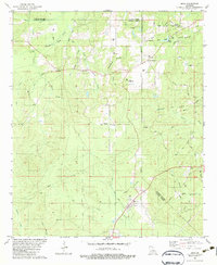
 1982 Chatham1982 Print · USGSJackson Parish in the early eighties centers on the industrial and rail hub of Chatham, where energy production and timber transport define the rural landscape. Genealogists can trace family names through several rural burial sites, including Brooklyn Ch Cem, Wyatt Cem, and Bethel Cem.
 - 1982 Map of Calhoun
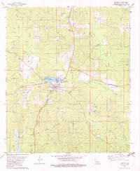
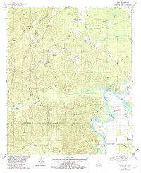
 1982 Calhoun1982 Print · USGSOuachita Parish in the early eighties shows a landscape of petroleum extraction and rural communities. Genealogists can trace family landmarks like Spillers Cem and Aulds Chapel, or explore the rail corridor of the Illinois Central Gulf.
 - 1982 Map of Chatham SE
 1982 Chatham SE1982 Print · USGSThe rural borderlands of Jackson, Ouachita, and Caldwell Parishes come into focus during the early eighties as a landscape of timber and rail. Researchers can trace family-named routes like Sam Brown Road and locate rural landmarks including Phantom Ch and Head Cem.
 - 1982 Map of Cadeville
 1982 Cadeville1982 Print · USGSOuachita Parish communities centered around local timber and gas extraction are captured here in the early eighties. Genealogists can trace family landmarks and rural life through Cadeville, the Wood Cem, and churches like Oak Grove Ch.
 - 1982 Map of Luna
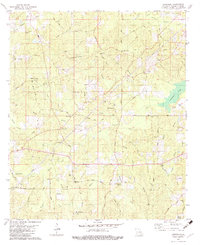
 1982 Luna1982 Print · USGSThe river bottomlands of southern Ouachita Parish come alive in the early eighties as local industry and rural life intersect. Genealogists can trace family roots at St Pauls Cem or Furlow Cem, while mapping the development of the Vixen Gas Field and Fish Hatchery.
 - 1982 Map of Rocky Branch, 1983 Print
 1982 Rocky Branch1983 Print · USGSUnion Parish during the early 1980s reveals a landscape defined by the Monroe Gas Field and the winding Ouachita River. Genealogists and local historians can locate Cook Cem, the community of Rocky Branch, and the old rail corridor of the Missouri Pacific.
 - 1982 Map of Sterlington, 1983 Print
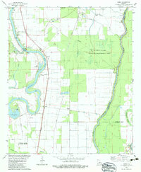
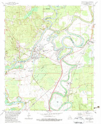 1982 Sterlington1983 Print · USGSSterlington and the Ouachita River valley are shown here in the early eighties as a hub of river industry and parish history. Researchers can locate the Glendora Plantation, trace the Missouri Pacific rail line, and find old burial sites like Bartholomew Cem.
 - 1982 Map of Tallulah, 1983 Print
 1982 Tallulah1983 Print · USGSNortheast Louisiana in the early eighties was a landscape of intricate oxbow lakes and railroad towns. Researchers can trace the heritage of parish centers like Tallulah and Winnsboro, or locate rural landmarks near Yucatan Lake and the Illinois Central Gulf tracks.
 - 1982 Map of Crew Lake, 1983 Print
 1982 Crew Lake1983 Print · USGSRichland Parish in the early eighties was a landscape of managed wetlands and active energy production. Genealogists and researchers can locate family sites like Tharp Cem and Galilee Ch alongside the operations of the Crew Lake Gas Field.
 - 1982 Map of Eros, 1983 Print
 1982 Eros1983 Print · USGSNorth central Louisiana during the early eighties shows a landscape of small timber-and-gas settlements along the parish lines. Researchers can trace family sites like Old Zeigler Cem and Bonett Cem or explore the rural layout of Eros and Indian Village.
 - 1982 Map of Downsville South, 1983 Print
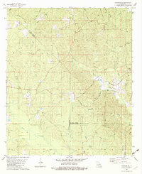
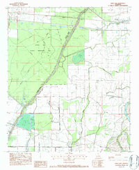
 1982 Downsville South1983 Print · USGSLincoln and Ouachita Parishes in the early eighties were shaped by a busy energy industry and deep-rooted rural communities. Trace family history and land use through Lanes Chapel Cemeteries, the Illinois Central Gulf rail line, and Choudrant School.
 - 1982 Map of Collinston West, 1983 Print
 1982 Collinston West1983 Print · USGSThe Louisiana backcountry of Morehouse Parish in the early eighties is captured here, showing the extensive Monroe Gas Field and river wetlands. Genealogists can trace family names at the Carter Cem, Ebenezer Ch, and the high ground of Trouser Hill.
 - 1982 Map of Bosco, 1983 Print
 1982 Bosco1983 Print · USGSNortheastern Louisiana at the start of the eighties shows a landscape of river bends and bayous bordering the Ouachita State Wildlife Management Area. Researchers can trace local roots at Logtown, Bosco, and Fondale, or find family landmarks like Faulks Cem and Cuba Ch.
 - 1982 Map of Bastrop, 1983 Print
 1982 Bastrop1983 Print · USGSNortheastern Louisiana and the Mississippi River Delta are captured here in the early eighties as a landscape of bayous and river towns. Genealogists and historians can trace small communities like Mer Rouge and Oak Grove or the ancient terrain of Poverty Point State Park.
 - 1982 Map of Swartz, 1983 Print
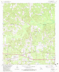
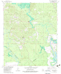
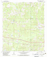
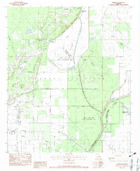 1982 Swartz1983 Print · USGSIn the early eighties, this corner of Ouachita Parish was a hub of natural gas extraction and conservation efforts. Researchers can trace rural lineages through Wham Cem, family roads like Stubbs-Ritchie Road, and landmarks like Bethel Ch.
 - 1984 Map of Shreveport
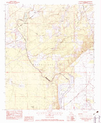
 1984 Shreveport1984 Print · USGSNorthern Louisiana at the peak of the 1980s reveals a landscape of massive water management projects and Cold War military hubs. Trace the rail lines of the Kansas City Southern Ry past Barksdale Air Force Base and the high ground of Driskill Mountain.2 unique versions available
 - 1985 Map of Monroe South
 1985 Monroe South1985 Print · USGSNorth Central Louisiana in the mid-1980s was a hub of timber production and rail transport spanning from the Dugdemona River to the Ouachita valley. Family researchers and historians can trace the rail lines of the Midsouth Railroad through Jonesboro or find local landmarks like Mineral Springs and Punkin Center.2 unique versions available
 - 1985 Map of Monroe North, 1986 Print
 1985 Monroe North1986 Print · USGSNorth-central Louisiana in the mid-eighties was a landscape defined by the growth of university towns and the expansion of the natural gas industry. Researchers can trace rural family roots through landmarks like Lisbon Cem, New Hope Ch, and the many schools in Farmerville or Bernice.2 unique versions available
End of results
Showing maps 1-18 of 18
Top cities of Ouachita Parish
- Monroe historical maps
- West Monroe historical maps
- Claiborne historical maps
- Swartz historical maps
- Richwood historical maps
- Sterlington historical maps
Frequently asked questions
- What are the different types of historical maps available for Ouachita Parish?
- What is the oldest map of Ouachita Parish?
- Where can I purchase historical maps of Ouachita Parish for my home or office?
- Where can I download high-res historical maps of Ouachita Parish?
- Are there historical topographic maps available for Ouachita Parish?
- Is there historical aerial imagery available for Ouachita Parish?
- Where are historical maps of Ouachita Parish sourced from?