1990s Maps of Ouachita Parish, Louisiana
Explore 12 historic maps of Ouachita Parish from the 1990s. These maps offer a rare glimpse into what life looked like during the 1990s — showing old roads, neighborhoods, homes, and landmarks that have changed or disappeared over time.
Whether you're researching your family's past, planning a metal detecting trip, or studying how Ouachita Parish's landscape evolved across the 1990s, these high-resolution maps are a powerful tool for exploring the history of this region.
- Focus on a specific era: All maps on this page are from the 1990s, giving you a focused view of this time period.
- See what’s changed: Compare century-old streets, trails, and buildings to today's modern landscape using overlays and satellite layers.
- Research with precision: Use these maps for genealogy, historical research, land use analysis, or educational projects.
- View, download, or print: Maps are fully viewable online in high resolution, and can be downloaded or printed for your own records.
Start exploring Ouachita Parish's history through authentic maps from the 1990s. This is your window into the past.
Ouachita Parish, LA maps
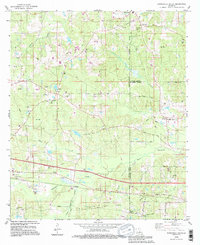
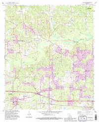
(12)- 1994 Map of Sterlington, 1995 Print
 1994 Sterlington1995 Print · USGSThe industrial corridor along the Ouachita River comes into focus in the mid-nineties, showing the intersection of heavy industry and parish history. Trace old family roots and rural landmarks at Glendora Plantation, Ouachita City, and several cemeteries including Bartholomew Cem.
 - 1994 Map of Swartz, 1995 Print
 1994 Swartz1995 Print · USGSNorth of Monroe in the mid-nineties, this survey captures an era when energy production and wildlife conservation shared the Louisiana landscape. Local historians can trace old family sites like Wham Cem and small settlements like Puckettville and Swartz.
 - 1994 Map of Collinston West, 1995 Print
 1994 Collinston West1995 Print · USGSThe Morehouse Parish backcountry near the end of the century reveals a landscape shaped by the Monroe Gas Field and expansive wetlands. Researchers can trace family sites at Pickett Cem, the Fairbanks Lookout Tower, and Spyker.
 - 1994 Map of West Monroe South, 1995 Print
 1994 West Monroe South1995 Print · USGSThe Ouachita River valley south of West Monroe comes into focus during the mid-nineties as suburban growth meets the bayou landscape. Trace family history at Old Sardis Cem, Behy Cem, and Woodlawn Sch while exploring the banks of Cheniere Brake.
 - 1994 Map of Downsville South, 1995 Print
 1994 Downsville South1995 Print · USGSLincoln Parish at the end of the twentieth century shows a landscape defined by its timbered hills and the expanding gas industry. Genealogists and local historians can locate several family landmarks and congregations, including Lanes Chapel Cems, the Saints Rest Ch Cem, and the community at Sibley.
 - 1994 Map of Monroe North, 1995 Print
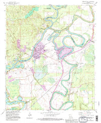
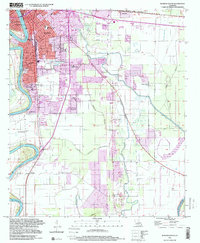
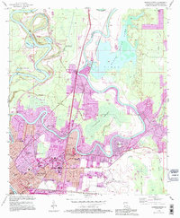 1994 Monroe North1995 Print · USGSMonroe and its northern bayous are captured here in the mid-1990s, showcasing a landscape of winding river loops and growing neighborhoods. Genealogists and local historians can trace landmarks like NE Louisiana State College, St Matthew Cem, and the old Selman Airport.
 - 1994 Map of West Monroe North, 1995 Print
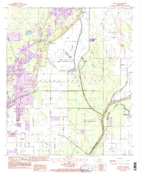
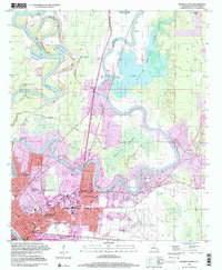
 1994 West Monroe North1995 Print · USGSWest Monroe and the surrounding bayous are captured here in the mid-nineties during a period of suburban expansion and industrial activity. Genealogists and local historians can locate family landmarks like Hasley Cem, Goodhope Ch, and the vanished Drive-in Theater.
 - 1994 Map of Monroe South, 1995 Print
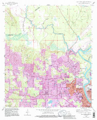
 1994 Monroe South1995 Print · USGSThe Ouachita River corridor south of Monroe shows a region of suburban growth and vast wildlife preserves in the mid-nineties. Trace local landmarks like the Louisiana Training Institute, Gibson Chapel, and Ballard Cem.
 - 1994 Map of Calhoun, 1995 Print
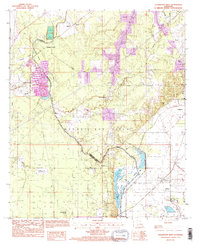
 1994 Calhoun1995 Print · USGSLouisiana's rolling interior at the edge of the D'Arbonne basin is captured here as a landscape of timber, agriculture, and oil. Genealogists and local historians can trace rural family roots through landmarks like Mt Zion Cem, Aulds Chapel, and the North Louisiana Experimental Station.
 - 1999 Map of Monroe South, 2000 Print
 1999 Monroe South2000 Print · USGSThe Ouachita River corridor at the end of the century reveals the growth of Monroe and its southern outskirts. Trace family history and land patterns through New City Cemetery, Shady Grove Sch, and the rail lines of the Illinois Central Railroad.
 - 1999 Map of Monroe North, 2001 Print
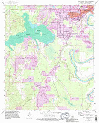
 1999 Monroe North2001 Print · USGSMonroe and its surrounding wetlands are captured here at the close of the twentieth century. Researchers can trace the development of NE Louisiana State College and locate numerous family landmarks including St Matthew Cem and the Lakeshore Sch.
 - 1999 Map of West Monroe North, 2001 Print
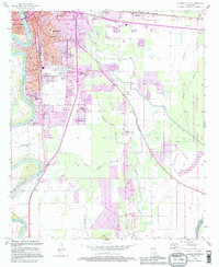
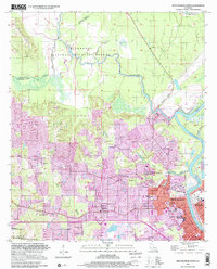 1999 West Monroe North2001 Print · USGSNorth Ouachita Parish at the end of the twentieth century shows a landscape where the D'Arbonne National Wildlife Refuge meets the expanding urban footprint of WEST MONROE. Researchers can trace local genealogy and civic history through sites like Hasley Cem, Boley High Sch, and Mt Horeb Ch.
End of results
Showing maps 1-12 of 12
Top cities of Ouachita Parish
- Monroe historical maps
- West Monroe historical maps
- Claiborne historical maps
- Swartz historical maps
- Richwood historical maps
- Sterlington historical maps
Frequently asked questions
- What are the different types of historical maps available for Ouachita Parish?
- What is the oldest map of Ouachita Parish?
- Where can I purchase historical maps of Ouachita Parish for my home or office?
- Where can I download high-res historical maps of Ouachita Parish?
- Are there historical topographic maps available for Ouachita Parish?
- Is there historical aerial imagery available for Ouachita Parish?
- Where are historical maps of Ouachita Parish sourced from?