Old Maps of Monroe, Louisiana for Hiking & Exploration
Hike through history with 63 historic maps of Monroe. Explore old trails, ghost towns, and forgotten backroads — perfect for outdoor adventurers and local explorers.
- Rediscover forgotten places: Map out old mining camps, roads, and footpaths that no longer exist on modern maps.
- Layer with modern tools: Combine with LiDAR or satellite views to plan hikes through historical terrain.
- Made for exploration: Popular among hikers, overlanders, and local history lovers.
Use these maps to find adventure and explore the hidden past of Monroe.
Monroe, LA maps
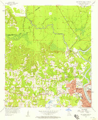
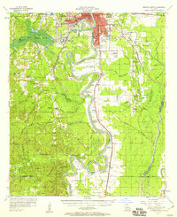
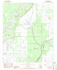
(63)- 1935 Map of Collinston
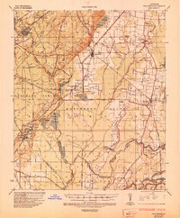 1935 Collinston1935 Print · USGSMorehouse and Ouachita Parishes are seen here in the mid-1930s during a period of heavy industrialization fueled by the natural gas boom. Researchers can trace the sprawling footprints of the Southern Carbon Co and find rural landmarks like Jerusalem Ch and the Indian Mounds.
 - 1935 Map of Alto, 1936 Print
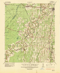 1935 Alto1936 Print · USGSRichland Parish in the mid-1930s shows a landscape of river-bottom agriculture and an early industrial energy boom. Researchers can trace the legacy of local river travel at Douciere Ferry and locate commercial sites like Rhymes Store or the Century Carbon Company.2 unique versions available
 - 1935 Map of Drew, 1947 Print
 1935 Drew1947 Print · USGSNorthern Louisiana's river country was defined by winding waterways and emerging energy infrastructure in the 1930s. Genealogists can trace early crossings like Whites Ferry and family-named locales such as Guthrie or the Childrens Home in Monroe.
 - 1940 Map of Monroe, 1942 Print
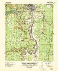 1940 Monroe1942 Print · USGSThe Ouachita River valley at the onset of the 1940s shows a landscape defined by its waterways and burgeoning river towns. Genealogists and historians can trace family roots through numerous country landmarks like Logtown Ch, Faulks Sch, and the La Training Institute for Boys.2 unique versions available
 - 1955 Map of Jackson
 1955 Jackson1955 Print · USGSThe Lower Mississippi Valley at the middle of the century reveals a landscape of deep river meanders and growing rail hubs. Genealogists and historians can trace the mid-century footprints of Vicksburg National Military Park, old river landings at Port Gibson, and the rail corridors of the Illinois Central Railroad.3 unique versions available
 - 1955 Map of Shreveport
 1955 Shreveport1955 Print · USGSNorthern Louisiana in the mid-fifties is captured here as a landscape of military bases, vast oil fields, and burgeoning college towns. Genealogists and historians can trace the rail-and-river economy through the Monroe Gas Field, Grambling College, and Barksdale Air Force Base.3 unique versions available
 - 1956 Map of Shreveport
 1956 Shreveport1956 Print · USGSNorthern Louisiana during the mid-fifties presents a complex landscape of booming oil fields and strategic military installations. Genealogists and historians can trace the infrastructure of the Monroe Gas Field and family-named locales from Cotton Valley to Jonesboro.
 - 1957 Map of Monroe North, 1958 Print
 1957 Monroe North1958 Print · USGSNorth of the city center in the late fifties, the riverfront and bayous define a landscape of growing neighborhoods and industrial sites. Researchers can trace family roots through landmarks like Bean Chapel, Neville High Sch, and the grounds of Selman Airport.2 unique versions available
 - 1957 Map of West Monroe North, 1958 Print
 1957 West Monroe North1958 Print · USGSWest Monroe and its northern rural reaches are captured here during a period of steady mid-century development. Researchers can trace ancestral footprints at Hasley Cem, locate rural landmarks like Goodhope Ch, or follow the Illinois Central rail line through the bayou country.4 unique versions available
 - 1957 Map of Mangham, 1958 Print
 1957 Mangham1958 Print · USGSRichland and Franklin Parishes in the late fifties reveal a landscape of river-bottom agriculture and small rail towns. Genealogists can trace family roots through numerous local landmarks like Rhymes High Sch, St Luke Cem, and Mt Zion Ch.3 unique versions available
 - 1957 Map of West Monroe South, 1958 Print
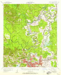
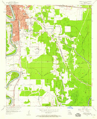
 1957 West Monroe South1958 Print · USGSOuachita Parish in the late fifties shows a landscape defined by the winding Ouachita River and the vast Cheniere Brake wetlands. Researchers can trace family sites at Old Sardis Cem or locate former landmarks like the Drive-in Theater and Woodlawn Sch.4 unique versions available
 - 1957 Map of Monroe South, 1958 Print
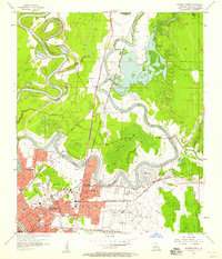
 1957 Monroe South1958 Print · USGSOuachita Parish at the peak of the 1950s reveals a bustling riverfront economy and expanding neighborhoods. Genealogists and local historians can trace the foundations of West Monroe and rural landmarks like Old St James Ch and Ballard Cem.5 unique versions available
 - 1957 Map of Monroe South, 1958 Print
 1957 Monroe South1958 Print · USGSThe southern Ouachita Parish riverlands are captured here in the late fifties, showcasing a landscape of deep river bends and rural crossroads. Genealogists and researchers can locate ancestral sites like the Furlough Cemetery, Bawcomville, and the Union School along the Ouachita River banks.3 unique versions available
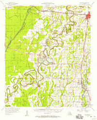
 - 1957 Map of Collinston, 1958 Print
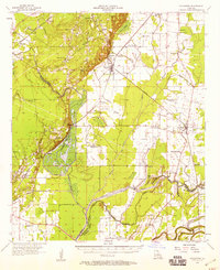 1957 Collinston1958 Print · USGSMorehouse and Richland Parishes are shown in the late fifties, featuring the transition from agricultural bayous to active gas fields. Genealogists can locate family landmarks like Cedar Grove Sch, William Chapel, and the ancient Indian Mounds near Oak Ridge.3 unique versions available
 - 1957 Map of Monroe North, 1958 Print
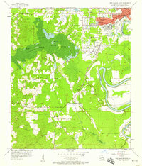
 1957 Monroe North1958 Print · USGSMonroe and the Ouachita River valley are captured in the late fifties as the city expanded northward toward the gas fields. Researchers can trace local history through NE Louisiana State College, Selman Airport, and family landmarks like Cosper Cem.4 unique versions available
 - 1961 Map of Jackson
 1961 Jackson1961 Print · USGSThe Lower Mississippi Delta and the state capital area are captured here during the post-war era of infrastructure expansion. Researchers can trace the complex river oxbows and rail lines connecting Vicksburg, Yazoo City, and the Illinois Central Railroad network.
 - 1962 Map of Jackson
 1962 Jackson1962 Print · USGSThe Mississippi Delta and the state capital region are mapped here in the early sixties, showing a landscape defined by the great river and the growing city of JACKSON. Genealogists can trace family roots through numerous landmarks like Cedar Hill Cem, rural stops on the Illinois Central RR, and historic sites like Champion Hill.2 unique versions available
 - 1969 Map of Monroe North
 1969 Monroe North1969 Print · USGSMonroe and West Monroe enter a period of rapid growth during the late sixties as urban development pushes into the surrounding bayous. Genealogists can trace family names and local sites from Northeast Louisiana State College to the quiet grounds of Memorial Park Cem and rural Ouachita City.
 - 1982 Map of Tallulah, 1983 Print
 1982 Tallulah1983 Print · USGSNortheast Louisiana in the early eighties was a landscape of intricate oxbow lakes and railroad towns. Researchers can trace the heritage of parish centers like Tallulah and Winnsboro, or locate rural landmarks near Yucatan Lake and the Illinois Central Gulf tracks.
 - 1982 Map of Crew Lake, 1983 Print
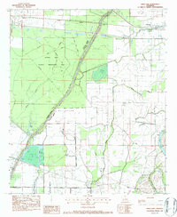 1982 Crew Lake1983 Print · USGSRichland Parish in the early eighties was a landscape of managed wetlands and active energy production. Genealogists and researchers can locate family sites like Tharp Cem and Galilee Ch alongside the operations of the Crew Lake Gas Field.
 - 1982 Map of Bastrop, 1983 Print
 1982 Bastrop1983 Print · USGSNortheastern Louisiana and the Mississippi River Delta are captured here in the early eighties as a landscape of bayous and river towns. Genealogists and historians can trace small communities like Mer Rouge and Oak Grove or the ancient terrain of Poverty Point State Park.
 - 1982 Map of Swartz, 1983 Print
 1982 Swartz1983 Print · USGSIn the early eighties, this corner of Ouachita Parish was a hub of natural gas extraction and conservation efforts. Researchers can trace rural lineages through Wham Cem, family roads like Stubbs-Ritchie Road, and landmarks like Bethel Ch.
 - 1984 Map of Shreveport
 1984 Shreveport1984 Print · USGSNorthern Louisiana at the peak of the 1980s reveals a landscape of massive water management projects and Cold War military hubs. Trace the rail lines of the Kansas City Southern Ry past Barksdale Air Force Base and the high ground of Driskill Mountain.2 unique versions available
 - 1985 Map of Monroe South
 1985 Monroe South1985 Print · USGSNorth Central Louisiana in the mid-1980s was a hub of timber production and rail transport spanning from the Dugdemona River to the Ouachita valley. Family researchers and historians can trace the rail lines of the Midsouth Railroad through Jonesboro or find local landmarks like Mineral Springs and Punkin Center.2 unique versions available
 - 1985 Map of Monroe North, 1986 Print
 1985 Monroe North1986 Print · USGSNorth-central Louisiana in the mid-eighties was a landscape defined by the growth of university towns and the expansion of the natural gas industry. Researchers can trace rural family roots through landmarks like Lisbon Cem, New Hope Ch, and the many schools in Farmerville or Bernice.2 unique versions available
Showing maps 1-25 of 63
Top cities near Monroe
- West Monroe historical maps
- Claiborne historical maps
- Bastrop historical maps
- Swartz historical maps
- Richwood historical maps
- Sterlington historical maps
See more
Top neighborhoods of Monroe
- Kings Oaks historical maps
- Magenta historical maps
- Robinson Place historical maps
- East Parkview historical maps
- Fish Creek historical maps
- Forest Home historical maps
See more
Frequently asked questions
- What are the different types of historical maps available for Monroe?
- What is the oldest map of Monroe?
- Where can I purchase historical maps of Monroe for my home or office?
- Where can I download high-res historical maps of Monroe?
- Are there historical topographic maps available for Monroe?
- Is there historical aerial imagery available for Monroe?
- Where are historical maps of Monroe sourced from?