Old Maps of Port Eads, Louisiana for Academic Research
Study the evolution of Port Eads with 14 high-resolution historic maps. Whether you're teaching, researching, or modeling changes in land use, these maps provide essential visual documentation of urban, environmental, and geographic change.
- Analyze long-term change: Track patterns in development, transportation, and natural features.
- Ideal for environmental or urban studies: Support academic projects with primary historical map data.
- Use in the classroom or lab: Educators and researchers rely on these maps to bring historical context to life.
These maps are a powerful tool for teaching, research, and visualizing how Port Eads has changed over the decades.
Port Eads, LA maps
(14)- 1893 Map of East Delta
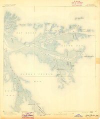 1893 East Delta1893 Print · USGSThe tip of the Mississippi River delta comes alive in the 1890s, where river pilots and maritime outposts guarded the gateway to the Gulf. Genealogists and historians can trace the foundations of Port Eads and Balize, or locate the Old Spanish Magazine and the early South Pass Light.6 unique versions available
 - 1935 Map of South Pass
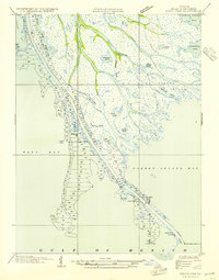 1935 South Pass1935 Print · USGSThe Mississippi River Delta reaches into the Gulf during the 1930s, showing a landscape of delicate marshland and engineered channels. Local historians can trace the maritime operations at Port Eads and locate coastal landmarks like South Pass L H and the Pilot Sta.3 unique versions available
 - 1954 Map of East Delta
 1954 East Delta1954 Print · USGSThe Mississippi River's mouth in the mid-fifties reveals a specialized coastal landscape of maritime pilots and oil exploration. Trace the isolated settlement at Port Eads, see the South Pass Pilot Station, and locate the Delta Duck Oil Field among the marshy passes.
 - 1957 Map of Breton Sound, 1967 Print
 1957 Breton Sound1967 Print · USGSThe Mississippi River delta is captured here in the mid-fifties, showing the fragile marshlands and river-dependent towns of the Louisiana coast. Genealogists and historians can trace riverside settlements like Pointe a la Hache, Pilottown, and Port Sulphur.3 unique versions available
 - 1958 Map of East Delta, 1961 Print
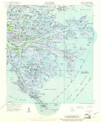 1958 East Delta1961 Print · USGSThe Mississippi River delta in the late fifties shows a complex landscape of marshland and maritime industry. Researchers can trace remote outposts like Port Eads and mid-century energy development at the Delta Duck Oil Field and Block 30 Gas Field.2 unique versions available
 - 1961 Map of Breton Sound
 1961 Breton Sound1961 Print · USGSThe Louisiana delta and the outer marshes of Plaquemines Parish are captured here at the start of the 1960s. Researchers can trace the river settlements from Davant to Venice, locate isolated stations like Port Eads, and find old sites such as Fort Jackson.
 - 1971 Map of South Pass, 1974 Print
 1971 South Pass1974 Print · USGSThe tip of the Mississippi Delta in the early seventies shows a landscape where industrial infrastructure meets the coastal marsh. Researchers can trace the layout of Port Eads, find the isolated Clubhouse, and locate remote energy sites like the Block 27 Oil Field.2 unique versions available
 - 1983 Map of Mississippi River Delta
 1983 Mississippi River Delta1983 Print · USGSThe lower Mississippi delta in the early eighties shows the thin line of human habitation clinging to the river levee between the vast marshes and the gulf. Genealogists and historians can trace the riverside communities of Empire, Triumph, and Nairn alongside the industrial Sulphur Mining Area.2 unique versions available
 - 1998 Map of South Pass, 2003 Print
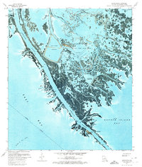
 1998 South Pass2003 Print · USGSThe Louisiana delta reveals its complex industrial and natural landscape in the late nineties, centered on the Port Eads settlement. Researchers can trace the intersection of the Oil and Gas Field with the State Waterfowl Management Area.
 - 2012 Map of South Pass, 2012 Print
 2012 South Pass2012 Print · USGSCovers Port Eads, including Plaquemines Parish, United States, and other nearby areas
 - 2015 Map of South Pass, 2015 Print
 2015 South Pass2015 Print · USGSCovers Port Eads, including Plaquemines Parish, United States, and other nearby areas
 - 2018 Map of South Pass, 2018 Print
 2018 South Pass2018 Print · USGSCovers Port Eads, including Plaquemines Parish, United States, and other nearby areas
 - 2020 Map of South Pass, 2020 Print
 2020 South Pass2020 Print · USGSCovers Port Eads, including Plaquemines Parish, United States, and other nearby areas
 - 2024 Map of South Pass, 2024 Print
 2024 South Pass2024 Print · USGSThe tip of the Mississippi River delta comes into focus in the early 2020s, showing the fragile marshlands where the river meets the sea. Trace the water-bound settlement of Port Eads and the complex waterways of South Pass and Dennis Pass.
End of results
Showing maps 1-14 of 14
Frequently asked questions
- What are the different types of historical maps available for Port Eads?
- What is the oldest map of Port Eads?
- Where can I purchase historical maps of Port Eads for my home or office?
- Where can I download high-res historical maps of Port Eads?
- Are there historical topographic maps available for Port Eads?
- Is there historical aerial imagery available for Port Eads?
- Where are historical maps of Port Eads sourced from?