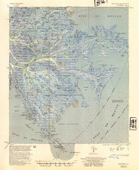
1954 Map of East Delta
USGS Topo · Published 1954About this map
The dynamic Mississippi River delta in the early 1950s is defined here by its complex network of distributaries, where Pass a Loutre, South Pass, and North Pass fan out into the Gulf of Mexico. This coastal landscape in Plaquemines Parish shows a heavy industrial presence alongside conservation efforts, with the Delta Duck Oil Field and Garden Island Bay Oil Field operating near the Delta National Wildlife Refuge. The map provides a look at maritime infrastructure of the era, including the South Pass Pilot Station at Port Eads and the Northeast Pass Lighthouse Tower. Beyond the primary channels, smaller features like Rigaud Ridge and Bastian Lake break up the marshlands, while the Freeport Sulphur Co and various underground pipes indicate the mid-century extraction economy driving the region's development.
Find a feature on this map
122 named features on this map. Tap any name to fly to it.
Don’t see what you’re looking for? This feature index may not catch every label — zoom into the map to look around manually.
Map Details
Editions of this 1954 East Delta Map
This is the sole edition of this map. No revisions or reprints were ever made.
Other maps of this area

1893 · East Delta
USGS Topo · 1:62,500

1893 · Forts
USGS Topo · 1:62,500

1893 · West Delta
USGS Topo · 1:62,500

1935 · Garden Island Pass
USGS Topo · 1:31,680

1935 · South Pass
USGS Topo · 1:31,680

1946 · Mudpan Bayou
USGS Topo · 1:31,680

1947 · Garden Island Pass
USGS Topo · 1:31,680

1947 · Pass A Loutre West
USGS Topo · 1:31,680

1947 · Venice
USGS Topo · 1:31,680

1947 · Southwest Pass
USGS Topo · 1:31,680