1940s Maps of St. Charles Parish, Louisiana
Explore 10 historic maps of St. Charles Parish from the 1940s. These maps offer a rare glimpse into what life looked like during the 1940s — showing old roads, neighborhoods, homes, and landmarks that have changed or disappeared over time.
Whether you're researching your family's past, planning a metal detecting trip, or studying how St. Charles Parish's landscape evolved across the 1940s, these high-resolution maps are a powerful tool for exploring the history of this region.
- Focus on a specific era: All maps on this page are from the 1940s, giving you a focused view of this time period.
- See what’s changed: Compare century-old streets, trails, and buildings to today's modern landscape using overlays and satellite layers.
- Research with precision: Use these maps for genealogy, historical research, land use analysis, or educational projects.
- View, download, or print: Maps are fully viewable online in high resolution, and can be downloaded or printed for your own records.
Start exploring St. Charles Parish's history through authentic maps from the 1940s. This is your window into the past.
St. Charles Parish, LA maps
(10)- 1940 Map of Allemands
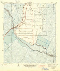 1940 Allemands1940 Print · USGSCoastal Louisiana marshlands and reclaimed swamps are frozen in time just before the mid-century, centered on the railroad crossing at Des Allemands Sta. Genealogists and historians can trace the grid of the Crawford Canal and locate the St. Charles Sch along the Southern Pacific tracks.2 unique versions available
 - 1941 Map of Cut-Off
 1941 Cut-Off1941 Print · USGSCoastal Lafourche Parish is captured here just before the mid-century, showing the reclaimed wetlands and bayou-side life. Genealogists can trace family settlements at Larose, Valentine, and Gheens, or locate sites like Sacred Heart Ch and Bourgeois Sch.2 unique versions available
 - 1941 Map of Barataria
 1941 Barataria1941 Print · USGSCoastal Jefferson Parish appears at the dawn of the 1940s, where the Mississippi River meets a vast network of bayous and wetlands. Genealogists can trace family roots in Barataria and Jesuit Bend, or locate historic local landmarks like Fisher Sch No 1 and the Lafitte P O.
 - 1941 Map of Lac Des Allemands
 1941 Lac Des Allemands1941 Print · USGSLafourche Parish at the start of the 1940s reveals a water-bound economy of bayous, swamps, and sugar plantations. Genealogists and researchers can trace local church and school sites like St Lawrence Ch and Choctaw Sch alongside historic holdings such as Melodia Plantation.
 - 1942 Map of Lake Cataouatche West
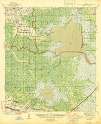
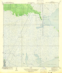 1942 Lake Cataouatche West1942 Print · USGSCoastal St. Charles Parish appears as a labyrinth of wetlands and industrial canals in the years before mid-century. Researchers can trace early drainage efforts in the New Orleans Netherlands Drainage District or follow the route of the Louisiana Cypress Lumber Canal.
 - 1942 Map of Lake Cataouatche East
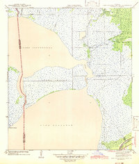 1942 Lake Cataouatche East1942 Print · USGSCoastal Jefferson and St. Charles Parishes are revealed in the early 1940s, documenting a landscape of expansive lakes and intricate bayous. Historians can trace early navigation routes through the Intracoastal Waterway and identify remote settlements like Bouquet des Chenes near Couba Island.
 - 1944 Map of Barataria
 1944 Barataria1944 Print · USGSCoastal Jefferson Parish appears as a intricate network of tidal bayous and marshes in the years during World War II. Genealogists and historians can trace the early settlement footprints of Lafitte P O, Villere, and the local Fisher Sch No 1.
 - 1944 Map of Lac Des Allemands
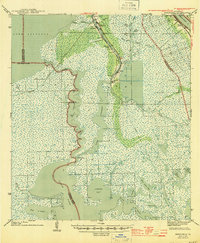
 1944 Lac Des Allemands1944 Print · USGSThe swampy interface of St. James and Lafourche parishes comes alive in this mid-century survey of the Mississippi River delta. Genealogists can trace family roots at Golden Star Plantation, Webster Plantation, and community landmarks like St Lawrence Ch.2 unique versions available
 - 1945 Map of New Orleans
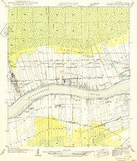
 1945 New Orleans1945 Print · USGSCoastal Louisiana and the Mississippi delta are captured here just after the war, showing the region's transition into a modern industrial and transit hub. Genealogists can trace family settlements along Bayou Teche or identify rail stops for the Illinois Central and Texas & Pacific lines.
 - 1949 Map of Garyville
 1949 Garyville1949 Print · USGSThe Mississippi River corridor comes alive in the late 1940s, showing the intersection of rail-and-river commerce and deep-rooted sugar parishes. Trace ancestral roots and industrial history through the Columbia Sugar Mill, St Peters Ch, and the Illinois Central railroad line.
End of results
Showing maps 1-10 of 10
Frequently asked questions
- What are the different types of historical maps available for St. Charles Parish?
- What is the oldest map of St. Charles Parish?
- Where can I purchase historical maps of St. Charles Parish for my home or office?
- Where can I download high-res historical maps of St. Charles Parish?
- Are there historical topographic maps available for St. Charles Parish?
- Is there historical aerial imagery available for St. Charles Parish?
- Where are historical maps of St. Charles Parish sourced from?