1950s Maps of St. Charles Parish, Louisiana
Explore 14 historic maps of St. Charles Parish from the 1950s. These maps offer a rare glimpse into what life looked like during the 1950s — showing old roads, neighborhoods, homes, and landmarks that have changed or disappeared over time.
Whether you're researching your family's past, planning a metal detecting trip, or studying how St. Charles Parish's landscape evolved across the 1950s, these high-resolution maps are a powerful tool for exploring the history of this region.
- Focus on a specific era: All maps on this page are from the 1950s, giving you a focused view of this time period.
- See what’s changed: Compare century-old streets, trails, and buildings to today's modern landscape using overlays and satellite layers.
- Research with precision: Use these maps for genealogy, historical research, land use analysis, or educational projects.
- View, download, or print: Maps are fully viewable online in high resolution, and can be downloaded or printed for your own records.
Start exploring St. Charles Parish's history through authentic maps from the 1950s. This is your window into the past.
St. Charles Parish, LA maps
(14)- 1950 Map of New Orleans, 1966 Print
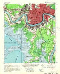
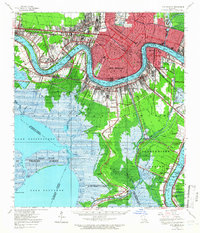 1950 New Orleans1966 Print · USGSMid-century New Orleans and its surrounding bayous are captured here at a peak of rail and river industry. Genealogists and historians can trace family roots through riverside settlements like McDonoghville and Arabi or locate landmarks like Olive Branch Cem and Rosethorn Sch.
 - 1951 Map of Luling, 1953 Print
 1951 Luling1953 Print · USGSIn the early fifties, the Mississippi River corridor between Luling and Kenner served as a vital industrial and transport hub. Genealogists and historians can trace old community lines and landmarks like Lone Star, St Rose, and the historic Davis Crevasse of 1884.2 unique versions available
 - 1951 Map of New Orleans West, 1953 Print
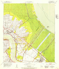
 1951 New Orleans West1953 Print · USGSMid-century Jefferson Parish is captured here at a peak of rail and aviation expansion along the Mississippi. Researchers can trace the early footprint of Moisant Airport and locate vanished local landmarks like Deckbar Sch and Pricetown.2 unique versions available
 - 1952 Map of Laplace, 1953 Print
 1952 Laplace1953 Print · USGSIn the early fifties, this area of the river parishes was defined by the intersection of industrial growth and massive flood control projects. Researchers can trace the riverfront footprints of Glen Dale Plantation and the Old Killona Sch alongside the sprawling Bonnet Carre Floodway.
 - 1952 Map of Allemands, 1953 Print
 1952 Allemands1953 Print · USGSThe Louisiana bayou country is captured here during the mid-century expansion of the energy industry. Researchers can trace family sites like Shell Mound Cem, see the early Paradis Oil Field, and follow the Southern Pacific line through Allemands.2 unique versions available
 - 1952 Map of Hahnville, 1953 Print
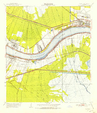
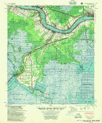
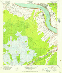 1952 Hahnville1953 Print · USGSMid-century St. Charles Parish shows a landscape balancing the Mississippi River industry with the vast wetlands of the Paradis Oil Field. Genealogists can trace family roots through riverfront settlements and find landmarks like St Charles Cem, Mt Airy Ch, and the Paradis Sch.2 unique versions available
 - 1952 Map of Lake Cataouatche West, 1953 Print
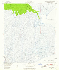 1952 Lake Cataouatche West1953 Print · USGSThe Louisiana wetlands in the early fifties show a landscape of industrial drainage and petroleum exploration. Researchers can trace the mid-century oil infrastructure at Bayou Couba Oil Field or follow timber routes like the Louisiana Cypress Lumber Canal.2 unique versions available
 - 1952 Map of La Branche, 1953 Print
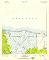 1952 La Branche1953 Print · USGSThe St. Charles Parish shoreline at mid-century reveals a landscape of industrial marshland and massive flood control projects. Historians can trace the Illinois Central rail line through the wetlands, past an Oil Field and the Bonnet Carre Floodway.2 unique versions available
 - 1952 Map of Lake Cataouatche East, 1953 Print
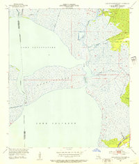 1952 Lake Cataouatche East1953 Print · USGSCoastal Louisiana marshes and vital waterways are captured here in the early fifties, showing the transition from natural bayous to industrial channels. Researchers can trace the development of the Bayou Couba Oil Field and old canal systems like Millaudon Canal.2 unique versions available
 - 1954 Map of New Orleans, 1955 Print
 1954 New Orleans1955 Print · USGSMid-century New Orleans and its surrounding parishes are shown here during a period of significant industrial and suburban expansion. Genealogists and researchers can locate neighborhood landmarks like Olive Branch Cem, early aviation hubs like Moisant Airport, and riverfront communities from McDonoghville to Bertrandville.
 - 1954 Map of Baton Rouge, 1974 Print
 1954 Baton Rouge1974 Print · USGSSoutheast Louisiana in the mid-fifties is captured here during a period of transition for its river and rail economies. Researchers can trace the path of the Mississippi River and find landmarks like the Bonnet Carre Spillway and Bayou Plaquemine.2 unique versions available
 - 1955 Map of Hahnville
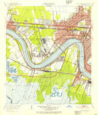
 1955 Hahnville1955 Print · USGSSt. Charles Parish in the mid-1950s shows a landscape balancing river industry with vast coastal wetlands. Genealogists and historians can trace the development of Hahnville and Destrehan or locate rural landmarks like Mt Airy Church and the Davis Crevasse of 1884.
 - 1956 Map of Baton Rouge
 1956 Baton Rouge1956 Print · USGSSouth Louisiana at the height of the mid-century oil boom shows a landscape of river oxbows and rising industry. Researchers can trace family roots through river towns like Scotlandville or locate early industrial sites and Oil wells near Lake Maurepas.
 - 1957 Map of Bonnet Carre, 1958 Print
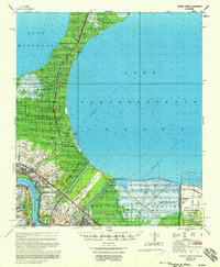 1957 Bonnet Carre1958 Print · USGSCoastal Louisiana at the height of mid-century industrialization reveals a landscape shaped by river management and oil discovery. Trace the footprints of Anchor Plantation, follow the Illinois Central through Ruddock, and see the vast Bonnet Carre Floodway.
End of results
Showing maps 1-14 of 14
Frequently asked questions
- What are the different types of historical maps available for St. Charles Parish?
- What is the oldest map of St. Charles Parish?
- Where can I purchase historical maps of St. Charles Parish for my home or office?
- Where can I download high-res historical maps of St. Charles Parish?
- Are there historical topographic maps available for St. Charles Parish?
- Is there historical aerial imagery available for St. Charles Parish?
- Where are historical maps of St. Charles Parish sourced from?