Old Maps of St. Charles Parish, Louisiana for Hiking & Exploration
Hike through history with 157 historic maps of St. Charles Parish. Explore old trails, ghost towns, and forgotten backroads — perfect for outdoor adventurers and local explorers.
- Rediscover forgotten places: Map out old mining camps, roads, and footpaths that no longer exist on modern maps.
- Layer with modern tools: Combine with LiDAR or satellite views to plan hikes through historical terrain.
- Made for exploration: Popular among hikers, overlanders, and local history lovers.
Use these maps to find adventure and explore the hidden past of St. Charles Parish.
St. Charles Parish, LA maps
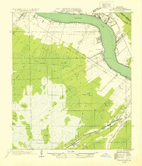
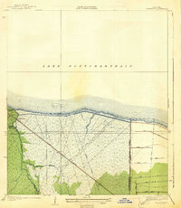
(157)- 1891 Map of Hahnville
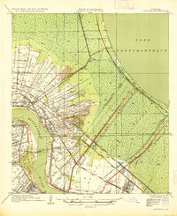
 1891 Hahnville1891 Print · USGSSt. Charles Parish was a hub of river and rail commerce in the late nineteenth century, where new tracks began to bridge the gap between New Orleans and the southern bayous. Researchers can trace historic riverfront tracts at Hahnville and Luling or locate family-named landings such as Pecan Grove and Loquer.5 unique versions available
 - 1891 Map of New Orleans
 1891 New Orleans1891 Print · USGSGreater New Orleans and the surrounding bayous are captured in the late Victorian era as the city's rail and canal networks expanded. Researchers can trace the development of riverfront communities like Gretna and Algiers or locate now-obscure landings such as Jesuit Bend and Amesville.5 unique versions available
 - 1892 Map of Barataria
 1892 Barataria1892 Print · USGSCoastal Jefferson and Plaquemines parishes appear in the late nineteenth century as a sprawling network of marshlands and navigable bayous. Researchers can trace the early rail influence of the N. O. F. J. & G. I. R. R. and locate family landmarks like John the Fool Island and the settlement of Barataria.3 unique versions available
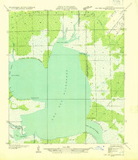
 - 1892 Map of Lac Des Allemands
 1892 Lac Des Allemands1892 Print · USGSCoastal Louisiana at the end of the nineteenth century is defined by its massive marsh basins and early rail corridors. Researchers can trace the original routes of the Southern Pacific Railroad and locate specific sites like the Indian Mound or Raceland Station.4 unique versions available
 - 1892 Map of Mount Airy
 1892 Mount Airy1892 Print · USGSThe lower Mississippi River corridor is captured here in the early 1890s, showcasing the traditional long-lot plantations and burgeoning rail towns. Researchers can trace the early footprints of Edgard and Mt Airy or locate family-named landmarks like Pauline and Johnson along the river's edge.4 unique versions available
 - 1892 Map of Bonnet Carre
 1892 Bonnet Carre1892 Print · USGSThe Louisiana delta in the 1890s reveals a landscape of riverfront settlements and strategic rail lines at the edge of the lake. Trace the path of the Bonnet Carre Crevasse or locate old landings at Frenier, Lucy, and La Branche.3 unique versions available
 - 1892 Map of Cut-Off
 1892 Cut-Off1892 Print · USGSCoastal Louisiana in the 1890s is defined by its reliance on water for transit and trade. Trace the early settlement patterns of Gheens, Harang, and Cut Off along the historic Bayou Lafourche and its connecting canals.4 unique versions available
 - 1932 Map of New Orleans NW
 1932 New Orleans NW1932 Print · USGSJefferson Parish is caught in a moment of rapid transformation in the early thirties as New Orleans expands westward. Researchers can trace the rise of early suburbs like Bonnabel Place, the construction of the Huey P Long Bridge, and the location of the historic Wedell Williams Airport.
 - 1932 Map of New Orleans SW
 1932 New Orleans SW1932 Print · USGSCoastal Louisiana marshes near the Jefferson and St. Charles Parish line are captured in the early thirties as dredging and canals reshaped the delta. Researchers can trace the original courses of Bayou Segnette and Bayou Couba near Woods Place.
 - 1932 Map of Lac Des Allemands SE
 1932 Lac Des Allemands SE1932 Print · USGSLafourche Parish and the surrounding marshlands are captured in the early 1930s as modern transit began following old rail lines. Researchers can trace the legacy of the sugar and transport economy through landmarks like Roux, the Godchaux Canal, and St Lawrence Ch.
 - 1932 Map of Hahnville NW
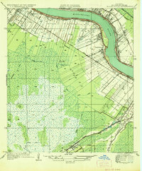
 1932 Hahnville NW1932 Print · USGSSt. Charles Parish in the early thirties shows a river-driven landscape where the Mississippi River bends past Hahnville. Local historians can trace early rail lines like the Texas and Pacific or locate family tracts at Summers and Martins.
 - 1932 Map of Lac Des Allemands NE
 1932 Lac Des Allemands NE1932 Print · USGSCoastal Louisiana at the start of the 1930s is revealed through the intricate bayous and marshlands surrounding Lac Des Allemands. Trace the early drainage patterns and landforms from Carlin Pointe to the Vacherie Canal and Bayou Fortier.
 - 1932 Map of Hahnville SW
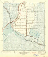
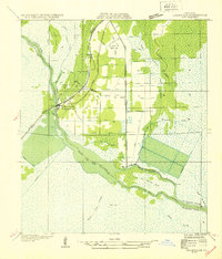 1932 Hahnville SW1932 Print · USGSThe St. Charles Parish wetlands come alive in the early 1930s as a complex network of reclamation canals and bayou transport. Trace the development of Des Allemands and find local landmarks like the St Charles Sch and the Southern Pacific rail line.
 - 1932 Map of Hahnville NE
 1932 Hahnville NE1932 Print · USGSSt. Charles Parish and Jefferson Parish are mapped here in the early thirties as new highways began to parallel the river's path. Researchers can trace the riverfront rail economy and local landmarks like the Kenner Ferry Landing, Lone Star, and the Outfall Canal.
 - 1935 Map of Laplace
 1935 Laplace1935 Print · USGSSt. John the Baptist Parish and St. Charles Parish appear here in the mid-1930s during the early years of the massive Bonnet Carre Spillway project. Genealogists can locate riverfront landmarks like Trinity Plantation and early settlements including Frenier and Lucy.
 - 1935 Map of Luling
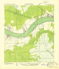
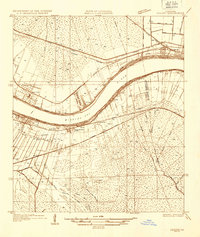 1935 Luling1935 Print · USGSSt. Charles Parish in the mid-1930s shows a landscape of riverfront settlements and vast wetlands managed by an intricate system of canals. Researchers can trace early railroad corridors and local landmarks like Lone Star, Ama, and the historic Davis Crevasse of 1884.
 - 1936 Map of Hahnville
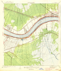
 1936 Hahnville1936 Print · USGSSt. Charles Parish in the mid-1930s reveals a complex landscape of riverfront long-lots, cypress swamps, and new flood control works. Researchers can trace the early footprints of Hahnville and Boutte or locate the Mt Airy Church near the Southern Pacific Railroad.
 - 1936 Map of Bonnet Carre, 1937 Print
 1936 Bonnet Carre1937 Print · USGSThe Louisiana river parishes are shown in transition during the 1930s as massive flood control projects reshape the landscape. Genealogists and researchers can trace the historic Woodland Plantation, locate the Killona Sch, or study the footprints of rail-side towns like Frenier and Laplace.
 - 1938 Map of New Orleans West
 1938 New Orleans West1938 Print · USGSJefferson Parish emerges as a vital transportation hub during the mid-thirties, dominated by the massive river bend and the rise of suburban Metairie. Genealogists and historians can trace the early footprints of Bonnabel Place and Kenner, or locate the historic Deckbar Sch and the U S Marine Hospital.3 unique versions available
 - 1938 Map of La Branche
 1938 La Branche1938 Print · USGSCoastal St. Charles Parish is captured here in the late 1930s, showing a transition from natural marshland to a managed hydraulic landscape. Researchers can trace the Illinois Central railroad through Labranche and locate the engineered Bonnet Carre Floodway.2 unique versions available
 - 1938 Map of Luling
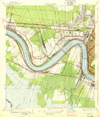
 1938 Luling1938 Print · USGSThe Mississippi River corridor between Luling and Kenner is captured here in the mid-1930s, showing the early integration of the Airline Highway into the landscape. Genealogists can locate old family land tracts and settlements such as Lone Star, St Rose, and Ama, while researchers can trace the site of the historic Davis Crevasse of 1884.3 unique versions available
 - 1939 Map of Cut-Off, 1956 Print
 1939 Cut-Off1956 Print · USGSLafourche Parish marshlands are meticulously detailed here in the late 1930s, showing the settlement string along the bayou levees. Genealogists can locate family landmarks like Bourgeois Sch, Sacred Heart Ch, and the reclaimed lands of Delta Farms.
 - 1940 Map of Allemands
 1940 Allemands1940 Print · USGSCoastal Louisiana marshlands and reclaimed swamps are frozen in time just before the mid-century, centered on the railroad crossing at Des Allemands Sta. Genealogists and historians can trace the grid of the Crawford Canal and locate the St. Charles Sch along the Southern Pacific tracks.2 unique versions available
 - 1941 Map of Cut-Off
 1941 Cut-Off1941 Print · USGSCoastal Lafourche Parish is captured here just before the mid-century, showing the reclaimed wetlands and bayou-side life. Genealogists can trace family settlements at Larose, Valentine, and Gheens, or locate sites like Sacred Heart Ch and Bourgeois Sch.2 unique versions available
 - 1941 Map of Barataria
 1941 Barataria1941 Print · USGSCoastal Jefferson Parish appears at the dawn of the 1940s, where the Mississippi River meets a vast network of bayous and wetlands. Genealogists can trace family roots in Barataria and Jesuit Bend, or locate historic local landmarks like Fisher Sch No 1 and the Lafitte P O.
Showing maps 1-25 of 157
Frequently asked questions
- What are the different types of historical maps available for St. Charles Parish?
- What is the oldest map of St. Charles Parish?
- Where can I purchase historical maps of St. Charles Parish for my home or office?
- Where can I download high-res historical maps of St. Charles Parish?
- Are there historical topographic maps available for St. Charles Parish?
- Is there historical aerial imagery available for St. Charles Parish?
- Where are historical maps of St. Charles Parish sourced from?