1930s Maps of St. James Parish, Louisiana
Explore 3 historic maps of St. James Parish from the 1930s. These maps offer a rare glimpse into what life looked like during the 1930s — showing old roads, neighborhoods, homes, and landmarks that have changed or disappeared over time.
Whether you're researching your family's past, planning a metal detecting trip, or studying how St. James Parish's landscape evolved across the 1930s, these high-resolution maps are a powerful tool for exploring the history of this region.
- Focus on a specific era: All maps on this page are from the 1930s, giving you a focused view of this time period.
- See what’s changed: Compare century-old streets, trails, and buildings to today's modern landscape using overlays and satellite layers.
- Research with precision: Use these maps for genealogy, historical research, land use analysis, or educational projects.
- View, download, or print: Maps are fully viewable online in high resolution, and can be downloaded or printed for your own records.
Start exploring St. James Parish's history through authentic maps from the 1930s. This is your window into the past.
St. James Parish, LA maps
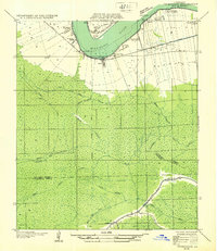
(3)- 1932 Map of Lac Des Allemands NW
 1932 Lac Des Allemands NW1932 Print · USGSSettlement and swamp meet at Vacherie during the early thirties as the region’s sugar and rail economy thrived between the river and the marsh. Family historians can trace local landmarks like Vacherie Sch, the Texas and Pacific rail line, and Coulee du Cimetiere.
 - 1932 Map of Thibodaux NE
 1932 Thibodaux NE1932 Print · USGSSt. James Parish at the height of the plantation era shows the intricate relationship between the river and the swamp. Genealogists can trace family footprints near Jefferson College or local schools like Peties Sch and Chegby Sch.
 - 1939 Map of Donaldsonville, 1953 Print
 1939 Donaldsonville1953 Print · USGSLouisiana's river parishes are captured here in the late 1930s, showing a landscape defined by the winding Mississippi River and its rich agricultural traditions. Genealogists and historians can trace family roots through numerous combined school and church sites like Little Zion Sch Ch & Cem or the sprawling riverside Monroe Plantation.5 unique versions available
End of results
Showing maps 1-3 of 3
Top cities of St. James Parish
Frequently asked questions
- What are the different types of historical maps available for St. James Parish?
- What is the oldest map of St. James Parish?
- Where can I purchase historical maps of St. James Parish for my home or office?
- Where can I download high-res historical maps of St. James Parish?
- Are there historical topographic maps available for St. James Parish?
- Is there historical aerial imagery available for St. James Parish?
- Where are historical maps of St. James Parish sourced from?