Old Maps of St. James Parish, Louisiana for Academic Research
Study the evolution of St. James Parish with 87 high-resolution historic maps. Whether you're teaching, researching, or modeling changes in land use, these maps provide essential visual documentation of urban, environmental, and geographic change.
- Analyze long-term change: Track patterns in development, transportation, and natural features.
- Ideal for environmental or urban studies: Support academic projects with primary historical map data.
- Use in the classroom or lab: Educators and researchers rely on these maps to bring historical context to life.
These maps are a powerful tool for teaching, research, and visualizing how St. James Parish has changed over the decades.
St. James Parish, LA maps
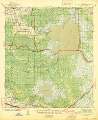
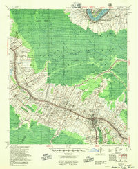
(87)- 1892 Map of Lac Des Allemands
 1892 Lac Des Allemands1892 Print · USGSCoastal Louisiana at the end of the nineteenth century is defined by its massive marsh basins and early rail corridors. Researchers can trace the original routes of the Southern Pacific Railroad and locate specific sites like the Indian Mound or Raceland Station.4 unique versions available
 - 1892 Map of Mount Airy
 1892 Mount Airy1892 Print · USGSThe lower Mississippi River corridor is captured here in the early 1890s, showcasing the traditional long-lot plantations and burgeoning rail towns. Researchers can trace the early footprints of Edgard and Mt Airy or locate family-named landmarks like Pauline and Johnson along the river's edge.4 unique versions available
 - 1892 Map of Donaldsonville
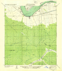
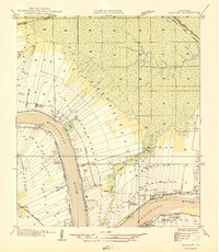
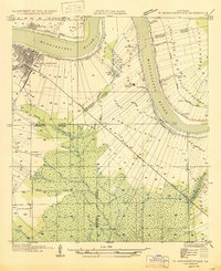
 1892 Donaldsonville1892 Print · USGSLouisiana river life in the early 1890s centered on the great meanders and landings of the river parishes. Genealogists and historians can trace the early footprints of Donaldsonville, locate the Indian Mounds, and see the impact of the Nita Crevasse on the shoreline.12 unique versions available
 - 1892 Map of Thibodaux, 1898 Print
 1892 Thibodaux1898 Print · USGSCajun country at the end of the nineteenth century is defined here by the winding course of Bayou Lafourche and its riverside communities. Genealogists and local historians can trace the early footprints of Thibodeaux and Labadieville alongside rail lines like the Southern Pacific Railroad.3 unique versions available
 - 1927 Map of Thibodaux NW
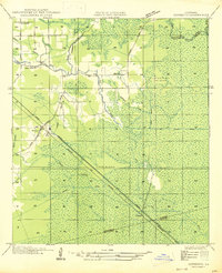
 1927 Thibodaux NW1927 Print · USGSAssumption Parish at the end of the 1920s reveals the intricate ribbon-strip land patterns along the bayous. Genealogists and historians can trace family-named settlements like Albemarle, Aurelia, and Bertie, or locate the St Thomas Sch and Woodlawn Ch.
 - 1932 Map of Lac Des Allemands NW
 1932 Lac Des Allemands NW1932 Print · USGSSettlement and swamp meet at Vacherie during the early thirties as the region’s sugar and rail economy thrived between the river and the marsh. Family historians can trace local landmarks like Vacherie Sch, the Texas and Pacific rail line, and Coulee du Cimetiere.
 - 1932 Map of Thibodaux NE
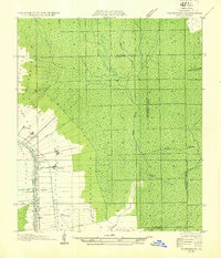
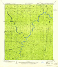
 1932 Thibodaux NE1932 Print · USGSSt. James Parish at the height of the plantation era shows the intricate relationship between the river and the swamp. Genealogists can trace family footprints near Jefferson College or local schools like Peties Sch and Chegby Sch.
 - 1939 Map of Donaldsonville, 1953 Print
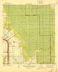
 1939 Donaldsonville1953 Print · USGSLouisiana's river parishes are captured here in the late 1930s, showing a landscape defined by the winding Mississippi River and its rich agricultural traditions. Genealogists and historians can trace family roots through numerous combined school and church sites like Little Zion Sch Ch & Cem or the sprawling riverside Monroe Plantation.5 unique versions available
 - 1940 Map of Lagan
 1940 Lagan1940 Print · USGSSt. James Parish at the cusp of the 1940s retains its deep-rooted plantation landscape along the river's edge. Genealogists and historians can trace family landholdings from Oak Alley Plantation to Bessie K and locate rural landmarks like St Lukes Ch and Chegby Sch.2 unique versions available
 - 1940 Map of Madewood
 1940 Madewood1940 Print · USGSAssumption Parish at the end of the 1930s shows a landscape defined by the sugar economy and the wetlands. Genealogists and historians can trace family locations along Bayou Lafourche through old settlements like Madewood, Albemarle, and Aurelia.2 unique versions available
 - 1941 Map of Lac Des Allemands
 1941 Lac Des Allemands1941 Print · USGSLafourche Parish at the start of the 1940s reveals a water-bound economy of bayous, swamps, and sugar plantations. Genealogists and researchers can trace local church and school sites like St Lawrence Ch and Choctaw Sch alongside historic holdings such as Melodia Plantation.
 - 1944 Map of Lac Des Allemands
 1944 Lac Des Allemands1944 Print · USGSThe swampy interface of St. James and Lafourche parishes comes alive in this mid-century survey of the Mississippi River delta. Genealogists can trace family roots at Golden Star Plantation, Webster Plantation, and community landmarks like St Lawrence Ch.2 unique versions available
 - 1945 Map of New Orleans
 1945 New Orleans1945 Print · USGSCoastal Louisiana and the Mississippi delta are captured here just after the war, showing the region's transition into a modern industrial and transit hub. Genealogists can trace family settlements along Bayou Teche or identify rail stops for the Illinois Central and Texas & Pacific lines.
 - 1946 Map of Convent
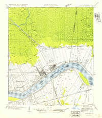
 1946 Convent1946 Print · USGSSt. James Parish life in the 1940s centers on the riverfront plantations and rail-connected settlements along the Mississippi. Researchers can trace family sites near St Josephs Plantation, Oak Alley Plantation, and the community at Convent.
 - 1946 Map of Lutcher
 1946 Lutcher1946 Print · USGSSt. James Parish and the riverfront communities of Lutcher and Gramercy are captured here in the mid-forties, showing the intersection of the Mississippi's bend with the local sugar industry. Researchers can trace historic family lands near Paulina or locate the Longview Sugar Mill and St Joseph Ch.
 - 1946 Map of Petite Amite River
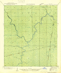 1946 Petite Amite River1946 Print · USGSCoastal Louisiana at the end of the depression era is revealed here as a wild corridor of bayous and shifting parish lines. Trace the path of the Garville Northern (Abandoned) railroad as it cuts through the swamps near Blind River and Black Lake.
 - 1947 Map of Donaldsonville
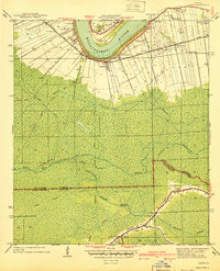
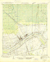
 1947 Donaldsonville1947 Print · USGSThe Mississippi River corridor near Donaldsonville comes to life in this mid-century survey of the river's winding path and industrial shoreline. Researchers can trace the rail lines of the Texas and Pacific, find the Saulsberg Refinery, and locate rural landmarks like the Brulie Maurin Sch.
 - 1947 Map of Sorrento
 1947 Sorrento1947 Print · USGSLouisiana's Ascension Parish is captured here in the mid-1940s as a landscape of vital rail corridors and complex drainage systems. Genealogists and historians can trace old homesteads and routes through Sorrento, Saint Amant, and McElroy along the Airline Highway.
 - 1954 Map of Lutcher
 1954 Lutcher1954 Print · USGSMid-century St. James Parish is defined here by its riverbend sugar economy and the distinct ribbon-lot settlement patterns of the riverbanks. Researchers can trace family history through sites like St Martin Cem, St Joseph Ch, and the Longview Sugar Mill.
 - 1954 Map of Petite Amite River
 1954 Petite Amite River1954 Print · USGSThe swampy confluence of four Louisiana parishes is captured here in the mid-1930s as industrial footprints begin to fade. Researchers can trace the legacy of lost settlements like Garyville and Northern among the winding paths of the Petite Amite River and Bayou Reponds.
 - 1954 Map of Baton Rouge, 1974 Print
 1954 Baton Rouge1974 Print · USGSSoutheast Louisiana in the mid-fifties is captured here during a period of transition for its river and rail economies. Researchers can trace the path of the Mississippi River and find landmarks like the Bonnet Carre Spillway and Bayou Plaquemine.2 unique versions available
 - 1955 Map of Thibodaux
 1955 Thibodaux1955 Print · USGSCoastal Louisiana in the mid-fifties is defined by the winding Bayou Lafourche and the massive Mississippi River. Genealogists and historians can trace numerous family-named sites and plantation tracts, including Laurel Valley Plantation, the New Belmont Ch, Sch & Cem, and the river landing at Moonshine.
 - 1956 Map of Baton Rouge
 1956 Baton Rouge1956 Print · USGSSouth Louisiana at the height of the mid-century oil boom shows a landscape of river oxbows and rising industry. Researchers can trace family roots through river towns like Scotlandville or locate early industrial sites and Oil wells near Lake Maurepas.
 - 1961 Map of Baton Rouge, 1966 Print
 1961 Baton Rouge1966 Print · USGSSoutheastern Louisiana in the early sixties remains a landscape of deep river bends and sprawling coastal lakes. Genealogists and historians can trace the rail-and-river economy through landmarks like Free-Nigger Point, Donaldsonville, and the Illinois Central Railroad.
 - 1962 Map of Baton Rouge
 1962 Baton Rouge1962 Print · USGSSouth Louisiana in the early sixties reveals a landscape of river-bend parishes and emerging interstate corridors. Genealogists and historians can trace family roots through historic river towns like Donaldsonville and Plaquemine, or follow the path of the Illinois Central Railroad through the swamp basins.
Showing maps 1-25 of 87
Top cities of St. James Parish
Frequently asked questions
- What are the different types of historical maps available for St. James Parish?
- What is the oldest map of St. James Parish?
- Where can I purchase historical maps of St. James Parish for my home or office?
- Where can I download high-res historical maps of St. James Parish?
- Are there historical topographic maps available for St. James Parish?
- Is there historical aerial imagery available for St. James Parish?
- Where are historical maps of St. James Parish sourced from?