1940s Maps of Hammond, Louisiana
Explore 2 historic maps of Hammond from the 1940s. These maps offer a rare glimpse into what life looked like during the 1940s — showing old roads, neighborhoods, homes, and landmarks that have changed or disappeared over time.
Whether you're researching your family's past, planning a metal detecting trip, or studying how Hammond's landscape evolved across the 1940s, these high-resolution maps are a powerful tool for exploring the history of this region.
- Focus on a specific era: All maps on this page are from the 1940s, giving you a focused view of this time period.
- See what’s changed: Compare century-old streets, trails, and buildings to today's modern landscape using overlays and satellite layers.
- Research with precision: Use these maps for genealogy, historical research, land use analysis, or educational projects.
- View, download, or print: Maps are fully viewable online in high resolution, and can be downloaded or printed for your own records.
Start exploring Hammond's history through authentic maps from the 1940s. This is your window into the past.
Hammond, LA maps
(2)- 1940 Map of Tickfaw
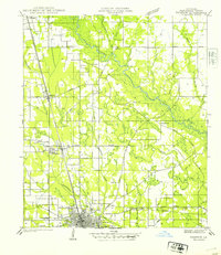 1940 Tickfaw1940 Print · USGSTangipahoa Parish at the start of the 1940s is shown here as a landscape of river-bottom woods and growing railroad towns. Researchers can trace the development of Hammond and SE LA COLLEGE, or locate family landmarks like Red Hill Sch and Colonial Cem.
 - 1949 Map of Albany
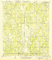 1949 Albany1949 Print · USGSLivingston Parish and Tangipahoa Parish settlements are mapped here just after the war, showing the rural landscape before modern development. Researchers can trace family history through sites like Hoover Cem, Woodhaven, and the Seventh Ward Sch near the Natalbany River.
End of results
Showing maps 1-2 of 2
Top cities near Hammond
- Ponchatoula historical maps
- Maurepas historical maps
- Independence historical maps
- Killian historical maps
- Albany historical maps
- Tickfaw historical maps
See more
Top neighborhoods of Hammond
- Villa West historical maps
- Cypress Cove historical maps
- Westdale historical maps
- Whitmar Acres historical maps
- Woodbridge historical maps
- Lincoln Park historical maps
See more
Frequently asked questions
- What are the different types of historical maps available for Hammond?
- What is the oldest map of Hammond?
- Where can I purchase historical maps of Hammond for my home or office?
- Where can I download high-res historical maps of Hammond?
- Are there historical topographic maps available for Hammond?
- Is there historical aerial imagery available for Hammond?
- Where are historical maps of Hammond sourced from?