1930s Maps of Hammond, Louisiana
Explore 4 historic maps of Hammond from the 1930s. These maps offer a rare glimpse into what life looked like during the 1930s — showing old roads, neighborhoods, homes, and landmarks that have changed or disappeared over time.
Whether you're researching your family's past, planning a metal detecting trip, or studying how Hammond's landscape evolved across the 1930s, these high-resolution maps are a powerful tool for exploring the history of this region.
- Focus on a specific era: All maps on this page are from the 1930s, giving you a focused view of this time period.
- See what’s changed: Compare century-old streets, trails, and buildings to today's modern landscape using overlays and satellite layers.
- Research with precision: Use these maps for genealogy, historical research, land use analysis, or educational projects.
- View, download, or print: Maps are fully viewable online in high resolution, and can be downloaded or printed for your own records.
Start exploring Hammond's history through authentic maps from the 1930s. This is your window into the past.
Hammond, LA maps
(4)- 1934 Map of Springfield
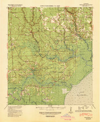
 1934 Springfield1934 Print · USGSLivingston Parish in the early 1930s is a landscape of complex waterways and small riverfront settlements. Genealogists can trace family roots through sites like Davidson Cem, the Hungarian Sch, and many historic landings including Magnolia Ldg.2 unique versions available
 - 1935 Map of Ponchatoula
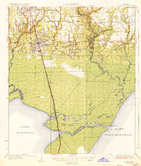 1935 Ponchatoula1935 Print · USGSCoastal Tangipahoa Parish is seen here in the mid-1930s, where the railroad and early highways began to bridge the gap between the piney woods and the great lakes. Researchers can locate family landmarks like Mitchell Cemetery or trace the old routes to the Manchac Akers Post Office and Jones Island.2 unique versions available
 - 1939 Map of Ponchatoula
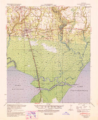 1939 Ponchatoula1939 Print · USGSLouisiana's Florida Parishes are captured here in the late thirties, where the rail lines of the Illinois Central meet the cypress swamps. Researchers can trace family roots at Wetmore Cem or locate the remote Pass Manchac LH and the lumber camps of the Louisiana Cypress Lumber Co.
 - 1939 Map of Springfield
 1939 Springfield1939 Print · USGSCoastal Louisiana at the end of the Depression era reveals a world of river landings and remote parish settlements. Genealogists and researchers can locate family sites like Davidson Cem, local schools such as Hungarian Sch, and numerous river points including Warsaw Log.2 unique versions available
End of results
Showing maps 1-4 of 4
Top cities near Hammond
- Ponchatoula historical maps
- Maurepas historical maps
- Independence historical maps
- Killian historical maps
- Albany historical maps
- Tickfaw historical maps
See more
Top neighborhoods of Hammond
- Villa West historical maps
- Cypress Cove historical maps
- Westdale historical maps
- Whitmar Acres historical maps
- Woodbridge historical maps
- Lincoln Park historical maps
See more
Frequently asked questions
- What are the different types of historical maps available for Hammond?
- What is the oldest map of Hammond?
- Where can I purchase historical maps of Hammond for my home or office?
- Where can I download high-res historical maps of Hammond?
- Are there historical topographic maps available for Hammond?
- Is there historical aerial imagery available for Hammond?
- Where are historical maps of Hammond sourced from?