1930s Maps of Tensas Parish, Louisiana
Explore 5 historic maps of Tensas Parish from the 1930s. These maps offer a rare glimpse into what life looked like during the 1930s — showing old roads, neighborhoods, homes, and landmarks that have changed or disappeared over time.
Whether you're researching your family's past, planning a metal detecting trip, or studying how Tensas Parish's landscape evolved across the 1930s, these high-resolution maps are a powerful tool for exploring the history of this region.
- Focus on a specific era: All maps on this page are from the 1930s, giving you a focused view of this time period.
- See what’s changed: Compare century-old streets, trails, and buildings to today's modern landscape using overlays and satellite layers.
- Research with precision: Use these maps for genealogy, historical research, land use analysis, or educational projects.
- View, download, or print: Maps are fully viewable online in high resolution, and can be downloaded or printed for your own records.
Start exploring Tensas Parish's history through authentic maps from the 1930s. This is your window into the past.
Tensas Parish, LA maps
(5)- 1935 Map of Winnsboro, 1936 Print
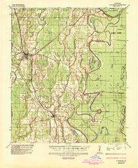 1935 Winnsboro1936 Print · USGSFranklin Parish in the mid-1930s is a landscape of railroad towns and timber landings defined by the winding Macon Bayou. Researchers can trace the Missouri Pacific line through Winnsboro or locate the many historic river crossings like Eureka Ferry and Killens Ferry.2 unique versions available
 - 1935 Map of Shackleford Lake, 1942 Print
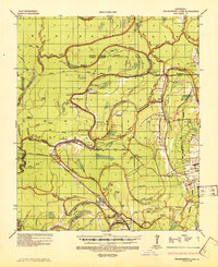 1935 Shackleford Lake1942 Print · USGSThe Tensas River basin in the 1930s shows a complex network of logging railroads and river landings essential to the local timber economy. Genealogists and local historians can trace family sites at Marydale Plantation, Stonewall Ch, and the settlement at Newlight.2 unique versions available
 - 1939 Map of Lorman, 1942 Print
 1939 Lorman1942 Print · USGSThe Mississippi River borderlands thrive with plantation life and early educational institutions during the late nineteen-thirties. You can trace family roots through numerous cemetery-school-church complexes like Richland Sch Ch & Cem and the grounds of Alcorn A & M College.
 - 1939 Map of Natchez, 1943 Print
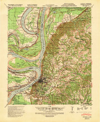 1939 Natchez1943 Print · USGSThe Mississippi River corridor and Natchez area appear in the late thirties as a landscape of river-bottom plantations and bluff-top estates. Genealogists can locate family landmarks like Hole in the Wall Plantation, Briars Plantation, and Gilfield Ch & Sch.3 unique versions available
 - 1939 Map of Locust Ridge, 1965 Print
 1939 Locust Ridge1965 Print · USGSThe Mississippi Delta in the late 1930s reveals a land of sprawling plantations and bayou settlements along the Louisiana border. Genealogists can trace family landmarks like the Mayflower Cem, Maryland Plantation Cem, and New St Mark Ch among the meanders of the river.
End of results
Showing maps 1-5 of 5
Top cities of Tensas Parish
Frequently asked questions
- What are the different types of historical maps available for Tensas Parish?
- What is the oldest map of Tensas Parish?
- Where can I purchase historical maps of Tensas Parish for my home or office?
- Where can I download high-res historical maps of Tensas Parish?
- Are there historical topographic maps available for Tensas Parish?
- Is there historical aerial imagery available for Tensas Parish?
- Where are historical maps of Tensas Parish sourced from?