Old Maps of Cocodrie, Louisiana for Genealogy
Trace your family roots with 13 historic maps of Cocodrie. These high-res maps reveal old neighborhoods, homesites, landmarks, and streets — helping you uncover where your ancestors lived and how the area evolved over time.
- Explore historic neighborhoods: Identify where your relatives may have lived in the 1800s or 1900s.
- Compare maps over time: Trace the changes in streets, buildings, and landmarks for multi-generational research.
- Perfect for genealogy & ancestry research: Used by family historians and researchers to map out lineage and migration.
These maps are an incredible resource for exploring your personal connection to Cocodrie's past.
Cocodrie, LA maps
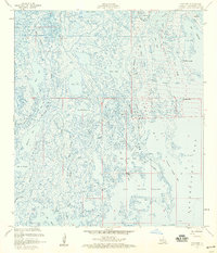
(13)- 1935 Map of Cocodrie
 1935 Cocodrie1935 Print · USGSCoastal Louisiana marshes in the mid-1930s present a complex world of tidewater channels and expansive bays. Researchers can trace the original shorelines of Bay Sainte Elaine, Cooke Pt, and the winding course of Little Cocodrie Bayou.
 - 1945 Map of Cocodrie
 1945 Cocodrie1945 Print · USGSThe wetlands of southern Louisiana are shown here in the mid-forties, just as aerial photography began to redefine coastal mapping. Researchers can trace the complex tidal networks of Bay Cocodrie, Bay Sainte Elaine, and Tambour Bay.
 - 1945 Map of New Orleans
 1945 New Orleans1945 Print · USGSCoastal Louisiana and the Mississippi delta are captured here just after the war, showing the region's transition into a modern industrial and transit hub. Genealogists can trace family settlements along Bayou Teche or identify rail stops for the Illinois Central and Texas & Pacific lines.
 - 1957 Map of Cocodrie, 1959 Print
 1957 Cocodrie1959 Print · USGSCoastal Louisiana in the mid-fifties reveals an intricate network of marshes and industrial development. Trace the early petroleum footprint across Bay Sainte Elaine through the GAS FIELD, Coon Road, and family-named waterways like Austrian Bayou.3 unique versions available
 - 1963 Map of New Orleans
 1963 New Orleans1963 Print · USGSCoastal Louisiana in the mid-twentieth century reveals a complex world of bayou settlements, expanding oil fields, and vital rail networks. Genealogists and historians can trace family roots through river towns like Thibodaux or follow the Southern Pacific line through Franklin and Patterson.4 unique versions available
 - 1966 Map of New Orleans
 1966 New Orleans1966 Print · USGSCoastal Louisiana in the mid-1960s reveals a transition from traditional bayou life to an intensive offshore oil and gas economy. Researchers can trace the rail lines of the Southern Pacific RR through Morgan City or locate the Eugene Island Lighthouse among the delta's shifting marshes.
 - 1983 Map of Terrebonne Bay
 1983 Terrebonne Bay1983 Print · USGSThe Louisiana coast in the early 1980s reveals a labyrinth of bayous and barrier islands before decades of significant shoreline change. Researchers can trace the development of the energy industry and coastal settlements like Galliano and Montegut alongside the Isles Dernieres.
 - 1994 Map of Cocodrie
 1994 Cocodrie1994 Print · USGSThe Louisiana coast south of Houma is shown in the mid-nineties as a hub of energy production and coastal marsh. Researchers can trace offshore platforms across the Sainte Elaine Oil Field and Bay Coon Road.
 - 2012 Map of Cocodrie, 2012 Print
 2012 Cocodrie2012 Print · USGSCovers Cocodrie, including Terrebonne Parish, United States, and other nearby areas
 - 2015 Map of Cocodrie, 2015 Print
 2015 Cocodrie2015 Print · USGSCovers Cocodrie, including Terrebonne Parish, United States, and other nearby areas
 - 2018 Map of Cocodrie, 2018 Print
 2018 Cocodrie2018 Print · USGSCovers Cocodrie, including Terrebonne Parish, United States, and other nearby areas
 - 2020 Map of Cocodrie, 2020 Print
 2020 Cocodrie2020 Print · USGSCovers Cocodrie, including Terrebonne Parish, United States, and other nearby areas
 - 2024 Map of Cocodrie, 2024 Print
 2024 Cocodrie2024 Print · USGSThe coastal reaches of Terrebonne Parish are captured here in the early twenty-first century, centered on the fishing hub of Cocodrie. Researchers can trace the vital maritime corridors of the Houma Navigation Canal and the winding course of Bayou Petit Caillou.
End of results
Showing maps 1-13 of 13
Top cities near Cocodrie
Frequently asked questions
- What are the different types of historical maps available for Cocodrie?
- What is the oldest map of Cocodrie?
- Where can I purchase historical maps of Cocodrie for my home or office?
- Where can I download high-res historical maps of Cocodrie?
- Are there historical topographic maps available for Cocodrie?
- Is there historical aerial imagery available for Cocodrie?
- Where are historical maps of Cocodrie sourced from?