Old Maps of Abbeville, Louisiana for Academic Research
Study the evolution of Abbeville with 24 high-resolution historic maps. Whether you're teaching, researching, or modeling changes in land use, these maps provide essential visual documentation of urban, environmental, and geographic change.
- Analyze long-term change: Track patterns in development, transportation, and natural features.
- Ideal for environmental or urban studies: Support academic projects with primary historical map data.
- Use in the classroom or lab: Educators and researchers rely on these maps to bring historical context to life.
These maps are a powerful tool for teaching, research, and visualizing how Abbeville has changed over the decades.
Abbeville, LA maps
(24)- 1932 Map of Abbeville NE
 1932 Abbeville NE1932 Print · USGSVermilion Parish comes into focus during the early 1930s, showing a landscape defined by the Southern Pacific rail line and the winding Vermilion Bayou. Genealogists and historians can trace family roots through markers like Landry Cem, Rose Hill Ch, and the rural community of Erath.
 - 1932 Map of Abbeville NW
 1932 Abbeville NW1932 Print · USGSVermilion Parish at the start of the 1930s reveals a landscape of winding bayous and a burgeoning canal network. Genealogists and historians can trace the foundations of local life at Briggs Chapel, the Moutons Cove Sch, and the river crossing at Bancker Ferry.
 - 1954 Map of Port Arthur
 1954 Port Arthur1954 Print · USGSThe Texas and Louisiana coastlines meet here in the mid-fifties, showing the industrial rise of Port Arthur alongside vast wildlife preserves. Researchers can trace remote coastal settlements and infrastructure like Pecan Island, the Sabine Pass Lighthouse, and the North Island School.
 - 1954 Map of Abbeville, 1956 Print
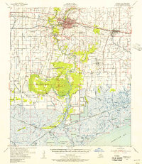 1954 Abbeville1956 Print · USGSVermilion Parish in the mid-fifties is captured here as a landscape of river-fed commerce and coastal marsh. Genealogists can trace family heritage through sites like Live Oak Plantation, Briggs Chapel, and the Mouton Cove Sch.3 unique versions available
 - 1956 Map of Port Arthur, 1965 Print
 1956 Port Arthur1965 Print · USGSThe Texas and Louisiana coastlines meet here in the mid-fifties, showing a landscape of sprawling marshes and growing refinery towns. Genealogists and historians can trace ridge settlements like Grand Cheniere or find the Sabine Pass Lighthouse and Pecan Island.3 unique versions available
 - 1958 Map of Port Arthur
 1958 Port Arthur1958 Print · USGSThe Texas and Louisiana coastlines meet in the late fifties at the busy industrial port of Port Arthur. Historians and genealogists can trace the early rail networks of the Southern Pacific and locate coastal settlements like Cameron, Pecan Island, and Abbeville.
 - 1959 Map of Port Arthur
 1959 Port Arthur1959 Print · USGSThe Texas and Louisiana coastlines meet in this late-fifties study of a landscape defined by industry and wildlife preserves. Trace the Intracoastal Waterway past Pecan Island and Abbeville, or locate the shipping channels at Sabine Pass.
 - 1973 Map of Port Arthur, 1974 Print
 1973 Port Arthur1974 Print · USGSThe Texas-Louisiana borderlands in the early seventies reveal an intricate landscape of coastal marshes and heavy industry. Trace the growth of Port Arthur, the extent of the oil and gas fields, and old ridge settlements like Pecan Island.
 - 1975 Map of Abbeville East, 1978 Print
 1975 Abbeville East1978 Print · USGSVermilion Parish in the mid-seventies reveals a unique intersection of Cajun agricultural life and the booming energy industry. Researchers can trace the development of Erath and Abbeville while identifying local landmarks like Rose Hill Ch, Crawfish Farms, and numerous family cemeteries.
 - 1975 Map of Abbeville West, 1978 Print
 1975 Abbeville West1978 Print · USGSLouisiana's Vermilion Parish comes alive in the mid-seventies, showing the city of Abbeville as it borders the winding Vermilion River. Genealogists can trace family roots through landmarks like Briggs Cem, Hebert Cem, and the Seventh Ward Sch.
 - 1975 Map of Abbeville, 1978 Print
 1975 Abbeville1978 Print · USGSThe Vermilion Parish coast in the mid-seventies shows a landscape defined by the Vermilion River and the industrial activity of the Intracoastal Waterway. Researchers can locate historic local landmarks including Live Oak Plantation, St Paul Cem, and the settlement at Intracoastal City.
 - 1983 Map of White Lake
 1983 White Lake1983 Print · USGSCoastal Louisiana at the start of the 1980s reveals a world of remote chenier settlements and vast marshlands. Genealogists and historians can trace family locations along Grand Chenier Ridge or explore the hubs of Abbeville and Intracoastal City.2 unique versions available
 - 1994 Map of Abbeville East, 1998 Print
 1994 Abbeville East1998 Print · USGSVermilion Parish in the mid-1990s shows a landscape defined by the sugar and energy industries. Researchers can trace family history through sites like Trahan Cem or explore the infrastructure of the Erath Oil and Gas Field and Henry.
 - 1994 Map of Abbeville West, 1998 Print
 1994 Abbeville West1998 Print · USGSThe Vermilion Parish landscape comes into focus during the mid-nineties as a sophisticated network of levees and aquaculture. Genealogists and local historians can trace family-named sites like Hebert Cem or explore the development around Perry and Rose Hill.
 - 2012 Map of Abbeville East, 2012 Print
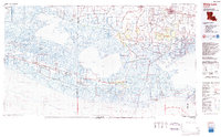
 2012 Abbeville East2012 Print · USGSCovers Abbeville, including Erath, Camille, and other nearby areas
 - 2012 Map of Abbeville West, 2012 Print
 2012 Abbeville West2012 Print · USGSCovers Abbeville, including Rose Hill, Mouton Cove, and other nearby areas
 - 2015 Map of Abbeville East, 2015 Print
 2015 Abbeville East2015 Print · USGSCovers Abbeville, including Erath, Camille, and other nearby areas
 - 2015 Map of Abbeville West, 2015 Print
 2015 Abbeville West2015 Print · USGSCovers Abbeville, including Rose Hill, Mouton Cove, and other nearby areas
 - 2018 Map of Abbeville West, 2018 Print
 2018 Abbeville West2018 Print · USGSCovers Abbeville, including Rose Hill, Mouton Cove, and other nearby areas
 - 2018 Map of Abbeville East, 2018 Print
 2018 Abbeville East2018 Print · USGSCovers Abbeville, including Erath, Camille, and other nearby areas
 - 2020 Map of Abbeville West, 2020 Print
 2020 Abbeville West2020 Print · USGSCovers Abbeville, including Rose Hill, Mouton Cove, and other nearby areas
 - 2020 Map of Abbeville East, 2020 Print
 2020 Abbeville East2020 Print · USGSCovers Abbeville, including Erath, Camille, and other nearby areas
 - 2024 Map of Abbeville West, 2024 Print
 2024 Abbeville West2024 Print · USGSCoastal Vermilion Parish in the early 2020s reveals a unique landscape where the historic parish seat of Abbeville transitions into a complex network of canals and coulees. Researchers can trace family history at sites like Saint Mary Magdalen Cem or locate rural landmarks such as Ken Guidry Number 1 Airport.
 - 2024 Map of Abbeville East, 2024 Print
 2024 Abbeville East2024 Print · USGSVermilion Parish comes into focus at the start of the 2020s, showing the reach of Abbeville toward the communities of Erath and Delcambre. Family historians can locate numerous burial sites like Trahan Cem and Landry Cem alongside the winding Vermilion River.
End of results
Showing maps 1-24 of 24
Top cities near Abbeville
- Lafayette historical maps
- Crowley historical maps
- Scott historical maps
- Youngsville historical maps
- Kaplan historical maps
- Erath historical maps
See more
Top neighborhoods of Abbeville
- Abbeville Commercial Historic District historical maps
- Abbeville Residential Historic District historical maps
Frequently asked questions
- What are the different types of historical maps available for Abbeville?
- What is the oldest map of Abbeville?
- Where can I purchase historical maps of Abbeville for my home or office?
- Where can I download high-res historical maps of Abbeville?
- Are there historical topographic maps available for Abbeville?
- Is there historical aerial imagery available for Abbeville?
- Where are historical maps of Abbeville sourced from?