1940s Maps of Winn Parish, Louisiana
Explore 8 historic maps of Winn Parish from the 1940s. These maps offer a rare glimpse into what life looked like during the 1940s — showing old roads, neighborhoods, homes, and landmarks that have changed or disappeared over time.
Whether you're researching your family's past, planning a metal detecting trip, or studying how Winn Parish's landscape evolved across the 1940s, these high-resolution maps are a powerful tool for exploring the history of this region.
- Focus on a specific era: All maps on this page are from the 1940s, giving you a focused view of this time period.
- See what’s changed: Compare century-old streets, trails, and buildings to today's modern landscape using overlays and satellite layers.
- Research with precision: Use these maps for genealogy, historical research, land use analysis, or educational projects.
- View, download, or print: Maps are fully viewable online in high resolution, and can be downloaded or printed for your own records.
Start exploring Winn Parish's history through authentic maps from the 1940s. This is your window into the past.
Winn Parish, LA maps
(8)- 1942 Map of Montgomery, 1956 Print
 1942 Montgomery1956 Print · USGSCentral Louisiana parish borders meet along the shifting bends of the Red River during the early 1940s. Genealogists and historians can trace the dense settlement of the Cane River valley through landmarks like Cloutierville, St Augustines Ch, and Melrose.
 - 1945 Map of Montgomery
 1945 Montgomery1945 Print · USGSCentral Louisiana life during the 1940s centered on the Red River and the expanding timber industry. Researchers can trace historic family landmarks through schools like Cockfield Sch, churches such as Mt Zion Ch, and the numerous bayous of the Kisatchie National Forest.
 - 1947 Map of Goldonna
 1947 Goldonna1947 Print · USGSNorth Louisiana's timber and rail country is captured here just after the war, showing the rural communities of Natchitoches and Bienville Parishes. Researchers can locate local landmarks like Blooms Mill, trace the Louisiana and Arkansas Railroad, or find old school sites like Readhimer Sch.
 - 1949 Map of Calvin SE
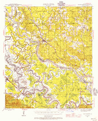
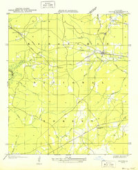
 1949 Calvin SE1949 Print · USGSWinn Parish enters the post-war era as a timber and rail corridor deeply integrated with the Kisatchie National Forest. Genealogists can trace rural community life through the Kimbrell Cem, Couley Ch, and the long-lost Emden Sch.
 - 1949 Map of Calvin NE
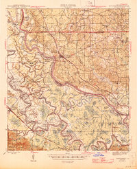
 1949 Calvin NE1949 Print · USGSWinn Parish at the end of the 1940s reveals a landscape of dense national forest and dispersed rural life. Researchers can locate family landmarks such as Sanders Ch, the CCC Camp, and the Gum Springs Lookout along the winding parish creeks.
 - 1949 Map of Calvin NW
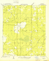
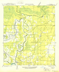
 1949 Calvin NW1949 Print · USGSThe rural marshlands of Natchitoches Parish are documented here in the late 1940s, showing the eastern edge of the Kisatchie National Forest. Genealogists and historians can trace local landmarks like Evergreen Ch, Clear Lake Sch, and the winding Saline Bayou.
 - 1949 Map of Calvin SW
 1949 Calvin SW1949 Print · USGSThe parish line of Natchitoches and Winn follows the twisting course of Saline Bayou during the late Forties. Researchers can trace the rural layout of churches and schools like Christian Harmony Ch, Pace Sch, and St Maurice along the river.
 - 1949 Map of Jonesboro, 1958 Print
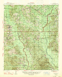
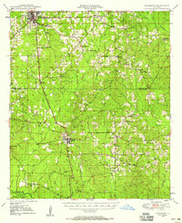 1949 Jonesboro1958 Print · USGSJackson and Winn Parish come alive in the late 1940s, showing a landscape of timberlands and rail-centered settlements. Researchers can trace rural life through landmarks like Gaars Mill Sch, Zion Hill Ch, and the Winona Lookout Tower.3 unique versions available
End of results
Showing maps 1-8 of 8
Top cities of Winn Parish
- Winnfield historical maps
- Dodson historical maps
- Calvin historical maps
- Atlanta historical maps
- Sikes historical maps
Frequently asked questions
- What are the different types of historical maps available for Winn Parish?
- What is the oldest map of Winn Parish?
- Where can I purchase historical maps of Winn Parish for my home or office?
- Where can I download high-res historical maps of Winn Parish?
- Are there historical topographic maps available for Winn Parish?
- Is there historical aerial imagery available for Winn Parish?
- Where are historical maps of Winn Parish sourced from?