1980s Maps of T8 R3 WELS, Maine
Explore 5 historic maps of T8 R3 WELS from the 1980s. These maps offer a rare glimpse into what life looked like during the 1980s — showing old roads, neighborhoods, homes, and landmarks that have changed or disappeared over time.
Whether you're researching your family's past, planning a metal detecting trip, or studying how T8 R3 WELS's landscape evolved across the 1980s, these high-resolution maps are a powerful tool for exploring the history of this region.
- Focus on a specific era: All maps on this page are from the 1980s, giving you a focused view of this time period.
- See what’s changed: Compare century-old streets, trails, and buildings to today's modern landscape using overlays and satellite layers.
- Research with precision: Use these maps for genealogy, historical research, land use analysis, or educational projects.
- View, download, or print: Maps are fully viewable online in high resolution, and can be downloaded or printed for your own records.
Start exploring T8 R3 WELS's history through authentic maps from the 1980s. This is your window into the past.
T8 R3 WELS, ME maps
(5)- 1985 Map of Oakfield
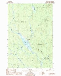
 1985 Oakfield1985 Print · USGSAroostook County in the 1980s displays a balance between the timber-and-rail industry and the protected wilderness of the North Woods. Genealogists and local historians can trace family-named hubs like Smyrna Mills, Island Falls, and Knowles Corner along the Bangor and Aroostook railroad line.
 - 1986 Map of St. Croix Lake
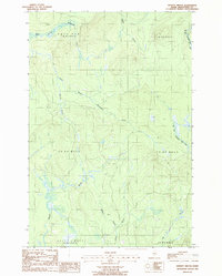
 1986 St. Croix Lake1986 Print · USGSIn the remote woods of Aroostook County during the mid-1980s, these northern townships remained defined by their water systems and isolated settlements. Researchers can trace the early layout of Howe Brook, the railroad siding at Weeksboro, and old timber landmarks like Roll Dam Brook.
 - 1986 Map of Spinney Brook, 1987 Print
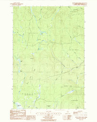
 1986 Spinney Brook1987 Print · USGSAroostook County's deep woods are captured here in the mid-1980s, showing a landscape defined by timber tracts and a complex network of waterways. Genealogists and historians can trace the paths of Spinney Brook and Tie Camp Brook through townships like Squapan.
 - 1986 Map of North Brook Ridge, 1987 Print
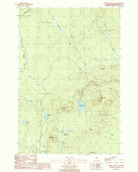
 1986 North Brook Ridge1987 Print · USGSAroostook County's remote timberlands are captured here in the mid-1980s, showing a landscape defined by logging roads and glacial hydrology. Researchers can trace the path of Carlisle Road past The Pinnacle or locate the wetlands of Thousand Acre Swamp.
 - 1986 Map of Number Nine Lake, 1987 Print
 1986 Number Nine Lake1987 Print · USGSAroostook County was a landscape of timber and sporting camps in the 1980s, before modern development further altered the north woods. Map collectors and hikers can trace the rugged topography of Number Nine Mtn and find the locations of remote outposts like Mahan Camp and Finnemore Camp.
End of results
Showing maps 1-5 of 5
Top cities near T8 R3 WELS
- Houlton historical maps
- Mars Hill historical maps
- Ashland historical maps
- Littleton historical maps
- Monticello historical maps
- Blaine historical maps
See more
Frequently asked questions
- What are the different types of historical maps available for T8 R3 WELS?
- What is the oldest map of T8 R3 WELS?
- Where can I purchase historical maps of T8 R3 WELS for my home or office?
- Where can I download high-res historical maps of T8 R3 WELS?
- Are there historical topographic maps available for T8 R3 WELS?
- Is there historical aerial imagery available for T8 R3 WELS?
- Where are historical maps of T8 R3 WELS sourced from?