1900s (20th Century) Maps of Cumberland County, Maine
Explore 117 historic maps of Cumberland County from the 1900s (20th Century). These maps offer a rare glimpse into what life looked like during the 1900s — showing old roads, neighborhoods, homes, and landmarks that have changed or disappeared over time.
Whether you're researching your family's past, planning a metal detecting trip, or studying how Cumberland County's landscape evolved across the 1900s, these high-resolution maps are a powerful tool for exploring the history of this region.
- Focus on a specific era: All maps on this page are from the 1900s, giving you a focused view of this time period.
- See what’s changed: Compare century-old streets, trails, and buildings to today's modern landscape using overlays and satellite layers.
- Research with precision: Use these maps for genealogy, historical research, land use analysis, or educational projects.
- View, download, or print: Maps are fully viewable online in high resolution, and can be downloaded or printed for your own records.
Start exploring Cumberland County's history through authentic maps from the 1900s. This is your window into the past.
Cumberland County, ME maps
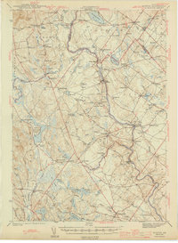
(117)- 1908 Map of Poland
 1908 Poland1908 Print · USGSAndroscoggin County was a thriving hub of rail transport and lakeside resorts in the early nineteen-hundreds. Here you can trace the historic Grand Trunk Railway corridor through Mechanic Falls and locate the famous Poland Spring resort grounds.5 unique versions available
 - 1909 Map of Fryeburg, 1960 Print
 1909 Fryeburg1960 Print · USGSOxford County and the borderlands of Maine and New Hampshire were defined by the shifting waters of the Saco and the Kezar at the century's turn. Genealogists can trace family homesteads near the Battle Monument or locate rural schoolhouses like Foxboro School and Menotomy School.3 unique versions available
 - 1910 Map of Kezar Falls
 1910 Kezar Falls1910 Print · USGSMaine and New Hampshire borderlands are captured here at the height of the railroad era, as the Maine Central linked river towns. Genealogists can trace family footprints through sites like the Parsonsfield Seminary, Merrill Corner, and the Haley School.5 unique versions available
 - 1911 Map of Fryeburg
 1911 Fryeburg1911 Print · USGSOxford County at the start of the century shows a landscape of lake-fed valleys and the bustling rail corridor of the Maine Central RR. Genealogists and historians can trace old school districts like Foxboro School, local landmarks like the Battle Monument, and early settlements at Slab City and Lynchville.6 unique versions available
 - 1911 Map of Kezar Falls
 1911 Kezar Falls1911 Print · USGSThe Saco River valley at the turn of the century shows a landscape defined by riverside industry and mountain schools. Genealogists and historians can trace rail depots like Bridgton Junction and early landmarks such as Parsonsfield Seminary and Rankins Mill.5 unique versions available
 - 1914 Map of Portland
 1914 Portland1914 Print · USGSCoastal Maine at the start of the twentieth century shows a landscape tied together by industrial rivers and an expanding network of electric railroads. Genealogists can locate family names at Hillside Cemetery or trace old rural schoolhouses like the Babb School and Beech Ridge School.
 - 1914 Map of Casco Bay
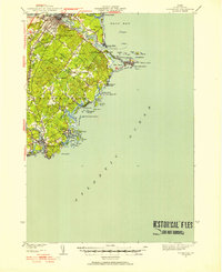
 1914 Casco Bay1914 Print · USGSCumberland County's coastline and islands are shown in 1914, featuring a landscape of active coastal defenses and bustling maritime travel. Researchers can locate prominent landmarks such as Fort Mc Kinley, the Portland Head Light, and various steamer stops like Eastern Landing.
 - 1916 Map of Portland
 1916 Portland1916 Print · USGSGreater Portland and the Cumberland County coast are documented here during the height of the trolley and rail era. Researchers can trace ancestral property near the Evergreen Cemetery, early industries at Cumberland Mills, and vanished local sites like the State Reform School.7 unique versions available
 - 1916 Map of Casco Bay
 1916 Casco Bay1916 Print · USGSCumberland County’s shoreline was a landscape of strategic military forts and busy steamboat landings in the years before the Great War. Genealogists and historians can trace coastal heritage through landmarks like Fort Williams, Pine Grove School, and the scattered piers of Falmouth Foreside.8 unique versions available
 - 1916 Map of Portland And Vicinity
 1916 Portland And Vicinity1916 Print · USGSCoastal Maine at the start of the Great War reveals a landscape of heavy coastal fortifications and bustling rail terminals. Trace old neighborhood boundaries and family landmarks like Milliken Mills, Hillside Cemetery, and the Portland Head lighthouse.
 - 1918 Map of Portland And Vicinity, 1926 Print
 1918 Portland And Vicinity1926 Print · USGSCoastal Maine at the height of the Great War reveals a landscape of harbor forts, railroad junctions, and seaside settlements. Genealogists and historians can trace family roots through labels for Evergreen Cemetery, Spurwink Church, and dozens of rural schoolhouses like Babb School.
 - 1919 Map of Small Point
 1919 Small Point1919 Print · USGSThe Maine coastline at the mouth of the Kennebec is captured in this era of transition, detailing the rocky islands and harbors of the outer Casco Bay. Genealogists and maritime historians can trace coastal settlements at Popham Beach and Bailey Island, or locate landmarks like Seguin Light and Small Pt Harbor.
 - 1920 Map of Bath
 1920 Bath1920 Print · USGSCoastal Maine at the height of the rail era is captured here, showing the intricate tidal waters surrounding Bath and Brunswick. Genealogists and local historians can trace family locations near Nequasset Falls, Cundy Harbor, and the Quaker church.2 unique versions available
 - 1940 Map of Poland, 1942 Print
 1940 Poland1942 Print · USGSMaine's river valleys and rail junctions come to life in the 1940s as the region's industrial and rural networks are captured in detail. Genealogists can trace family landmarks like Hebron Sta P O, the Sanitarium, and the busy hub at Mechanic Falls.
 - 1941 Map of Casco Bay
 1941 Casco Bay1941 Print · USGSCasco Bay and its vital harbor defenses are captured here just as the nation prepared for war. Military historians and genealogists can locate Fort McKinley and Fort Williams alongside local landmarks like Pine Grove Sch.
 - 1941 Map of Portland
 1941 Portland1941 Print · USGSCoastal Maine at the start of the 1940s reveals a bustling corridor of river mills and seaside settlements. Genealogists and historians can trace family roots through numerous local schools and landmarks like Cumberland Mills, Spurwink Ch, and Prouts Neck.
 - 1941 Map of Fryeburg
 1941 Fryeburg1941 Print · USGSOxford County and the Maine-New Hampshire borderlands are captured here just before the war, showcasing a landscape of isolated hills and interconnected lakes. Genealogists can locate family-named landmarks like Mc Daniels Hill and numerous rural schools including Plummer Sch and Black Mountain Sch.
 - 1941 Map of Biddeford, 1952 Print
 1941 Biddeford1952 Print · USGSThe York County coastline during the early years of the war reveals a landscape of tidal harbors and rural school districts. Genealogists and historians can locate family plots at Laurel Hill Cem or trace old routes like Guinea Road past the Nott Sch.2 unique versions available
 - 1941 Map of Freeport, 1957 Print
 1941 Freeport1957 Print · USGSCumberland County at the dawn of the 1940s shows a landscape defined by the Androscoggin River and the rugged shoreline of Casco Bay. Local researchers can trace family roots through numerous burial grounds like Elmlawn Cem or locate forgotten schoolhouses like Hacker Sch and Hicks Sch.
 - 1942 Map of Poland
 1942 Poland1942 Print · USGSSouth-central Maine is captured here in the early 1940s, showing a landscape of rail-linked mill towns and hilltop farms. Genealogists can trace family names at Hebron Sta P O, Danville Corner, and the Empire Grove Campground.
 - 1942 Map of Gray, 1956 Print
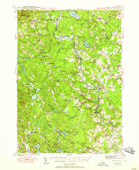
 1942 Gray1956 Print · USGSCumberland County’s interior landscape comes into focus during the early 1940s, revealing a network of rail-side stations and crossroads hamlets. Genealogists and historians can trace family locations near Suckerville, Purinton Cem, and the Friends Ch.
 - 1942 Map of Buxton, 1958 Print
 1942 Buxton1958 Print · USGSIn the early 1940s, the river valleys of southern Maine were defined by a tight-knit network of mill towns and rail corridors. Trace family roots and local industry through features like Salmon Falls, Shaw Mills, and the Chadbourne Cem.3 unique versions available
 - 1942 Map of Sebago Lake, 1959 Print
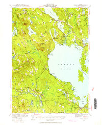 1942 Sebago Lake1959 Print · USGSCumberland County’s lakes and ridges were well-established as a summer destination in the early 1940s, centered around the expanse of Sebago Lake. Researchers can trace old rail routes at East Baldwin Mattocks Sta, find the historic Potter Academy, or locate family sites near South Naples.3 unique versions available
 - 1943 Map of Sebago Lake
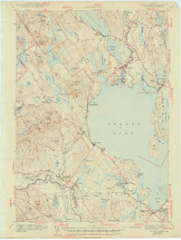 1943 Sebago Lake1943 Print · USGSMaine's lake country thrived during the early 1940s as a hub of rail commerce and early recreation. You can trace the Maine Central Railroad through Steep Falls or find local landmarks like Potter Academy and Songo Lock.3 unique versions available
 - 1944 Map of Buxton
 1944 Buxton1944 Print · USGSThe Saco River valley during the mid-forties reveals a landscape of mill towns and interconnected rural hamlets. Genealogists and local historians can trace the foundations of Bar Mills, locate the Chadbourne Cem, or follow the path of the Boston and Maine railroad.3 unique versions available
Showing maps 1-25 of 117
Top cities of Cumberland County
- Portland historical maps
- South Portland historical maps
- Scarborough historical maps
- Brunswick historical maps
- Westbrook historical maps
- Windham historical maps
See more
Frequently asked questions
- What are the different types of historical maps available for Cumberland County?
- What is the oldest map of Cumberland County?
- Where can I purchase historical maps of Cumberland County for my home or office?
- Where can I download high-res historical maps of Cumberland County?
- Are there historical topographic maps available for Cumberland County?
- Is there historical aerial imagery available for Cumberland County?
- Where are historical maps of Cumberland County sourced from?