1960s Maps of Cumberland County, Maine
Explore 9 historic maps of Cumberland County from the 1960s. These maps offer a rare glimpse into what life looked like during the 1960s — showing old roads, neighborhoods, homes, and landmarks that have changed or disappeared over time.
Whether you're researching your family's past, planning a metal detecting trip, or studying how Cumberland County's landscape evolved across the 1960s, these high-resolution maps are a powerful tool for exploring the history of this region.
- Focus on a specific era: All maps on this page are from the 1960s, giving you a focused view of this time period.
- See what’s changed: Compare century-old streets, trails, and buildings to today's modern landscape using overlays and satellite layers.
- Research with precision: Use these maps for genealogy, historical research, land use analysis, or educational projects.
- View, download, or print: Maps are fully viewable online in high resolution, and can be downloaded or printed for your own records.
Start exploring Cumberland County's history through authentic maps from the 1960s. This is your window into the past.
Cumberland County, ME maps
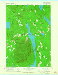
(9)- 1961 Map of Lewiston
 1961 Lewiston1961 Print · USGSWestern Maine and the White Mountains appear here during the early sixties, showing the industrial river towns and vast timberlands before the modern interstate era. Genealogists and historians can trace the Grand Trunk RR through Berlin or locate landmarks like Old Speck Mountain and Elephant Mountain.
 - 1962 Map of Lewiston
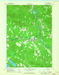
 1962 Lewiston1962 Print · USGSThe industrial river valleys and high peaks of Maine and New Hampshire define the region in the early sixties. Trace the rail-and-river network from Lewiston to the White Mountains, passing through mill towns like Berlin and Rumford.
 - 1963 Map of Portland
 1963 Portland1963 Print · USGSCoastal Maine and New Hampshire thrived as maritime and industrial hubs during the mid-sixties, linked by a dense network of rail and river. Researchers can trace historic transit corridors like the Maine Central RR and locate key sites such as the Portsmouth Naval Shipyard or Pease Air Force Base.3 unique versions available
 - 1963 Map of Bath
 1963 Bath1963 Print · USGSThe Maine Midcoast in the early sixties remains a world of tidal rivers and jagged peninsulas tied to the sea. Genealogy and local history researchers can trace the rail lines of the Maine Central RR and locate offshore communities like Matinicus Island and Monhegan.2 unique versions available
 - 1963 Map of Pleasant Mtn, 1965 Print
 1963 Pleasant Mtn1965 Print · USGSWestern Maine's highlands and lakes appear here just as the early 1960s began, showing a landscape of small hill settlements and timbered ridges. Genealogists can locate over twenty distinct burial sites like Sawyer Cem and Hio Ridge Cem, or trace the old roads between West Bridgton and Liberty Corner.3 unique versions available
 - 1964 Map of Cornish, 1966 Print
 1964 Cornish1966 Print · USGSThe river valleys of York and Cumberland counties come alive in the mid-1960s as timber and rail lines define the landscape. Trace ancestral roots through dozens of family burial grounds like Riverside Cem or locate former landmarks like the Drive-in Theater and the Fairgrounds.3 unique versions available
 - 1964 Map of Hiram, 1966 Print
 1964 Hiram1966 Print · USGSOxford County in the 1960s reveals a landscape of river-tied commerce and quiet lakeside settlements. Researchers can locate numerous family burial sites like Harnden Cem, trace the Maine Central Railroad, and explore historic locales like Rankins Mill or Heads Corner.2 unique versions available
 - 1965 Map of Bath
 1965 Bath1965 Print · USGSThe Midcoast Maine shoreline and its archipelago come alive in the mid-1960s, showing the region's deep reliance on river and rail. Researchers can trace historic harbor towns like Boothbay Harbor and Damariscotta, and locate coastal landmarks from Pemaquid Point to the Fort Popham Military Res.
 - 1969 Map of Lewiston
 1969 Lewiston1969 Print · USGSThe northern New England highlands come into focus during the mid-fifties, showing the vital rail and river networks connecting industrial centers to the deep woods. Researchers can trace the path of the Grand Trunk RR or locate landmarks like Mt Washington and Rangeley Lake.
End of results
Showing maps 1-9 of 9
Top cities of Cumberland County
- Portland historical maps
- South Portland historical maps
- Scarborough historical maps
- Brunswick historical maps
- Westbrook historical maps
- Windham historical maps
See more
Frequently asked questions
- What are the different types of historical maps available for Cumberland County?
- What is the oldest map of Cumberland County?
- Where can I purchase historical maps of Cumberland County for my home or office?
- Where can I download high-res historical maps of Cumberland County?
- Are there historical topographic maps available for Cumberland County?
- Is there historical aerial imagery available for Cumberland County?
- Where are historical maps of Cumberland County sourced from?