1990s Maps of Cumberland County, Maine
Explore 3 historic maps of Cumberland County from the 1990s. These maps offer a rare glimpse into what life looked like during the 1990s — showing old roads, neighborhoods, homes, and landmarks that have changed or disappeared over time.
Whether you're researching your family's past, planning a metal detecting trip, or studying how Cumberland County's landscape evolved across the 1990s, these high-resolution maps are a powerful tool for exploring the history of this region.
- Focus on a specific era: All maps on this page are from the 1990s, giving you a focused view of this time period.
- See what’s changed: Compare century-old streets, trails, and buildings to today's modern landscape using overlays and satellite layers.
- Research with precision: Use these maps for genealogy, historical research, land use analysis, or educational projects.
- View, download, or print: Maps are fully viewable online in high resolution, and can be downloaded or printed for your own records.
Start exploring Cumberland County's history through authentic maps from the 1990s. This is your window into the past.
Cumberland County, ME maps
(3)- 1995 Map of Mechanic Falls, 1999 Print
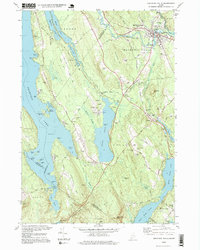 1995 Mechanic Falls1999 Print · USGSSouthern Maine in the mid-nineties shows a landscape of river-driven industry and growing lakefront communities at the meeting of three counties. Researchers can locate family sites near West Poland, trace the Grand Trunk RR, or find Highland Cem and Elm Street Sch.
 - 1996 Map of Brunswick, 2001 Print
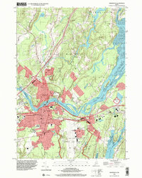 1996 Brunswick2001 Print · USGSCoastal Maine in the mid-nineties shows a mix of collegiate tradition and military readiness at the junction of the Androscoggin River. Genealogists and historians can trace family plots at Riverside Cem or study the campus layout of Bowdoin College.
 - 1997 Map of Orrs Island, 1999 Print
 1997 Orrs Island1999 Print · USGSCumberland County's intricate shoreline and island chains are shown here in the late nineties, from Harpswell Center down to the tip of Orrs Island. Researchers can find long-standing local landmarks like Union Ch, Cundys Harbor, and the Harpswell Islands Sch.
End of results
Showing maps 1-3 of 3
Top cities of Cumberland County
- Portland historical maps
- South Portland historical maps
- Scarborough historical maps
- Brunswick historical maps
- Westbrook historical maps
- Windham historical maps
See more
Frequently asked questions
- What are the different types of historical maps available for Cumberland County?
- What is the oldest map of Cumberland County?
- Where can I purchase historical maps of Cumberland County for my home or office?
- Where can I download high-res historical maps of Cumberland County?
- Are there historical topographic maps available for Cumberland County?
- Is there historical aerial imagery available for Cumberland County?
- Where are historical maps of Cumberland County sourced from?