1930s Maps of Osborn, Maine
Explore 4 historic maps of Osborn from the 1930s. These maps offer a rare glimpse into what life looked like during the 1930s — showing old roads, neighborhoods, homes, and landmarks that have changed or disappeared over time.
Whether you're researching your family's past, planning a metal detecting trip, or studying how Osborn's landscape evolved across the 1930s, these high-resolution maps are a powerful tool for exploring the history of this region.
- Focus on a specific era: All maps on this page are from the 1930s, giving you a focused view of this time period.
- See what’s changed: Compare century-old streets, trails, and buildings to today's modern landscape using overlays and satellite layers.
- Research with precision: Use these maps for genealogy, historical research, land use analysis, or educational projects.
- View, download, or print: Maps are fully viewable online in high resolution, and can be downloaded or printed for your own records.
Start exploring Osborn's history through authentic maps from the 1930s. This is your window into the past.
Osborn, ME maps
(4)- 1930 Map of Tunk Lake
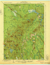
 1930 Tunk Lake1930 Print · USGSHancock County was a landscape of timber and tide in the early 1930s, where the Maine Central rail line linked small coastal villages to the deep woods. Genealogists and historians can trace old homesteads in Donnells, rural education at Tunk Lake Sch, and the locations of sporting retreats like the Wichyup Club.
 - 1932 Map of Tunk Lake
 1932 Tunk Lake1932 Print · USGSThe coastal inlets and glacial highlands of Hancock County are meticulously detailed in the early 1930s. Researchers can trace the Maine Central rail line through Sullivan and locate vanished local landmarks like the Think Lake Sch and Wickypup Club.4 unique versions available
 - 1932 Map of Lead Mountain
 1932 Lead Mountain1932 Print · USGSThe Maine timberlands and the historic Air Line Road are captured here in the early thirties, showcasing a landscape of isolated logging camps and remote lakes. Researchers can locate family-named sites like Howe Farm Camp, the settlements of Deblois and Beddington, and the Fire Tower atop Lead Mountain.5 unique versions available
 - 1932 Map of Great Pond
 1932 Great Pond1932 Print · USGSHancock and Penobscot Counties are captured here in the early thirties, showcasing the timberlands and small settlements along the Airline Road. Local historians can trace family roots through sites like the Goodwin School, Archers Corners, and North Mariaville.4 unique versions available
End of results
Showing maps 1-4 of 4
Top cities near Osborn
- Ellsworth historical maps
- Hancock historical maps
- Franklin historical maps
- Bradley historical maps
- Sullivan historical maps
- Clifton historical maps
See more
Top neighborhoods of Osborn
Frequently asked questions
- What are the different types of historical maps available for Osborn?
- What is the oldest map of Osborn?
- Where can I purchase historical maps of Osborn for my home or office?
- Where can I download high-res historical maps of Osborn?
- Are there historical topographic maps available for Osborn?
- Is there historical aerial imagery available for Osborn?
- Where are historical maps of Osborn sourced from?