1950s Maps of Osborn, Maine
Explore 5 historic maps of Osborn from the 1950s. These maps offer a rare glimpse into what life looked like during the 1950s — showing old roads, neighborhoods, homes, and landmarks that have changed or disappeared over time.
Whether you're researching your family's past, planning a metal detecting trip, or studying how Osborn's landscape evolved across the 1950s, these high-resolution maps are a powerful tool for exploring the history of this region.
- Focus on a specific era: All maps on this page are from the 1950s, giving you a focused view of this time period.
- See what’s changed: Compare century-old streets, trails, and buildings to today's modern landscape using overlays and satellite layers.
- Research with precision: Use these maps for genealogy, historical research, land use analysis, or educational projects.
- View, download, or print: Maps are fully viewable online in high resolution, and can be downloaded or printed for your own records.
Start exploring Osborn's history through authentic maps from the 1950s. This is your window into the past.
Osborn, ME maps
(5)- 1956 Map of Bangor, 1966 Print
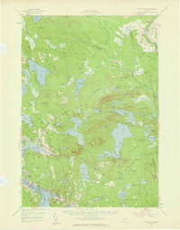
 1956 Bangor1966 Print · USGSMid-century Maine comes alive in this survey of the rugged coast and river valleys during the 1950s. Genealogists and historians can trace the vital rail corridors of the Maine Central RR connecting timber towns like Old Town to the coast at Bar Harbor.3 unique versions available
 - 1957 Map of Tunk Lake, 1959 Print
 1957 Tunk Lake1959 Print · USGSCoastal Maine in the late 1950s shows a landscape defined by the Maine Central RR and tidal waters like Hog Bay. Local historians can trace family locations near Bayview Cem, the Union Ch, and settlements from Deblois to East Sullivan.4 unique versions available
 - 1957 Map of Ellsworth, 1959 Print
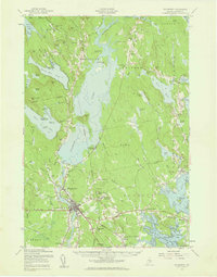 1957 Ellsworth1959 Print · USGSHancock County at the end of the fifties shows the critical transition from rail-dependent industry to the modern highway era. Researchers can trace historic family burial sites and rural schoolhouses, including Hillside Cem, Stetson Sch, and the junctions of the Maine Central Railroad.3 unique versions available
 - 1957 Map of Great Pond, 1959 Print
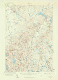 1957 Great Pond1959 Print · USGSHancock County's interior townships are shown here in the late fifties as military recreation and training sites integrated with traditional rural settlements. Researchers can locate the Hadley Cem and several community schools like Monticello Sch and Caruso Sch.4 unique versions available
 - 1957 Map of Lead Mountain, 1959 Print
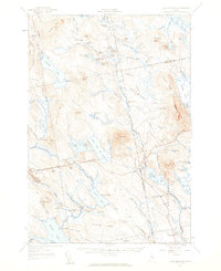 1957 Lead Mountain1959 Print · USGSThe wild lake country of Down East Maine is shown here in the late fifties, featuring the scattered outposts and high ridges of Washington and Hancock Counties. Genealogists and researchers can trace local landmarks like Beddington, Dog Corners, and the prominent Lookout Tower atop Lead Mtn.3 unique versions available
End of results
Showing maps 1-5 of 5
Top cities near Osborn
- Ellsworth historical maps
- Hancock historical maps
- Franklin historical maps
- Bradley historical maps
- Sullivan historical maps
- Clifton historical maps
See more
Top neighborhoods of Osborn
Frequently asked questions
- What are the different types of historical maps available for Osborn?
- What is the oldest map of Osborn?
- Where can I purchase historical maps of Osborn for my home or office?
- Where can I download high-res historical maps of Osborn?
- Are there historical topographic maps available for Osborn?
- Is there historical aerial imagery available for Osborn?
- Where are historical maps of Osborn sourced from?