1980s Maps of T16 MD BPP Township, Maine
Explore 5 historic maps of T16 MD BPP Township from the 1980s. These maps offer a rare glimpse into what life looked like during the 1980s — showing old roads, neighborhoods, homes, and landmarks that have changed or disappeared over time.
Whether you're researching your family's past, planning a metal detecting trip, or studying how T16 MD BPP Township's landscape evolved across the 1980s, these high-resolution maps are a powerful tool for exploring the history of this region.
- Focus on a specific era: All maps on this page are from the 1980s, giving you a focused view of this time period.
- See what’s changed: Compare century-old streets, trails, and buildings to today's modern landscape using overlays and satellite layers.
- Research with precision: Use these maps for genealogy, historical research, land use analysis, or educational projects.
- View, download, or print: Maps are fully viewable online in high resolution, and can be downloaded or printed for your own records.
Start exploring T16 MD BPP Township's history through authentic maps from the 1980s. This is your window into the past.
T16 MD BPP Township, ME maps
(5)- 1982 Map of Tunk Mountain, 1983 Print
 1982 Tunk Mountain1983 Print · USGSCoastal Maine's interior wetlands and granite peaks are documented in the early eighties as industry and nature intersected in the Deblois region. Genealogists and historians can trace family-named sites like Colson Branch Hill, the local Cem, and the old Spring River Dam.2 unique versions available
 - 1982 Map of Molasses Pond, 1983 Print
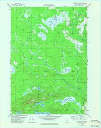
 1982 Molasses Pond1983 Print · USGSHancock County’s intricate interior wetlands and ridges are captured here during the early eighties. Researchers can trace land use through the Lyle Frost Wildlife Management Area and locate family landmarks like Crimmins Cem or Macomber Mill Str.
 - 1985 Map of Bangor
 1985 Bangor1985 Print · USGSMid-Maine during the mid-eighties centers on the industrial pulse of the Penobscot River and its critical rail connections. Genealogists and historians can trace the development of river towns from Old Town to Ellsworth and locate regional landmarks like Fort Knox State Park.
 - 1987 Map of Rocky Pond, 1988 Print
 1987 Rocky Pond1988 Print · USGSHancock County's interior ponds and river branches are captured here in the late eighties, showing a landscape shaped by water and timber. Researchers can trace landforms and landmarks like Dog Corners, the Sevenmile Brook Bluff, and the landings along the Union River.
 - 1987 Map of Lead Mountain, 1988 Print
 1987 Lead Mountain1988 Print · USGSThe remote interior of Washington County comes into focus in the late 1980s, centered on the lakes and ridges of the Narraguagus River valley. Researchers can trace local landmarks like Lower Beddington, the community Cem, and heights like Lead Mountain.
End of results
Showing maps 1-5 of 5
Top cities near T16 MD BPP Township
- Hancock historical maps
- Lamoine historical maps
- Gouldsboro historical maps
- Franklin historical maps
- Milbridge historical maps
- Sullivan historical maps
See more
Frequently asked questions
- What are the different types of historical maps available for T16 MD BPP Township?
- What is the oldest map of T16 MD BPP Township?
- Where can I purchase historical maps of T16 MD BPP Township for my home or office?
- Where can I download high-res historical maps of T16 MD BPP Township?
- Are there historical topographic maps available for T16 MD BPP Township?
- Is there historical aerial imagery available for T16 MD BPP Township?
- Where are historical maps of T16 MD BPP Township sourced from?