1950s Maps of Newburgh, Maine
Explore 5 historic maps of Newburgh from the 1950s. These maps offer a rare glimpse into what life looked like during the 1950s — showing old roads, neighborhoods, homes, and landmarks that have changed or disappeared over time.
Whether you're researching your family's past, planning a metal detecting trip, or studying how Newburgh's landscape evolved across the 1950s, these high-resolution maps are a powerful tool for exploring the history of this region.
- Focus on a specific era: All maps on this page are from the 1950s, giving you a focused view of this time period.
- See what’s changed: Compare century-old streets, trails, and buildings to today's modern landscape using overlays and satellite layers.
- Research with precision: Use these maps for genealogy, historical research, land use analysis, or educational projects.
- View, download, or print: Maps are fully viewable online in high resolution, and can be downloaded or printed for your own records.
Start exploring Newburgh's history through authentic maps from the 1950s. This is your window into the past.
Newburgh, ME maps
(5)- 1955 Map of Bucksport, 1957 Print
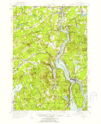 1955 Bucksport1957 Print · USGSThe Penobscot River valley thrives as a rail and maritime corridor during the mid-fifties, anchored by the industrial activities at Mt Waldo. Genealogists and historians can locate legacy family sites including Wiswell Cem, Nealys Corner, and the historic Fort Knox State Park.4 unique versions available
 - 1955 Map of Bangor, 1957 Print
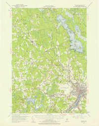 1955 Bangor1957 Print · USGSBangor and the surrounding Penobscot Valley are captured here in the mid-fifties, showing a landscape defined by riverside industry and lakefront life. Researchers can trace historic rail connections at Northern Maine Junction and locate family landmarks like Lakeside Ldg or Evergreen Cem.3 unique versions available
 - 1955 Map of Brooks, 1957 Print
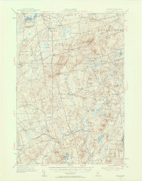 1955 Brooks1957 Print · USGSMid-century Waldo County is captured here as a network of rural hamlets and upland farms before modern development. Genealogists and historians can trace family locations through numerous named corners, country schools like Knowlton Sch, and local mills including Rollins Mills.4 unique versions available
 - 1955 Map of Stetson, 1957 Print
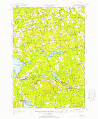 1955 Stetson1957 Print · USGSPenobscot County in the mid-1950s is shown as a thriving landscape of rural corner settlements and lakeside communities. Genealogists and historians can trace family lines through numerous rural burying grounds like Corinthian Cem or locate the site of the Longfellow Sch and Durham Bridge.3 unique versions available
 - 1956 Map of Bangor, 1966 Print
 1956 Bangor1966 Print · USGSMid-century Maine comes alive in this survey of the rugged coast and river valleys during the 1950s. Genealogists and historians can trace the vital rail corridors of the Maine Central RR connecting timber towns like Old Town to the coast at Bar Harbor.3 unique versions available
End of results
Showing maps 1-5 of 5
Top cities near Newburgh
- Bangor historical maps
- Orono historical maps
- Hampden historical maps
- Old Town historical maps
- Belfast historical maps
- Hermon historical maps
See more
Top neighborhoods of Newburgh
- Newburgh Center historical maps
- South Newburgh historical maps
- Arnold Corner historical maps
- North Newburgh historical maps
- Newburgh Village historical maps
Frequently asked questions
- What are the different types of historical maps available for Newburgh?
- What is the oldest map of Newburgh?
- Where can I purchase historical maps of Newburgh for my home or office?
- Where can I download high-res historical maps of Newburgh?
- Are there historical topographic maps available for Newburgh?
- Is there historical aerial imagery available for Newburgh?
- Where are historical maps of Newburgh sourced from?