Old Maps of Barnard Township, Maine for Academic Research
Study the evolution of Barnard Township with 28 high-resolution historic maps. Whether you're teaching, researching, or modeling changes in land use, these maps provide essential visual documentation of urban, environmental, and geographic change.
- Analyze long-term change: Track patterns in development, transportation, and natural features.
- Ideal for environmental or urban studies: Support academic projects with primary historical map data.
- Use in the classroom or lab: Educators and researchers rely on these maps to bring historical context to life.
These maps are a powerful tool for teaching, research, and visualizing how Barnard Township has changed over the decades.
Barnard Township, ME maps
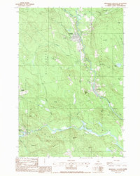
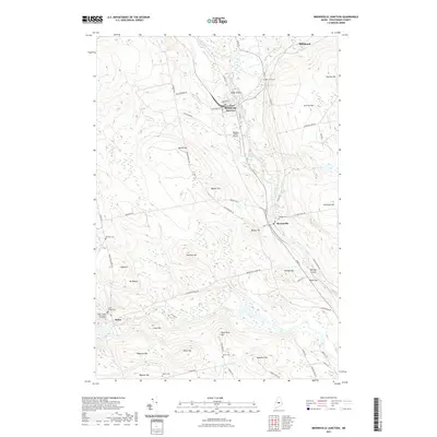
(28)- 1940 Map of Sebec
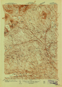 1940 Sebec1940 Print · USGSPiscataquis County in the early 1940s is captured here at a crossroads of the iron and timber industries. Researchers can locate the Katahdin Iron Works, trace the rail yards at Brownville Junction, and find rural schools like Williamsburg Sch.4 unique versions available
 - 1943 Map of Sebec
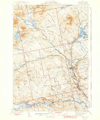 1943 Sebec1943 Print · USGSPiscataquis County in the early 1940s is a landscape of iron works, timber rails, and remote schools. Genealogists and historians can trace the paths of the CANADIAN PACIFIC railroad and locate sites like the Williamsburg Sch, Katahdin Iron Works, and Barnard Corner.4 unique versions available
 - 1954 Map of Millinocket, 1968 Print
 1954 Millinocket1968 Print · USGSMaine's North Woods and the Penobscot Valley are captured here during the mid-century era of logging and rail dominance. You can trace the path of the Bangor and Aroostook Railroad through timber towns like Millinocket, Mattawamkeag, and Silver Ridge.3 unique versions available
 - 1958 Map of Millinocket
 1958 Millinocket1958 Print · USGSMaine's North Woods and the Penobscot river valley are captured here in the mid-1950s, showing a landscape of timber, rail, and wild waters. Researchers can trace the legacy of the Canadian Pacific railroad and find historic settlements like Millinocket, Sherman Station, and Mattawamkeag.
 - 1960 Map of Millinocket
 1960 Millinocket1960 Print · USGSThe Maine North Woods and Penobscot River valley are captured at mid-century during the height of the paper milling era. Researchers can trace the Appalachian Trail near Mount Katardin or locate family roots in towns like Dover-Foxcroft and Milo.3 unique versions available
 - 1978 Map of Silver Lake, 1981 Print
 1978 Silver Lake1981 Print · USGSPiscataquis County in the late seventies is captured in this detailed aerial study of the Maine timberlands. Researchers can trace the exact shoreline of Silver Lake and find remote landmarks like Houston Mountain or the winding West Branch Pleasant River.
 - 1978 Map of Brownville Junction, 1981 Print
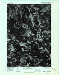 1978 Brownville Junction1981 Print · USGSThe Maine woods near the junction of the Piscataquis rivers are captured in the late seventies, showing the region's transition from wilderness to settlement. Genealogists and historians can trace the clearings of Barnard Corner or the riverbanks of West Branch Pleasant River.
 - 1978 Map of Sebec Lake East, 1981 Print
 1978 Sebec Lake East1981 Print · USGSPiscataquis County appears in the late seventies as a landscape of dense timber and quiet lakeside settlements. Researchers can trace the rural layout of Barnard and Bowerbank or study the natural hydrology of Sebec Lake and Long Bog.
 - 1986 Map of Dover-Foxcroft
 1986 Dover-Foxcroft1986 Print · USGSPiscataquis County at the edge of the great Maine woods is documented here in the mid-1980s, centered on the river-and-rail hubs of the interior. Trace the industrial footprints of Dover South Mills, the rail yards at Brownville Junction, or the historic Katahdin Iron Works.
 - 1988 Map of Silver Lake
 1988 Silver Lake1988 Print · USGSPiscataquis County's industrial and wilderness history meet in the late eighties near the Katahdin Iron Works State Park. Researchers can trace the geography of old timber grants and remote sporting camps like Pine Camp or the topography surrounding Silver Lake.
 - 1988 Map of Sebec Lake East
 1988 Sebec Lake East1988 Print · USGSThe eastern reach of Sebec Lake is captured here in the late 1980s, revealing a landscape defined by its deep coves and shoreline landings. Genealogists and researchers can trace the vicinity of Barnard and waterfront sites like Greeleys Landing or Parson Landing.2 unique versions available
 - 1988 Map of Brownville Junction
 1988 Brownville Junction1988 Print · USGSPiscataquis County timber and rail lands come into focus in the late eighties at the meeting of the two river branches. Genealogists and local historians can trace family-named landmarks like Town Farm Hill or the small settlement at Barnard Corner.
 - 1994 Map of Dover-Foxcroft
 1994 Dover-Foxcroft1994 Print · USGSCentral Maine in the mid-nineties shows a landscape of timber-driven towns and deep glacial lakes. Trace the paths of the Canadian Pacific RR or locate the Moscow Air Force Station Transmit Site and Sebec Lake.
 - 2011 Map of Brownville Junction, 2011 Print
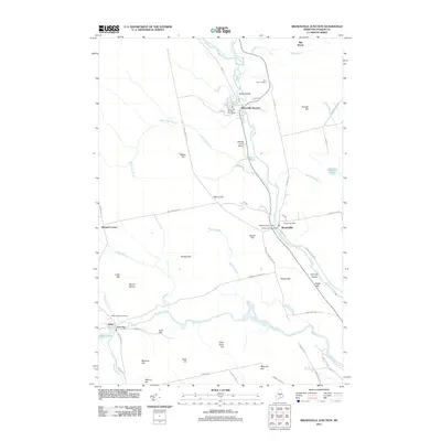 2011 Brownville Junction2011 Print · USGSCovers Barnard Township, including Milo, Brownville, and other nearby areas
 - 2011 Map of Silver Lake, 2011 Print
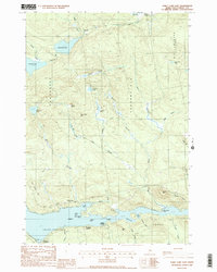
 2011 Silver Lake2011 Print · USGSCovers Barnard Township, including Bowerbank, Williamsburg Township, and other nearby areas
 - 2011 Map of Sebec Lake East, 2011 Print
 2011 Sebec Lake East2011 Print · USGSCovers Barnard Township, including Dover-Foxcroft, Sebec, and other nearby areas
 - 2014 Map of Silver Lake, 2014 Print
 2014 Silver Lake2014 Print · USGSCovers Barnard Township, including Bowerbank, Williamsburg Township, and other nearby areas
 - 2014 Map of Brownville Junction, 2014 Print
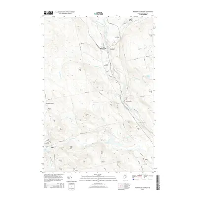 2014 Brownville Junction2014 Print · USGSCovers Barnard Township, including Milo, Brownville, and other nearby areas
 - 2014 Map of Sebec Lake East, 2014 Print
 2014 Sebec Lake East2014 Print · USGSCovers Barnard Township, including Dover-Foxcroft, Sebec, and other nearby areas
 - 2018 Map of Sebec Lake East, 2018 Print
 2018 Sebec Lake East2018 Print · USGSCovers Barnard Township, including Dover-Foxcroft, Sebec, and other nearby areas
 - 2018 Map of Brownville Junction, 2018 Print
 2018 Brownville Junction2018 Print · USGSCovers Barnard Township, including Milo, Brownville, and other nearby areas
 - 2018 Map of Silver Lake, 2018 Print
 2018 Silver Lake2018 Print · USGSCovers Barnard Township, including Bowerbank, Williamsburg Township, and other nearby areas
 - 2021 Map of Sebec Lake East, 2021 Print
 2021 Sebec Lake East2021 Print · USGSCovers Barnard Township, including Dover-Foxcroft, Sebec, and other nearby areas
 - 2021 Map of Brownville Junction, 2021 Print
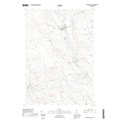
 2021 Brownville Junction2021 Print · USGSCovers Barnard Township, including Milo, Brownville, and other nearby areas
 - 2021 Map of Silver Lake, 2021 Print
 2021 Silver Lake2021 Print · USGSCovers Barnard Township, including Bowerbank, Williamsburg Township, and other nearby areas
Showing maps 1-25 of 28
Top cities near Barnard Township
- Dover-Foxcroft historical maps
- Milo historical maps
- Charleston historical maps
- Sangerville historical maps
- Guilford historical maps
- Bradford historical maps
See more
Top neighborhoods of Barnard Township
Frequently asked questions
- What are the different types of historical maps available for Barnard Township?
- What is the oldest map of Barnard Township?
- Where can I purchase historical maps of Barnard Township for my home or office?
- Where can I download high-res historical maps of Barnard Township?
- Are there historical topographic maps available for Barnard Township?
- Is there historical aerial imagery available for Barnard Township?
- Where are historical maps of Barnard Township sourced from?