1970s Maps of Blanchard Township, Maine
Explore 4 historic maps of Blanchard Township from the 1970s. These maps offer a rare glimpse into what life looked like during the 1970s — showing old roads, neighborhoods, homes, and landmarks that have changed or disappeared over time.
Whether you're researching your family's past, planning a metal detecting trip, or studying how Blanchard Township's landscape evolved across the 1970s, these high-resolution maps are a powerful tool for exploring the history of this region.
- Focus on a specific era: All maps on this page are from the 1970s, giving you a focused view of this time period.
- See what’s changed: Compare century-old streets, trails, and buildings to today's modern landscape using overlays and satellite layers.
- Research with precision: Use these maps for genealogy, historical research, land use analysis, or educational projects.
- View, download, or print: Maps are fully viewable online in high resolution, and can be downloaded or printed for your own records.
Start exploring Blanchard Township's history through authentic maps from the 1970s. This is your window into the past.
Blanchard Township, ME maps
(4)- 1975 Map of Kingsbury NE, 1980 Print
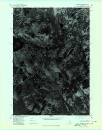
 1975 Kingsbury NE1980 Print · USGSThe woods and waters of Piscataquis County appear in stark detail in the mid-1970s before modern development altered these forest tracts. Researchers can trace the winding Piscataquis River and locate remote landmarks like Thorn Pond and Foss Pond.
 - 1975 Map of Kingsbury NW, 1980 Print
 1975 Kingsbury NW1980 Print · USGSCentral Maine forest land is captured in this mid-seventies aerial orthophoto, showing the remote timberlands of Somerset County. Trace the wild shorelines of Spectacle Pond and Palmer Pond or locate landmarks like Foss Hill Ridge.
 - 1977 Map of Monson West, 1981 Print
 1977 Monson West1981 Print · USGSPiscataquis County timberlands and lakeside settlements are documented here in the late seventies. Researchers can trace the layout of small communities like Shirley Mills and Monson or locate homesteads near Lake Hebron.
 - 1977 Map of Bald Mountain Pond, 1981 Print
 1977 Bald Mountain Pond1981 Print · USGSPiscataquis County timberlands are captured in this late-seventies aerial survey of the Maine woods near Shirley Mills. Researchers can trace the waterways of the West Branch Piscataquis River and the shores of Bald Mountain Pond.
End of results
Showing maps 1-4 of 4
Top cities near Blanchard Township
- Greenville historical maps
- Guilford historical maps
- Bingham historical maps
- Harmony historical maps
- Parkman historical maps
- Abbot historical maps
See more
Frequently asked questions
- What are the different types of historical maps available for Blanchard Township?
- What is the oldest map of Blanchard Township?
- Where can I purchase historical maps of Blanchard Township for my home or office?
- Where can I download high-res historical maps of Blanchard Township?
- Are there historical topographic maps available for Blanchard Township?
- Is there historical aerial imagery available for Blanchard Township?
- Where are historical maps of Blanchard Township sourced from?