1980s Maps of Blanchard Township, Maine
Explore 5 historic maps of Blanchard Township from the 1980s. These maps offer a rare glimpse into what life looked like during the 1980s — showing old roads, neighborhoods, homes, and landmarks that have changed or disappeared over time.
Whether you're researching your family's past, planning a metal detecting trip, or studying how Blanchard Township's landscape evolved across the 1980s, these high-resolution maps are a powerful tool for exploring the history of this region.
- Focus on a specific era: All maps on this page are from the 1980s, giving you a focused view of this time period.
- See what’s changed: Compare century-old streets, trails, and buildings to today's modern landscape using overlays and satellite layers.
- Research with precision: Use these maps for genealogy, historical research, land use analysis, or educational projects.
- View, download, or print: Maps are fully viewable online in high resolution, and can be downloaded or printed for your own records.
Start exploring Blanchard Township's history through authentic maps from the 1980s. This is your window into the past.
Blanchard Township, ME maps
(5)- 1986 Map of Dover-Foxcroft
 1986 Dover-Foxcroft1986 Print · USGSPiscataquis County at the edge of the great Maine woods is documented here in the mid-1980s, centered on the river-and-rail hubs of the interior. Trace the industrial footprints of Dover South Mills, the rail yards at Brownville Junction, or the historic Katahdin Iron Works.
 - 1989 Map of Bald Mtn Pond
 1989 Bald Mtn Pond1989 Print · USGSThe Maine wilderness in the late eighties is documented here, showing the remote township lines and high ridges of Piscataquis County. You can trace the Appalachian National Scenic Trail past Hatch Falls or locate the historic Shirley Mills and Cem.
 - 1989 Map of Monson West
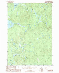
 1989 Monson West1989 Print · USGSIn the late eighties, this part of Piscataquis County retained its character as a hub for timber history and outdoor recreation. Researchers can trace the routes of the Appalachian National Scenic Trail or locate family sites in Monson, Blanchard, and Shirley Mills.
 - 1989 Map of Whetstone Pond
 1989 Whetstone Pond1989 Print · USGSPiscataquis County at the close of the 1980s is captured here as a landscape of isolated plantations and deep woods. Researchers can trace the quiet crossroads of Happy Corner and Cole Corner or locate seasonal sites around Whetstone Pond and Piper Pond.
 - 1989 Map of Foster Ridge
 1989 Foster Ridge1989 Print · USGSSomerset and Piscataquis counties meet in this backcountry landscape during the late eighties, a time when the region remained dominated by mountain ponds and unorganized plantations. You can trace the rugged topography of Foster Ridge and locate family-named landmarks like Hayden Pond or the extensive wetlands at Kingsley Bog.
End of results
Showing maps 1-5 of 5
Top cities near Blanchard Township
- Greenville historical maps
- Guilford historical maps
- Bingham historical maps
- Harmony historical maps
- Parkman historical maps
- Abbot historical maps
See more
Frequently asked questions
- What are the different types of historical maps available for Blanchard Township?
- What is the oldest map of Blanchard Township?
- Where can I purchase historical maps of Blanchard Township for my home or office?
- Where can I download high-res historical maps of Blanchard Township?
- Are there historical topographic maps available for Blanchard Township?
- Is there historical aerial imagery available for Blanchard Township?
- Where are historical maps of Blanchard Township sourced from?