1970s Maps of Unity, Maine
Explore 4 historic maps of Unity from the 1970s. These maps offer a rare glimpse into what life looked like during the 1970s — showing old roads, neighborhoods, homes, and landmarks that have changed or disappeared over time.
Whether you're researching your family's past, planning a metal detecting trip, or studying how Unity's landscape evolved across the 1970s, these high-resolution maps are a powerful tool for exploring the history of this region.
- Focus on a specific era: All maps on this page are from the 1970s, giving you a focused view of this time period.
- See what’s changed: Compare century-old streets, trails, and buildings to today's modern landscape using overlays and satellite layers.
- Research with precision: Use these maps for genealogy, historical research, land use analysis, or educational projects.
- View, download, or print: Maps are fully viewable online in high resolution, and can be downloaded or printed for your own records.
Start exploring Unity's history through authentic maps from the 1970s. This is your window into the past.
Unity, ME maps
(4)- 1975 Map of Burnham NE, 1980 Print
 1975 Burnham NE1980 Print · USGSWaldo County's rural landscape is captured from above in the mid-1970s, revealing the intricate patterns of forest and farmland. Researchers can trace the layout of small settlements like Greens Corner and Reynolds Corner near the shores of Unity Pond.
 - 1975 Map of Burnham SE, 1980 Print
 1975 Burnham SE1980 Print · USGSWaldo County at the height of the 1970s shows a landscape of enduring rural character and organized woodlots. Local historians can trace family locations and land use patterns around Unity, Freedom, and the crossroads at Knox Corner.
 - 1975 Map of Burnham SW, 1980 Print
 1975 Burnham SW1980 Print · USGSKennebec County as it appeared in the mid-seventies, showing the agricultural and forested landscape of central Maine. Genealogists and researchers can trace local landmarks like Albion, South Albion, and the winding Fifteenmile Stream.
 - 1975 Map of Burnham NW, 1980 Print
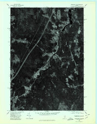 1975 Burnham NW1980 Print · USGSWaldo County and the Sebasticook River valley are captured in high-altitude detail during the mid-seventies. Genealogists and local historians can trace the precise layouts of Burnham, Winnecook, and Clinton as they appeared decades ago.
End of results
Showing maps 1-4 of 4
Top cities near Unity
- Winslow historical maps
- Vassalboro historical maps
- China historical maps
- Pittsfield historical maps
- Clinton historical maps
- Newport historical maps
See more
Top neighborhoods of Unity
Frequently asked questions
- What are the different types of historical maps available for Unity?
- What is the oldest map of Unity?
- Where can I purchase historical maps of Unity for my home or office?
- Where can I download high-res historical maps of Unity?
- Are there historical topographic maps available for Unity?
- Is there historical aerial imagery available for Unity?
- Where are historical maps of Unity sourced from?