1930s Maps of Washington County, Maine
Explore 11 historic maps of Washington County from the 1930s. These maps offer a rare glimpse into what life looked like during the 1930s — showing old roads, neighborhoods, homes, and landmarks that have changed or disappeared over time.
Whether you're researching your family's past, planning a metal detecting trip, or studying how Washington County's landscape evolved across the 1930s, these high-resolution maps are a powerful tool for exploring the history of this region.
- Focus on a specific era: All maps on this page are from the 1930s, giving you a focused view of this time period.
- See what’s changed: Compare century-old streets, trails, and buildings to today's modern landscape using overlays and satellite layers.
- Research with precision: Use these maps for genealogy, historical research, land use analysis, or educational projects.
- View, download, or print: Maps are fully viewable online in high resolution, and can be downloaded or printed for your own records.
Start exploring Washington County's history through authentic maps from the 1930s. This is your window into the past.
Washington County, ME maps
(11)- 1930 Map of Vanceboro
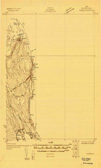 1930 Vanceboro1930 Print · USGSThe Maine and New Brunswick border comes alive in 1930, centering on the rail hub of Vanceboro and the St Croix River. Trace early 20th-century landmarks like the Cold Water Tavern, Camp Solitaire, and the intricate river rapids at Pork Rips.2 unique versions available
 - 1930 Map of Tunk Lake
 1930 Tunk Lake1930 Print · USGSHancock County was a landscape of timber and tide in the early 1930s, where the Maine Central rail line linked small coastal villages to the deep woods. Genealogists and historians can trace old homesteads in Donnells, rural education at Tunk Lake Sch, and the locations of sporting retreats like the Wichyup Club.
 - 1931 Map of Springfield
 1931 Springfield1931 Print · USGSPenobscot and Washington counties in the early 1930s reveal a landscape of ridges, bogs, and scattered timber camps. Genealogists can trace early rural life through features like Poplar Tavern Camp, the Dill Ridge Fire Tower, and numerous district schools like Cole Sch.4 unique versions available
 - 1931 Map of Robbinston
 1931 Robbinston1931 Print · USGSThe Maine coast near Robbinston and the Canadian border is captured here during the interwar years as a landscape of maritime navigation and rural communities. Genealogists can trace family landmarks and local schools like Bog Brook Sch, Shore Sch, and the riverside village of Red Beach.4 unique versions available
 - 1932 Map of Tunk Lake
 1932 Tunk Lake1932 Print · USGSThe coastal inlets and glacial highlands of Hancock County are meticulously detailed in the early 1930s. Researchers can trace the Maine Central rail line through Sullivan and locate vanished local landmarks like the Think Lake Sch and Wickypup Club.4 unique versions available
 - 1932 Map of Calais
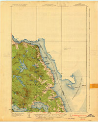
 1932 Calais1932 Print · USGSCoastal Washington County at the start of the 1930s is defined by the international river border and the busy corridors of the Maine Central RR. Genealogists and local historians can locate old rural schoolhouses like Damon Sch or trace the timber-and-rail industry through Woodland Junc and Young Siding.4 unique versions available
 - 1932 Map of Nicatous Lake
 1932 Nicatous Lake1932 Print · USGSNicatous Lake and the surrounding Maine wilderness are captured here in the early 1930s, when private sporting retreats and seasonal camps dotted the shoreline. Genealogists and local historians can trace specific locations like the Explorers Club, Adler Tavern Camp, and Sullivan Camp.4 unique versions available
 - 1932 Map of Lead Mountain
 1932 Lead Mountain1932 Print · USGSThe Maine timberlands and the historic Air Line Road are captured here in the early thirties, showcasing a landscape of isolated logging camps and remote lakes. Researchers can locate family-named sites like Howe Farm Camp, the settlements of Deblois and Beddington, and the Fire Tower atop Lead Mountain.5 unique versions available
 - 1933 Map of Vanceboro
 1933 Vanceboro1933 Print · USGSVanceboro and the Canadian borderlands are captured here in the early 1930s as the rail and river economy flourished. Genealogists and historians can trace the Maine Central rail lines and locate early landmarks like Ice House Pt, Sussie Hill, and Lambert Lake.4 unique versions available
 - 1934 Map of Nicatous Lake
 1934 Nicatous Lake1934 Print · USGSHancock County was a landscape of remote sporting camps and timber trails in the early 1930s. Genealogists and historians can trace old sites like Poplar Tavern Camp, the Nicatous Club, and No 2 Camp set among landmarks like Duck Mtn.4 unique versions available
 - 1934 Map of Springfield
 1934 Springfield1934 Print · USGSPenobscot County in the 1930s is a landscape of rural schoolhouses and timberlands surrounding Springfield and Carroll. Genealogists and historians can trace family-named locations such as Tolman Sch, Gowell Sch, and Bridge Farm.4 unique versions available
End of results
Showing maps 1-11 of 11
Top cities of Washington County
- Calais historical maps
- Machias historical maps
- Milbridge historical maps
- East Machias historical maps
- Baileyville historical maps
- Eastport historical maps
See more
Frequently asked questions
- What are the different types of historical maps available for Washington County?
- What is the oldest map of Washington County?
- Where can I purchase historical maps of Washington County for my home or office?
- Where can I download high-res historical maps of Washington County?
- Are there historical topographic maps available for Washington County?
- Is there historical aerial imagery available for Washington County?
- Where are historical maps of Washington County sourced from?