1990s Maps of Washington County, Maine
Explore 27 historic maps of Washington County from the 1990s. These maps offer a rare glimpse into what life looked like during the 1990s — showing old roads, neighborhoods, homes, and landmarks that have changed or disappeared over time.
Whether you're researching your family's past, planning a metal detecting trip, or studying how Washington County's landscape evolved across the 1990s, these high-resolution maps are a powerful tool for exploring the history of this region.
- Focus on a specific era: All maps on this page are from the 1990s, giving you a focused view of this time period.
- See what’s changed: Compare century-old streets, trails, and buildings to today's modern landscape using overlays and satellite layers.
- Research with precision: Use these maps for genealogy, historical research, land use analysis, or educational projects.
- View, download, or print: Maps are fully viewable online in high resolution, and can be downloaded or printed for your own records.
Start exploring Washington County's history through authentic maps from the 1990s. This is your window into the past.
Washington County, ME maps
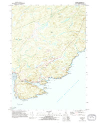
(27)- 1990 Map of Montegail Pond
 1990 Montegail Pond1990 Print · USGSWashington County, Maine, is shown here in the late twentieth century as a landscape of military installations and deep woods. Trace the footprint of the Columbia Falls Air Force Station or find local landmarks like Brewster Corner and the Six Mile Dam (Site).
 - 1990 Map of Bog Lake
 1990 Bog Lake1990 Print · USGSThe interior of Washington County comes into focus in the 1990s, where the winding Machias River meets a vast system of glacial ponds and ridges. Historians can trace the local water economy through features like Bobsled Rips, Smith Landing, and the Cem at Northfield.
 - 1990 Map of Northeast Bluff
 1990 Northeast Bluff1990 Print · USGSEastern Maine's interior reaches are documented here during the late twentieth century, showing a remote landscape of the Bingham Purchase. Researchers can trace the drainages of the Pleasant River and locate landmarks like Dorman Island, Northeast Bluff, and Spruce Ridge.
 - 1990 Map of Round Lake
 1990 Round Lake1990 Print · USGSWashington County’s river-and-lake wilderness is captured here in the late twentieth century, showing a landscape shaped by water and woods. Genealogists and historians can trace family-named landmarks like Joe Hanscom Heath, Talbot Ridge, and Munson Rips.
 - 1990 Map of Big Lake
 1990 Big Lake1990 Print · USGSThe Indian Twp Indian Reservation and surrounding plantations are shown in detail during the late twentieth century. Researchers can locate the Peter Dana Point settlement, the Cem, and remote landings like Greenlaw Chopping Landing.
 - 1990 Map of Clifford Lake
 1990 Clifford Lake1990 Print · USGSWashington County, Maine, in the late twentieth century is a landscape of expansive waters and ridges. Genealogists and outdoorsmen can trace the shores of Clifford Lake and locate specific sites like Carloe Pond, Love Ridge, and the Plantation No 21 border.
 - 1990 Map of Wesley
 1990 Wesley1990 Print · USGSWashington County’s timber and lake country is captured here during the late twentieth century. Genealogists and researchers can trace local landmarks like the Wesley Fire Tower, the small settlement at The Pines, and family-named waters such as Dudley Brook.
 - 1990 Map of Dark Cove Mountain
 1990 Dark Cove Mountain1990 Print · USGSThe interconnected lakes of Washington County are shown in great detail during the late twentieth century, before the digital age reshaped backcountry navigation. Trace historical water routes and portages including Dennison Portage, Dobsis Dam, and the landing at Elsemore Landing.
 - 1990 Map of Princeton
 1990 Princeton1990 Print · USGSThe interconnected waterways of Washington County are captured here in the late twentieth century, centered on the lakeside town of Princeton. Researchers can trace old property lines and landmarks from Pocomoonshine Mountain to the Indian Twp Indian Reservation.
 - 1990 Map of Peaked Mountain Pond
 1990 Peaked Mountain Pond1990 Print · USGSWashington County, Maine, is shown in the early 1990s as a landscape of winding rivers and remote timberlands. Researchers can trace the path of the Machias River to find landmarks like Holmes Falls, Mattimo Place, and The Oxbow.
 - 1990 Map of Monroe Lake
 1990 Monroe Lake1990 Print · USGSWashington County’s interior waterways are captured here in the late twentieth century, showing a remote landscape of interconnected lakes and timberlands. Researchers can trace the flow of the Machias River through Second Machias Lake and locate specific features like Hay Meadows and Getchel Mountain.
 - 1990 Map of Fletcher Peak
 1990 Fletcher Peak1990 Print · USGSWashington County’s interior lake country is shown in the early nineties, characterized by high timbered peaks and isolated waters. Researchers can trace land divisions and landmark elevations like Fletcher Peak, the Lookout Tower, and Third Machias Lake.
 - 1990 Map of Tug Mountain
 1990 Tug Mountain1990 Print · USGSWashington County’s interior timberlands were largely unorganized territory in the late twentieth century. You can trace the hydrology of the Machias River while locating landmarks like Canaan Dam, Tug Mountain, and Kerosene Pond.
 - 1990 Map of Crawford Lake
 1990 Crawford Lake1990 Print · USGSCrawford and the surrounding Down East timberlands are captured here in the 1980s, showcasing a landscape of vast lakes and interconnected streams. Researchers can trace the water-bound borders of Plantation No 21 or locate local landmarks like Great Pine Point and the Gravel Pit.
 - 1990 Map of Peaked Mountain
 1990 Peaked Mountain1990 Print · USGSThe Maine North Woods in the early nineties reveal a landscape of vast water networks and timber ridges across Washington and Hancock counties. Researchers can trace the drainage of Lower Cranberry Lake and locate landforms like Peaked Mountain and Tibbetts Ridge.
 - 1990 Map of Grand Lake Stream
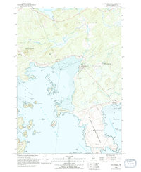
 1990 Grand Lake Stream1990 Print · USGSMaine's Washington County backcountry is captured here in the late twentieth century, centered on the historic timber and fishing hub at the outlet of West Grand Lake. Researchers can trace the grounds of the Grand Lake Stream State Fish Hatchery and numerous landmarks like Wabassus Mountain and Jumbo Landing.
 - 1993 Map of Machias Seal Island South, 1995 Print
 1993 Machias Seal Island South1995 Print · USGSCoastal waters south of the Maine-New Brunswick border are the focus of this maritime survey in the early nineties. Researchers and maritime historians can locate Machias Seal Island and trace the open waters of the Gulf of Maine.
 - 1993 Map of Machias Seal Island, 1995 Print
 1993 Machias Seal Island1995 Print · USGSCoastal Washington County and the maritime boundary waters are captured here in the early nineties. Maritime researchers can locate the Lighthouse on Machias Seal Island and identify the nearby North Rock amidst the Grand Manan Channel.
 - 1993 Map of Moose River, 1995 Print
 1993 Moose River1995 Print · USGSThe Washington County coastline in the early nineties reveals a landscape of tidal ledges and secluded coves where the Moose River meets the sea. Researchers can trace the shoreline of Cutler, from the depths of Norse Pond to the open waters of the Grand Manan Channel.
 - 1993 Map of Cutler, 1995 Print
 1993 Cutler1995 Print · USGSThe Washington County coastline in the early nineties reveals a landscape of protected harbors and rocky heads. Genealogists and maritime historians can locate the Old Cutler Cem, the Head of the River Ch, and the iconic Lighthouse on Little River Island.2 unique versions available
 - 1993 Map of Old Man, 1995 Print
 1993 Old Man1995 Print · USGSThe coastal waters of Washington County are captured here in the early nineties, centered on the strategic Grand Manan Channel. Maritime researchers can identify specific hazards like Flowers Rock and the island acreage of the Cross Island National Wildlife Refuge.
 - 1993 Map of Cross Island, 1995 Print
 1993 Cross Island1995 Print · USGSCoastal Washington County is captured here in the early nineties, centered on the protected lands of the Cross Island National Wildlife Refuge. Maritime researchers can locate the Lighthouse at Libby Islands and the US Naval Communication Unit near Thornton Point.
 - 1993 Map of Machias Bay, 1995 Print
 1993 Machias Bay1995 Print · USGSCoastal Washington County in the 1990s reveals a landscape shaped by military infrastructure and maritime conservation. Trace the restricted grounds of the U S Naval Communication Unit or explore the islands of the Cross Island National Wildlife Refuge and the harbor at North Cutler.2 unique versions available
 - 1994 Map of Calais
 1994 Calais1994 Print · USGSEastern Maine's river and lake country comes into focus in the 1990s, centered on the international border at Calais and the vast Passamaquoddy Indian Reservation. Researchers can trace the water-linked settlements of Grand Lake Stream, the airfield at Princeton Airport, and the industrial heritage of Woodland.
 - 1994 Map of Bangor
 1994 Bangor1994 Print · USGSThe Penobscot River valley and the coastal highlands of eastern Maine are captured here in the mid-1990s. Researchers can trace the industrial rail corridors of the Maine Central Railroad or explore the landscape around Old Town, Bucksport, and Graham Lake.
Showing maps 1-25 of 27
Top cities of Washington County
- Calais historical maps
- Machias historical maps
- Milbridge historical maps
- East Machias historical maps
- Baileyville historical maps
- Eastport historical maps
See more
Frequently asked questions
- What are the different types of historical maps available for Washington County?
- What is the oldest map of Washington County?
- Where can I purchase historical maps of Washington County for my home or office?
- Where can I download high-res historical maps of Washington County?
- Are there historical topographic maps available for Washington County?
- Is there historical aerial imagery available for Washington County?
- Where are historical maps of Washington County sourced from?