1980s Maps of Washington County, Maine
Explore 45 historic maps of Washington County from the 1980s. These maps offer a rare glimpse into what life looked like during the 1980s — showing old roads, neighborhoods, homes, and landmarks that have changed or disappeared over time.
Whether you're researching your family's past, planning a metal detecting trip, or studying how Washington County's landscape evolved across the 1980s, these high-resolution maps are a powerful tool for exploring the history of this region.
- Focus on a specific era: All maps on this page are from the 1980s, giving you a focused view of this time period.
- See what’s changed: Compare century-old streets, trails, and buildings to today's modern landscape using overlays and satellite layers.
- Research with precision: Use these maps for genealogy, historical research, land use analysis, or educational projects.
- View, download, or print: Maps are fully viewable online in high resolution, and can be downloaded or printed for your own records.
Start exploring Washington County's history through authentic maps from the 1980s. This is your window into the past.
Washington County, ME maps
(45)- 1982 Map of Tunk Mountain, 1983 Print
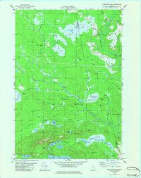 1982 Tunk Mountain1983 Print · USGSCoastal Maine's interior wetlands and granite peaks are documented in the early eighties as industry and nature intersected in the Deblois region. Genealogists and historians can trace family-named sites like Colson Branch Hill, the local Cem, and the old Spring River Dam.2 unique versions available
 - 1982 Map of Tunk Lake, 1983 Print
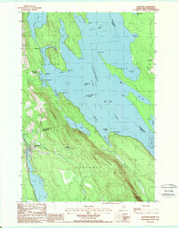
 1982 Tunk Lake1983 Print · USGSHancock and Washington Counties are captured in the early 1980s, centered on the vast waters of Tunk Lake. Researchers can trace the path of the Maine Central railroad and locate historical sites like Big Chief Camps or Goodwin Siding.
 - 1984 Map of Schoodic Lake, 1985 Print
 1984 Schoodic Lake1985 Print · USGSWashington County in the late 1970s and early 80s shows a landscape of blueberry production and wild river corridors. Trace family landmarks and local history through the Morse Cem, the Deblois Flight Strip, and the shores of Schoodic Lake.2 unique versions available
 - 1984 Map of Epping, 1985 Print
 1984 Epping1985 Print · USGSCoastal Washington County in the late seventies is captured here, showing a landscape defined by vast peatlands and small river settlements. Researchers can locate Columbia Cem, the Little River Ch, and the winding Pleasant River through the Great Heath.2 unique versions available
 - 1985 Map of Bangor
 1985 Bangor1985 Print · USGSMid-Maine during the mid-eighties centers on the industrial pulse of the Penobscot River and its critical rail connections. Genealogists and historians can trace the development of river towns from Old Town to Ellsworth and locate regional landmarks like Fort Knox State Park.
 - 1985 Map of Millinocket, 1986 Print
 1985 Millinocket1986 Print · USGSThe North Maine Woods were a landscape of industrial timber and wilderness recreation in the mid-eighties. Genealogists and researchers can trace local settlements and rail stops like Sherman Mills, Wytopitlock, and the Old Long A Siding near the Penobscot River.2 unique versions available
 - 1985 Map of Machias, 1986 Print
 1985 Machias1986 Print · USGSThe Downeast coast of Maine in the 1980s reveals a landscape of deep-water bays, tidal rivers, and isolated timberlands. Researchers can trace the Maine Central rail line and locate coastal landmarks from Leighton Point to the U.S. Naval Radio Station.
 - 1985 Map of Lincoln, 1994 Print
 1985 Lincoln1994 Print · USGSPenobscot County in the mid-eighties remains a landscape of river-based commerce and sprawling timberlands connected by rail. You can trace the historic paths of the Maine Central RR and Canadian Pacific RR or locate rural sites like Enfield Station and the Winn Cem.
 - 1986 Map of Eastport
 1986 Eastport1986 Print · USGSThe easternmost edge of the United States is captured in the mid-1980s, documenting the maritime border with Canada. Trace the coastal topography of Eastport and Lubec, including the Lighthouse at West Quoddy Head and the shoreline of Johnson Bay.2 unique versions available
 - 1986 Map of Calais
 1986 Calais1986 Print · USGSCoastal and interior Washington County are captured here in the mid-1980s, where the international border follows the winding St Croix River. Genealogists and historians can trace the rail lines of the Maine Central and find landmarks like Red Beach and Princeton Airport.
 - 1986 Map of Lincoln
 1986 Lincoln1986 Print · USGSMid-century Maine settlement and industry converge along the Penobscot and Piscataquis rivers during the 1980s. Researchers can trace the rail networks of the Maine Central and Bangor and Aroostook through towns like Howland and Milo.
 - 1986 Map of Petit Manan Point
 1986 Petit Manan Point1986 Print · USGSThe Downeast Maine coastline in the mid-eighties was a complex landscape of harbors and island chains. Genealogists and historians can trace coastal settlements and maritime landmarks like the Lighthouse on Petit Manan Point and the islands of Mistake Harbor.2 unique versions available
 - 1987 Map of Porcupine Mountain
 1987 Porcupine Mountain1987 Print · USGSIn the late twentieth century, this Washington County landscape was a mosaic of timberlands and river rapids. Genealogists and historians can trace old boundaries at No 14 Plot or locate family-named landmarks like Gilman Dam, Birch Hill, and Pine Corner.
 - 1987 Map of Meddybemps Lake West
 1987 Meddybemps Lake West1987 Print · USGSWashington County at the start of the 1980s reveals a quiet landscape of interior lakes and isolated settlements. Researchers can locate family landmarks like Howe and Cedar, or trace old routes passing by Kendall Mtn and Meddybemps Lake.
 - 1987 Map of Woodland
 1987 Woodland1987 Print · USGSThe international border along the St Croix River comes into focus during the late twentieth century, showing the industrial core of Woodland. Genealogists and historians can trace local landmarks like Woodland Junction, South Princeton, and the rural settlements of Upper and Lower Little Ridge.
 - 1987 Map of Long Lake, 1988 Print
 1987 Long Lake1988 Print · USGSCoastal Washington County is shown here in the late eighties, a land defined by intricate waterways and small mill settlements. Researchers can locate family landmarks at Chase Mills and Halls Mills, or trace the winding course of the East Machias River and Rocky Lake.
 - 1987 Map of Lake Cathance, 1988 Print
 1987 Lake Cathance1988 Print · USGSThe interior lakes and timberlands of Washington County are captured here in the late eighties. Researchers can trace land divisions across Cooper and No 14 Plt or locate family landmarks like Conner Hill and Provost Island.
 - 1987 Map of Meddybemps Lake East, 1988 Print
 1987 Meddybemps Lake East1988 Print · USGSMeddybemps and the surrounding Maine lake country are documented here in the late twentieth century. Genealogists and local historians can trace family locations near Meddybemps village and Blanchard Corner or locate the lakeside Cem.
 - 1987 Map of Hadley Lake, 1988 Print
 1987 Hadley Lake1988 Print · USGSCoastal Washington County's interior is captured in the late eighties, showing a landscape of glacial lakes and interconnected waterways. Researchers can locate the village of Jacksonville and trace the drainage of Hadley Lake into the East Machias River.
 - 1987 Map of Duck Lake, 1988 Print
 1987 Duck Lake1988 Print · USGSThe Maine woods at the edge of Washington County in the 1980s are defined by a complex labyrinth of interconnected waterways and timberlands. Trace the remote drainages of Duck Lake and Sysladobsis Lake, or locate family landmarks near Lakeville and Duck Mtn.
 - 1987 Map of Quillpig Mountain, 1988 Print
 1987 Quillpig Mountain1988 Print · USGSHancock County and the Washington County border are captured here in the late eighties, showing a landscape of deep woods and interconnected waterways. Outdoor enthusiasts and local historians can trace the course of the Narraguagus River, find remote spots like Twentyeight Pond, or locate the shores of Mopang Lake.
 - 1987 Map of Gassabias Lake, 1988 Print
 1987 Gassabias Lake1988 Print · USGSThe unorganized territories of Hancock and Washington counties are documented here in the late 1980s, showing a vast Maine timberland before significant modern change. Trace the primitive roads and water routes connecting Gassabias Lake, Upper Sabao Lake, and Sabao Mountain.
 - 1987 Map of Lead Mountain, 1988 Print
 1987 Lead Mountain1988 Print · USGSThe remote interior of Washington County comes into focus in the late 1980s, centered on the lakes and ridges of the Narraguagus River valley. Researchers can trace local landmarks like Lower Beddington, the community Cem, and heights like Lead Mountain.
 - 1988 Map of Danforth
 1988 Danforth1988 Print · USGSThe Maine-New Brunswick borderlands are shown here in the late eighties, where the town of Danforth meets the expansive Chiputneticook Grand Lake. Researchers can trace old property lines and local landmarks like the Grand Lake Grange, Flagstaff, and Weston.
 - 1988 Map of Potter Hill
 1988 Potter Hill1988 Print · USGSMaine's north woods and plantations come into focus in the late 1980s, showcasing a landscape of timbered ridges and winding waterways. Researchers can locate the Cem in Prentiss Plt and trace family-named landmarks like Sam Rowe Ridge and Potter Hill.
Showing maps 1-25 of 45
Top cities of Washington County
- Calais historical maps
- Machias historical maps
- Milbridge historical maps
- East Machias historical maps
- Baileyville historical maps
- Eastport historical maps
See more
Frequently asked questions
- What are the different types of historical maps available for Washington County?
- What is the oldest map of Washington County?
- Where can I purchase historical maps of Washington County for my home or office?
- Where can I download high-res historical maps of Washington County?
- Are there historical topographic maps available for Washington County?
- Is there historical aerial imagery available for Washington County?
- Where are historical maps of Washington County sourced from?