1950s Maps of Washington County, Maine
Explore 33 historic maps of Washington County from the 1950s. These maps offer a rare glimpse into what life looked like during the 1950s — showing old roads, neighborhoods, homes, and landmarks that have changed or disappeared over time.
Whether you're researching your family's past, planning a metal detecting trip, or studying how Washington County's landscape evolved across the 1950s, these high-resolution maps are a powerful tool for exploring the history of this region.
- Focus on a specific era: All maps on this page are from the 1950s, giving you a focused view of this time period.
- See what’s changed: Compare century-old streets, trails, and buildings to today's modern landscape using overlays and satellite layers.
- Research with precision: Use these maps for genealogy, historical research, land use analysis, or educational projects.
- View, download, or print: Maps are fully viewable online in high resolution, and can be downloaded or printed for your own records.
Start exploring Washington County's history through authentic maps from the 1950s. This is your window into the past.
Washington County, ME maps
(33)- 1950 Map of Drisko Island
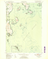
 1950 Drisko Island1950 Print · USGSCoastal Washington County is shown here during the mid-century, mapping the intricate islands and ledges between Pleasant Bay and the Atlantic. Mariners and local historians can trace maritime landmarks like Big Nash Island, Cape Split Harbor, and the Tibbett Narrows.
 - 1950 Map of Petit Manan
 1950 Petit Manan1950 Print · USGSCoastal Washington and Hancock counties are seen here at mid-century, defined by lobster harbors and the shifting tides of the Atlantic. Researchers can trace family names and local landmarks from Corea to Dyer Harbor, including the Corea Cem and Long Mill Cove.
 - 1950 Map of Cherryfield
 1950 Cherryfield1950 Print · USGSThe Narraguagus River valley and the coastal harbors of Washington County are shown here in the years following World War II. Local historians can trace the Maine Central railroad line through Unionville and Cherryfield, or locate family sites near Evergreen Cem and Steuben Harbor.
 - 1950 Map of Bois Bubert
 1950 Bois Bubert1950 Print · USGSThe Maine coastline near Addison and Harrington is captured here at the mid-century, showing a maritime landscape of islands and harbors. Researchers can trace family-named landmarks like Tom Leighton Point and find offshore aids like the lighthouse.3 unique versions available
 - 1950 Map of Cross Island
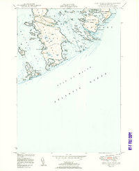
 1950 Cross Island1950 Print · USGSThe Washington County coast at the midpoint of the century is defined by its maritime outposts and hazardous ledges. Trace the legacy of coastal safety at the Cross Island Coast Guard Sta and the Lighthouse on the Libby Islands.
 - 1950 Map of Petit Manan
 1950 Petit Manan1950 Print · USGSThe Downeast shoreline around Corea and Pigeon Hill is captured here at the mid-century, before modern development changed the coast. Trace family roots at Corea Cem and explore the historic Carrying Place between the harbor and the sea.
 - 1950 Map of Great Wass Island
 1950 Great Wass Island1950 Print · USGSThe Washington County coast in the post-war era reveals a landscape of isolated farmsteads and vital maritime outposts. Researchers can trace the layout of Mannings Farm, the telephone line through the brush, and the Moose Peak Coast Guard station.3 unique versions available
 - 1951 Map of Machias
 1951 Machias1951 Print · USGSCoastal Washington County is captured here in the early fifties, showing the vital rail-and-sea connections of Machias. Genealogists and historians can trace family locations in Dog Town, locate the Longfellow Cem, or explore the grounds of Fort O'Brien Pt.
 - 1951 Map of Addison
 1951 Addison1951 Print · USGSCoastal Washington County is depicted here in the early fifties, showing the intricate tidal network of the Downeast shore. Researchers can trace the layout of waterfront communities like South Addison and locate vanished landmarks such as the Upper East Side School.
 - 1951 Map of West Lubec
 1951 West Lubec1951 Print · USGSCoastal Washington County at mid-century reveals a land of tidal coves and small harbor settlements before modern development reshaped the Maine shore. Genealogists and historians can trace family roots through landmarks like West Lubec Cem, Baptist Ch, and South Trescott.
 - 1951 Map of Moose River
 1951 Moose River1951 Print · USGSThe coastal edge of Washington County meets the sea in the early fifties, showing a landscape of maritime navigation and sparse settlement. Trace the small community around the Moose River School and the rocky shoreline of Eastern Head.
 - 1951 Map of Harrington
 1951 Harrington1951 Print · USGSCoastal Washington County is captured here in the mid-century, showcasing a landscape of tidal inlets and small Down East villages. Researchers can locate family landmarks like Rock Maple Cem, the Union Ch, and rural schoolhouses including Marshville Sch.2 unique versions available
 - 1951 Map of Cutler
 1951 Cutler1951 Print · USGSThe Downeast coast of Maine in the early 1950s reveals a maritime landscape centered on the sheltered harbor of Cutler. Researchers can trace the layout of early settlements and coastal landmarks, from the Little River Lighthouse to the Head of the River Ch and Little Machias Sch.2 unique versions available
 - 1951 Map of Columbia Falls
 1951 Columbia Falls1951 Print · USGSCoastal Washington County during the mid-century period shows a landscape defined by timber, rail, and the tides. Genealogists and historians can trace family locations near Columbia Falls, Jonesboro Station, and the heights of Milton Mtn.
 - 1951 Map of Whitneyville
 1951 Whitneyville1951 Print · USGSThe coastal inlets and timberlands of Washington County come alive in this mid-century survey of Jonesboro and Whitneyville. Researchers can trace the path of the Maine Central railroad and locate old landmarks like the White School or Mt Misery.
 - 1951 Map of Jonesport
 1951 Jonesport1951 Print · USGSCoastal Washington County at mid-century reveals a landscape of seafaring villages and intricate tidal waterways. Researchers can trace genealogical roots through landmarks like the Kelley School, Greenwood Cem, and the settlement of Monsonpec.2 unique versions available
 - 1951 Map of Machias Bay
 1951 Machias Bay1951 Print · USGSThe Maine coast in the early fifties shows a landscape of tidal flats and rocky points between Holmes Bay and Little Machias Bay. Genealogists and historians can locate the Holmes Bay Ch, the settlement at North Cutler, and family-named landmarks like Pettegrove Mtn.
 - 1951 Map of Roque Bluffs
 1951 Roque Bluffs1951 Print · USGSThe Maine coastline near Roque Bluffs appears here in the early fifties, showing a maritime landscape of intricate bays and isolated islands. Researchers can trace coastal landmarks like Starboard, the heights of Johnson Mtn, and the dangerous shoals around The Brothers.
 - 1952 Map of Big Lake
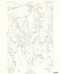
 1952 Big Lake1952 Print · USGSIn the early fifties, the lake country of Washington County remained a maze of waterways and remote townships. Genealogists can trace family footprints at Dixie School, the Indian Township reservation, and the lakeside settlement of Princeton.
 - 1952 Map of Lubec
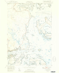
 1952 Lubec1952 Print · USGSThe easternmost tip of the United States meets the Canadian border in the early fifties at this maritime crossroads. Genealogists and maritime historians can trace the docks at Lubec, the U S Coast Guard Sta No 1, and numerous family-named landmarks like Charleys Pt.
 - 1953 Map of Cutler
 1953 Cutler1953 Print · USGSThe Washington County coast was a network of fishing harbors and small school districts in the early 1950s. Genealogists can trace family landmarks and burial sites like the Old Cutler Cem, Little Machias Sch, and the isolated Little River Lighthouse.
 - 1953 Map of Bois Bubert
 1953 Bois Bubert1953 Print · USGSCoastal Washington County is seen here in the early 1950s, a period defined by its intricate network of islands and working waterfronts. Researchers can trace historic maritime landmarks and family-named points like Tom Leighton Point, Jordans Delight, and the Trafton Halftide Beacon.
 - 1953 Map of Columbia Falls
 1953 Columbia Falls1953 Print · USGSCoastal Washington County is captured here in the early fifties, showing the rail-and-river economy of the Downeast region. Genealogists can locate the Central District and Columbia Falls settlement, while tracing the old Maine Central rail line.
 - 1953 Map of Wabassus Lake, 1984 Print
 1953 Wabassus Lake1984 Print · USGSMaine's wilderness townships come to life in this mid-century survey of the interconnected waterways north of the Machias River. Researchers can trace historic forest service landmarks like the State Forest Service Camp or locate the village of Grand Lake Stream and its local cemetery.
 - 1954 Map of Calais
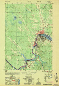 1954 Calais1954 Print · USGSIn the mid-1950s, the international border at Calais was a bustling corridor of rail and river industry. Researchers can trace the legacy of timber and transport through sites like Union Mills, the Canadian Pacific line, and Campbells Siding.
Showing maps 1-25 of 33
Top cities of Washington County
- Calais historical maps
- Machias historical maps
- Milbridge historical maps
- East Machias historical maps
- Baileyville historical maps
- Eastport historical maps
See more
Frequently asked questions
- What are the different types of historical maps available for Washington County?
- What is the oldest map of Washington County?
- Where can I purchase historical maps of Washington County for my home or office?
- Where can I download high-res historical maps of Washington County?
- Are there historical topographic maps available for Washington County?
- Is there historical aerial imagery available for Washington County?
- Where are historical maps of Washington County sourced from?